MASS CENTRAL RAIL TRAIL; WAYSIDE BRANCH
WALTHAM-WESTON-WAYLAND-SUDBURY-HUDSON, MASSACHUSETTS
-BIKE IT OR HIKE IT-
Last Updated: April 22, 2026
Length: Mass Central Rail Trail; Wayside Branch; Waltham-Weston; 3 miles
Mass Central Rail Trail; Wayside Branch; Weston-Wayland; 4.9 miles
Mass Central Rail Trail; Wayside Branch; Wayland-Hudson; 8.3 miles
Difficulty: Mass Central Rail Trail; Wayside Branch; Easy. Relatively flat, paved rail trail.
Directions:
To start from the Wayland Depot parking lot [Western End]; From I-90, take exit 117 to Route 30 E for 1.4 miles. Turn left (north) on Route 27 for 3.4 miles. Just after crossing Route 20 the Wayland Depot parking lot will be located on your left.
To start from the Weston Depot parking lot [Central Section]; From I-95 take exit 41 to Route 20 E for 1.7 miles. Turn right on School St which turns into Church St. After 0.4 miles bear right on a side road that leads to the old Weston Depot parking lot, just before Church St travels over the trail below.
To start from the Linden Street parking lot in Waltham [Eastern End]; From I-95 take exit 41 to Route 20 E for 2.1 miles and turn left on Linden St. Just after traveling underneath the RR Bridge the parking lot will be on your left.
The Mass Central Rail Trail is a planned 104 mile trail from Northampton, East, to Boston. It will follow the old Central Mass Branch of the Boston & Maine RR that ran between the two cities. The railroad split into two after the1938 hurricane shattered the line. The trail today exists in many unconnected sections and with differing surfaces. Starting from Northampton heading East, the sections that are complete include the Mass Central Rail Trail; Norwottuck Branch, Mass Central Rail Trail: Belchertown , Mass Central Rail Trail; Ware River Valley Branch , Mass Central Rail Trail; Wachusett Greenway , Mass Central Rail Trail; Wayside Branch & Mass Central Rail Trail; Boston-Cambridge-Belmont . The Norwottuck Branch includes the towns of Northampton-Hadley-Amherst. The Ware River Valley Branch includes the towns of Ware-Hardwick-New Braintree. The Wachusett Greenway includes the towns of Barre-Rutland-Holden-West Boylston-Clinton. The Wayside Branch includes the towns of Waltham-Weston-Wayland-Sudbury-Hudson . For more information Check Out; MASS CENTRAL RAIL TRAIL .
The Wayside Branch also connects to the North-South Bruce Freeman Rail Trail in Sudbury and the Southern Section of the Assabet River Rail Trail in Hudson.
This section of the Mass Central Rail Trail is part of the EAST COAST GREENWAY , a planned biking & hiking route stretching 3,000 miles from Maine, South, to Florida. When complete it will traverse 15 states with a mostly off-road path.
In Northampton the Mass Central Rail Trail is a "Spoke" for 3 Trails.
In Cambridge at Alewife T- Station, a stop on the commuter rail line into Boston is a "Hub" for 5 Trails (plus interconnecting Trails).
Heading West the Mass Central Rail Trail; Boston-Cambridge-Belmont also known as the Fitchburg Cutoff, will eventually extend to Northampton.
Heading East the Mass Central Rail Trail; Boston-Cambridge-Belmont also known as the Red Line Linear Path, which becomes the Somerville Community Path, will bring you to North Point Park in Cambridge, where you may connect to the Boston Harborwalk; Charlestown and Charles River Bikeway .
Heading Northwest the Minuteman Bikeway brings you to Bedford, where you may connect to the Bedford Narrow Gauge Spur to Billerica and Reformatory Branch Rail Trail to Concord.
Heading Northeast the Alewife Brook Greenway brings you to the Mystic River, where you may connect to the Mystic River Paths in Somerville & Arlington.
Heading South the Fresh Pond Bike Path brings you to Fresh Pond, where you can access the Fresh Pond Loop Trail and continue Southeast along the Watertown Branch Rail Trail to Watertown.
Mass Central Rail Trail; Waltham to Weston Section:
Starting from Beaver Street in Waltham [Eastern End];
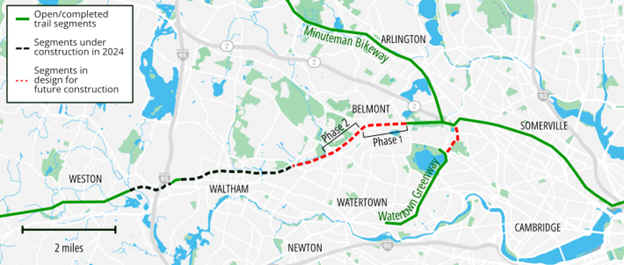
Note; Heading East, a short Gap exists in Waltham to the Belmont town line. Belmont's section of the Mass Central Rail Trail is currently in the design phase, as of 2025. See; Map Below.
Belmont Phase 1 construction; See; Map Below.

From Beaver Street, the paved Mass Central Rail Trail travels West, alongside the active RR tracks. Beaver Brook follows alongside the trail, which you cross over a couple of times. As you travel up to an old RR Trestle you'll pass by an old RR Brakeman's Warning Pole. + See; RR Brakeman's Warning Pole Below. Cross the old RR Trestle over Linden St at 0.7 miles. After crossing the bridge a wooden ramp leads down to the future Linden Street parking lot. Follow a high berm to a bridge over Beaver Brook with Lyman Pond to your right. Cross Middlesex Circle where you'll follow a shaded, residential corridor. Cross Lyman St and look right to spot an old RR Switch. + See; RR Switch Below. Some old RR tracks still alongside the trail. Travel past the Waltham Police station before crossing Lexington St at 1.3 miles where the trail follows a commercial corridor. Cross Bacon St where you'll find a small water garden (filters rain water). The trail starts up a slight incline, crossing Hammond St at 1.8 miles. Here you'll find the old Waltham Highland RR Station. Old RR tracks still here and they utilized old RR tracks as edging as well. Pass by a larger water garden as you enter a more secluded corridor. Cross prospect Hill Rd at 2.1 miles. At 2.6 miles look left to spot an old cement RR Marker reading R (Don't know the meaning) and just before you crest the hill another old cement RR Marker XC on your left. + See; RR Marker XC Below. You travel down through a tunnel underneath Border Rd before coming to Hillside Road at 3 miles and the current end of the trail.
Note; Trail Gap. Heading West, the trail is under design in 2025 and will take you across Main St and over I-95 to Jones Rd. See; Map Below (right side of Map/left side completed).
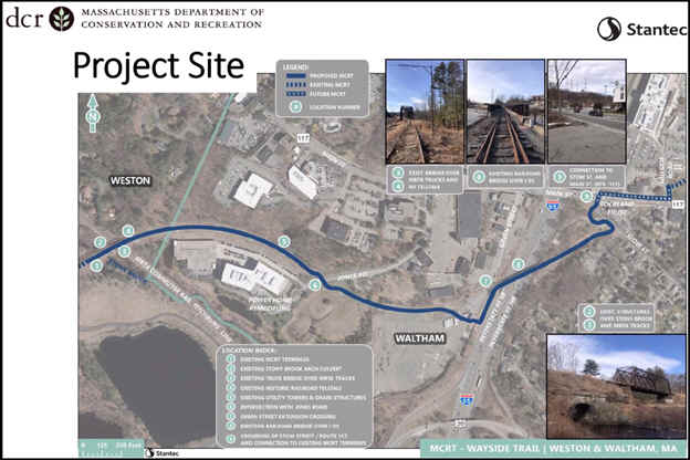
Note; To bypass this Gap, head left out to Main St and travel right, West, on-road (narrow paved trail/sidewalk available). Travel underneath I-95 and take your 2nd left on Jones Rd. Pick up the paved trail on your right, after 0.6 miles.
I have not checked out this new section yet. The paved trail travels West, along an open transmission line. Cross an old RR trestle bridge over some active RR tracks into Weston at 3.9 miles.
Mass Central Rail Trail; Weston to Wayland Section:
Starting from the Waltham/Weston town Line [Eastern End]; [Re-zeroing Mileage] The paved Mass Central Rail Trail travels West, through Weston from the old RR Trestle that crosses over Stony Brook and the active RR tracks. It follows an isolated, open power line corridor. Look right to spot a solar farm and left through a gap in the trees to spot Weston Station Pond. Pass an old RR Mileage Marker on your right at 0.6 miles (should be N91/B13; Northampton 88 miles/Boston 16 miles). These old RR Mileage Markers were located every mile along the railroad. You then cross a high berm over Cherry Brook. You then pass by the old Weston Depot parking lot before traveling underneath Church St at 0.9 miles. The trail diverts briefly off the old rail bed to avoid flooding issues before traveling through a tunnel underneath Conant Rd. You'll pass by another old RR Mileage Marker on your right at 1.6 miles (should be N90/B14) before traveling underneath Concord Rd. Pass by the Jericho Town Forest parking area on your left at 2.2 miles. At 2.8 miles look right to spot an old RR rail holder. Enter Wayland and cross Plain Rd at 3.2 miles, then look left to spot an old granite RR Whistle Post. + See; RR Whistle Post Below. Pass another old RR Mileage Marker on your right at 3.6 miles (N88/B16) followed by an old cement RR Whistle Post on your right. Cross two more roads before passing by an old RR Freight House (old RR tracks) on your left and coming to Route 27 where a cross-light takes you over to the Wayland Depot parking lot at 4.5 miles. The old RR Depot is open. Old RR tracks still in place here. The trail continues West as stone-dust. Here you'll find an old RR Switch + See; RR Switch Below and just after crossing the old RR tracks on your left is the remains of an old RR Turntable. + See; RR Turntable Below. Pass another old RR Mileage Marker on your right at 4.6 miles (N87/B17). To your left is an old RR R Marker? followed by another old RR Track Switch. Pick up a wide cement trail as you pass by a shopping plaza before coming to Route 20 in Wayland after 4.9 miles and the current end of the trail.
Note; Trail Gap. The survey work for construction of the final mile in Wayland, from Route 20 West, through the Wash Brook marsh to the Sudbury Sub-Station in Sudbury has been completed, but construction is not slated until 2027.
Mass Central Rail Trail; Wayland to Hudson Section:
Starting from the Sudbury Sub-Station in Sudbury [ Eastern End]; [Re-zeroing Mileage]
Note; Trail Gap. The survey work for construction of the final mile in Wayland, from the Sudbury Sub-Station in Sudbury East, through the Wash Brook marsh to Route 20, has been completed, but construction is not slated until 2027.
Note; From the Sudbury Sub-Station, as of Oct 2024, the gravel base is down and the trail is actively under construction.
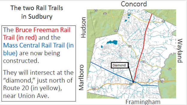
Starting from the Sudbury Sub-Station in Sudbury, the Mass Central Rail Trail travels West. [Re-zeroing Mileage] The trail travels through the woods and underneath Landham Rd, then follows a berm. You'll pass by an old RR Mileage Marker (N85/B19; Northampton 85 miles/Boston 19 miles) on your right at 0.3 miles. These old RR Mileage Markers were located every mile along the railroad. You then travel alongside the Wash Brook marsh. Pass by an old RR Signal + See; RR Signal Below, before a causeway takes you across a bridge over Hop Brook at 0.8 miles. Re-enter the woods as the trail turns Northwest. Pass by a restored RR Whistle Post and 1890 B&M RR Section House on your right, before crossing Route 20 at 1 mile. Trail parallels Station Rd through an industrial corridor, before crossing Union Ave. Pass by the old Sudbury RR Depot, next to an old RR Mileage Marker (N84/B20) on your right, before coming to the "Diamond" after 1.3 miles. This is where the Bruce Freeman Rail Trail & Mass Central Rail Trail; Wayside Branch cross. Map Board, BIKE STATION & Union Street parking area.
Note; Future construction will continue the Bruce Freeman Rail Trail South, another 1.3 miles to Framingham, where the trail will continue South, another 3.5 miles, traveling underneath I-90 to Framingham State University. Currently, as of 2025, the Sudbury section is in the design phase.
Note; The Sudbury section of the Mass Central Rail Trail; Wayside Branch is still under construction and will be paved in 2025. See; Maps Below.
3 Major Trail Projects Are Still Under Construction in 2025

Project 1 is a rehabilitation of the Linden Street railroad bridge in Waltham in 2025.
Project 2 is half complete. The Western Section is done & the Eastern Section is under design in 2025.
Project 3 will pave the
recently-completed utility corridor from Wayland
to Hudson starting Spring 2025..
Continuing Northwest, along the Mass Central Rail Trail; Wayside Branch.
Travel through the woods along the flat, straight rail bed. Cross Horse Pond Rd at 2.1 miles, followed by an old RR Signal + See; RR Signal Below, on your left, followed by RR Mileage Marker (N83/B21) on your right. Cross Peakham Rd, followed by Dutton Rd at 3.2 miles. Cross a bridge over Hop Brook at 3.5 miles. You cross into Hudson and then pass by some old cement RR Rail holders on your right at 4.3 miles. This is where the railroads would store extra track. Pass by an old cement RR Whistle Post. + See; RR Whistle Post Below, before crossing White Pond Rd. You then follow a causeway through a marsh, before passing by RR Mileage Marker (N80/B24) at 5.2 miles and crossing Parmenter Rd. You'll travel alongside the Charter Oak Country Golf Club and through an industrial corridor. Pass another cement RR Whistle Post and another old RR Signal on your left, before crossing Main St at 5.9 miles. You'll now pass several old RR Switches + See; RR Switch Below and track along your left. Pass by an old granite RR Mileage Marker? next to the Iron Works. Next, follow a causeway through a large marsh, crossing a bridge at 6.6 miles. You then travel through a tunnel underneath Chestnut St, before coming to Wilkins St (Route 62) at 7.5 miles.
Note; Across the street is the Wilkins Street (Route 62) parking lot, which is also the Northeastern End of the Assabet River Rail Trail's Southern Section in Hudson.
Note; The old rail bed of the Mass Central Rail Trail continues to the left, West, of this parking lot, along a high berm. The RR Line then crossed over the Assabet River Rail Trail, via a long gone RR bridge. The old rail bed then continues West, parallel to the Assabet River Rail Trail.
So, from the Wilkins Street (Route 62) parking lot, the Mass Central Rail Trail will utilize the Assabet River Rail Trail, West, to Main St, where it crosses the road. It then continues West, crossing a bridge over the Assabet River and continuing alongside Main St. Quickly come to Priest St, across Main St. Here the trail cross Main St and follow Priest St North, to the old Mass Central rail bed after 8.4 miles.
Note; The Mass Central Rail Trail will continue West, parallel to the Assabet River Rail Trail, to Felton St and is under design in 2025.
Old Railroad Equipment Explained:
+ RR Whistle Post:
The Whistle Post,
was a post with a large "W" engraved or painted on it. This
meant the railroad engineers were to start sounding the trains Whistle.
The Whistle posts
were usually placed 0.25 miles
in advance of a road crossing,
bridges, tunnels and other points. Usually, there would be a post placed on both
sides of the crossing, covering both directions.
+ RR Switch:
A RR Switch is a mechanical
installation enabling trains to be guided from one track to another, such as at
a junction or where a spur or siding branches off.
+ RR Signal:
Railroad
Signals direct the engineman on how to proceed. They are categorized into
two levels: Permissive and Absolute. Permissive signals alert train operators
there is an obstruction on the tracks ahead. They are considered
“permissive” because their function is to protect. After the stop, they can
continue forward at a slower speed, commonly referred to as the “restricted
speed.” An absolute signal occurs at any point of the track where there’s an
interruption. They are considered “absolute” because their function is to
control. When a train reaches the absolute signal, it must come to a complete
stop and stay stopped until the signal indicates it’s safe to proceed. There
are different types of Railroad Signals. Semaphores consist of blades,
set to different positions, while Light Signals use different color
lights/number combinations.
+ RR
Brakeman's
Warning Pole:
Prior to 1888 when Westinghouse developed a reliable air
brake, stopping a train or a rolling car was very primitive. Iron wheels,
located atop cars, were connected to a manual braking system by a long metal
rod. The brakemen, usually two to a train, would ride on top of the car. On a Whistle
signal from the engineer, the brakemen, one at the front of the train and one at
the rear of the train, would begin turning the iron wheels to engage the brakes.
The warning pole consists of a rail in the shape of an upside down L,
hanging over the center of the trail. The chains hanging down over the rail line
would hit the railroad brakeman, who was on top of the train and warn him of an
upcoming bridge or tunnel.
+ RR Turntable:
RR Turntables are bridges that spin
and are used for turning locomotives and rolling stock. The earliest use for a Turntable
was to redirect trains. The very first locomotives could only run in one
direction, so a device was needed to turn them. Even with bi-directional trains
(can operate in either direction) today, turntables are still used as a
convenient means for moving locomotives and other equipment onto tracks headed
in the correct direction.
+ RR Marker
XC:
A RR Marker labeled XC indicates
the start of a Crossing
Circuit. These markers are placed on posts at the ends of the Circuits,
which are designed to detect when a train is approaching and activate the
crossing's warning system. The letters stand for X-Crossing
& C-Circuit.
HH
CLICK HERE FOR MASS CENTRAL RAIL TRAIL MAP
CLICK HERE FOR OLD MASS CENTRAL RR MAP
BEFORE YOU SET OUT BE SURE TO READ THE
WAIVER OF RESPONSIBILITY AND DISCLAIMER
BIKE IT OR HIKE IT