
MYSTIC RIVER PATHS:
MALDEN RIVER GREENWAY:
SPOT POND GREENWAY:
MEDFORD/SOMERVILLE, MASSACHUSETTS
-BIKE IT OR HIKE IT-
Last Updated:
August 18, 2025Length:
Upper Mystic River
Path; 5.7 miles
Lower Mystic River Paths; North Side; 1.5 miles.
Lower Mystic River Paths; South Side; 3.7 miles
Wellington Greenway/Malden River Greenway; West Side; 1.6 miles
Malden River Greenway-East Side/Lower Mystic River Paths; North Side; 4 miles (with on-road sections)
Spot Pond Brook Greenway; 1.1 miles
Difficulty: Upper Mystic River Paths; Easy. Flat, paved or stone-dust surface plus some hard packed dirt surfaces.
Lower Mystic River Paths; Easy. Flat, paved or stone-dust surface.
Malden River Greenway; Easy. Relatively flat paved trail.
Spot Pond Brook Greenway; Easy. Flat, paved trail.
Directions:
Upper Mystic River Paths: From the junction of Routes 2 & 3/16 (Alewife Brook Pkwy) travel east on Routes 3/16 (Alewife Brook Pkwy):
To Start from the Wedgemere Station parking lot in Winchester [Northern End]; (Fee; $1 per hr 7 am and 6 pm M-F, maximum charge $5 per day. Otherwise Free) Head left on Route 3 for 4 miles to Church St and turn right. Quickly come to Bacon St and turn right. Just before the RR bridge turn right on Mystic Valley Pkwy. Parking lot is on your left.
To Start from the Decatur Street parking lot in Arlington [Southern End]; Continue north on Route 16 (Alewife Brook Pkwy) to the Mystic Valley Pkwy and turn left. Cross over Alewife Brook and turn left on Decatur St. Parking lot on your left. This is also the Northern terminus of the Alewife Brook Greenway .
To Start from Veterans Memorial Park parking lot in Medford [Eastern End]; Continue north on Route 16 (Alewife Brook Pkwy) to the Mystic Valley Pkwy and turn right. You'll cross over the Mystic River. Just before you cross over the Mystic River again, the parking lot will be on your right.
Lower Mystic River Paths; North Side:
To Start from the Mystic Riverbend Park, Freedom Way parking lot in Medford [Northwestern End]; From I-93 southbound take exit 22 to the Mystic Valley Pkwy (Route 16) and travel left across the Mystic River. Immediately turn left on Locust St then left again on Freedom Way towards Hormel Stadium. Come to a stop sign. The Lower Mystic River Path and *Trail Circle is on your left along with a small parking area. Big parking lot straight ahead. Start from the *Trail Circle.
To start from Torbert Macdonald Park in Medford [Northern Section]; From the junction of Routes 16 & 28, take Route 16 (Mystic Valley Parkway) west and immediately turn left into McDonald Park. The State Police building is straight. Turn right for the parking lot.
To start from Gateway Center trail parking lot in Everett [Central Section]; From the traffic circle and junction of Routes 16 & 99 follow Route 16 (Revere Beach Pkwy) west to a 2nd traffic circle. Take the Mystic View Rd exit alongside the Gateway Center. Take your second left into the Gateway Center parking lot and spot the reserved parking spots on your right for the trail. Green Map Board located here.
To start from Encore Boston Harbor Casino in Everett [Central Section/Southern End]; From the traffic circle and junction of Routes 16 & 99 follow Route 99 (Broadway) south to the Casino. You can turn right into the Casino parking garage or left on Mystic St to exterior parking lots.
The Upper Mystic River Reservation [West of I-93] connects 4 Parks (Clippership Park, Veterans Memorial Park, Dugger Park & Mystic Lakes State Park) via Paths alongside the Mystic River (Medford; North Side of river & Arlington; South Side of river). At it's Northern End you can access the Tri-Community Greenway in Winchester. At its Center you can access the Alewife Brook Greenway in Arlington.
The Lower Mystic River Reservation [East of I-93] connects 8 Parks (Drane Park, Mystic Riverbend Park, Torbert Macdonald Park, Station Landing Park, Sylvester Baxter Riverfront Park, Draw Seven State Park, Ryan Playground & Mary O'Malley Park via Paths alongside the Mystic River (Medford, Everett & Chelsea; North Side of river & Medford, Somerville & Charlestown; South Side of river). At its Center you can access the Malden River Greenway in Medford & Northern Strand Community Trail in Everett. At it's Southern End you can access the Boston Harborwalk; Charlestown in Cambridge.
The parks are run by the Metropolitan District Commission and admission to the reservation and its parks is free. For more information visit; MYSTIC RIVER RESERVATION & MYSTIC RIVER GREENWAYS .
The Malden River Greenway follows both shorelines of the Malden River North, to Malden. The Malden River flows into the Mystic River between Wellington & Everett. In Malden Spot Pond Brook fed the Malden River. A portion of the brook is now underground. Plans are underway to connect two short sections of the existing Spot Pond Brook Greenway South, to the Malden River Greenway. For more information visit; MALDEN RIVER GREENWAY .
In Cambridge at Alewife T- Station, a stop on the commuter rail line into Boston is a "Hub" for 5 Trails (plus interconnecting Trails).
Heading West the Mass Central Rail Trail; Boston-Cambridge-Belmont also known as the Fitchburg Cutoff, will eventually extend to Northampton.
Heading East the Mass Central Rail Trail; Boston-Cambridge-Belmont also known as the Red Line Linear Path, which becomes the Somerville Community Path, will bring you to North Point Park in Cambridge, where you may connect to the Boston Harborwalk; Charlestown and Charles River Bikeway .
Heading Northwest the Minuteman Bikeway brings you to Bedford, where you may connect to the Bedford Narrow Gauge Spur and Reformatory Branch Rail Trail.
Heading Northeast the Alewife Brook Greenway brings you to the Mystic River, where you may connect to the Mystic River Paths .
Heading South the Fresh Pond Bike Path brings you to Fresh Pond, where you can access the Fresh Pond Loop Trail and continue Southeast, along the Watertown Branch Rail Trail to Watertown.
UPPER MYSTIC RIVER PATHS:
The Upper Mystic River Reservation Paths refer to the Paths along the Mystic River West, of I-93. The Northern Section of these Paths travel between the Mystic Valley Pkwy and alongside Mystic Lakes. The Southern Section of these Paths travel along both the North & South Sides of the Mystic River, until you near I-93, which takes up much of the South Side, limiting future creation of a trail. You can also access the Alewife Brook Greenway from the Southern Section.
Upper Mystic River Path; Mystic Lakes:
Northern Section:
Starting from the Wedgemere Station parking lot in Winchester [Northern End]; You can also access the Tri-Community Greenway here. Exit the parking lot out to the Mystic Valley Pkwy.
Note; In 2023 a design is underway to complete the Upper Mystic River Path; Mystic Lakes South, for 2 miles.
Travel South, on-road (wide shoulder available) along the Mystic Valley Pkwy. After crossing the Aberjona River you'll pick up the paved Upper Mystic River Path; Mystic Lakes and come to an intersection at 0.3 miles.
Note; Straight leads to the Shannon Beach parking lot.
I haven't checked out this section. Turn right where the paved path Loops around Shannon Beach Park next to Upper Mystic Lake then back out past Shannon Beach & Shannon Playground to the Mystic Valley Pkwy. Here the trail continues between the Pkwy and Upper Mystic Lake (I believe as stone-dust). Pass by 2 parking lots before crossing into West Medford. Pass by 2 more parking lots before coming to a road at 1.3 miles.
Note; Right leads to the Mystic Lakes Dam and parking lot.
The trail continues between the Pkwy and Lower Mystic Lake (I believe as stone-dust). You lose the lake and the trail turns to hard packed dirt. Come to the High Street Bridge after 2.1 miles.
Note; Southeast of here, the Upper Mystic River Paths follow along both the North Side (Medford) & South Side (Arlington) of the Mystic River. However, there are Gaps along both sides of the river, which require utilizing the opposite side at times. Either route results in roughly the same Mileage.
Upper Mystic River Path; North Side:
Southern Section:
Starting from the High Street Bridge in Medford; [Continuing Mileage; 2.1 miles] Head South, along the hard packed narrow dirt Upper Mystic River Path; North Side alongside the Mystic River. After passing through Dugger Park (Playground & sports courts) you'll cross over Harvard Ave where the trail continues south. Come to the Boston Ave Bridge.
Note; Past here, the Upper Mystic River Path; North Side is blocked by homes and RR tracks.
Head right, over the Mystic River to connect to the Upper Mystic River Path; South Side at 3.2 miles. *Connection A.
Upper Mystic River Path;
South Side:Southern Section:
Starting from the High Street Bridge in Arlington; [Continuing Mileage; 2.1 miles] Head South, along the hard packed narrow dirt Upper Mystic River Path; South Side alongside the Mystic River. At some point the trail turns to stone-dust. Cross River St as the trail turns East. You come alongside the Mystic Valley Pkwy where you'll find a crosswalk at 2.9 miles.
Note; Crossing over the Mystic Valley Pkwy brings you to the Decatur Street parking lot & Alewife Brook Greenway .
Continuing East, the trail is now paved. Cross over Alewife Brook where the trail parallels the Pkwy. Cross Boston Ave at 3.2 miles *Connection A.
Travel underneath the RR bridge and come to Auburn St.Note; Past here, the Upper Mystic River Path; South Side is not complete.
Upper Mystic River Path; North Side:
Head left, over the Mystic River, to a crosswalk over Auburn St in Medford. Another crosswalk takes you over the Mystic Valley Pkwy where you'll pick up the wide paved Upper Mystic River Path; North Side at at 3.4 miles *Connection B. Here the trail travels through the open field to Veterans Memorial Park where it splits.
Note; Straight brings you to the intersection of Winthrop St & Mystic Valley Pkwy.
Continue right, past sports fields and across Winthrop St. *Connection C.
Note; Right, the Winthrop Street Bridge takes you over the Mystic River to South St at 3.9 miles. Here you'll find the South Street BIKE LANE, however, it is one-way (West only). See; Upper Mystic River Path; South Side Below.
Pass by a community garden where the trail travels back alongside the Mystic River. The path turns to stone-dust as it passes by the Condon Band Shell and a canoe put-in, before passing by the Veterans Memorial Park parking lot and returning to the Mystic Valley Pkwy at 4.1 miles.
Note; Past here, the Upper Mystic River Path; North Side is blocked by homes.
Upper Mystic River Path; South Side:
Head right, following the paved path alongside the Mystic Valley Pkwy, across the Mystic River to a cross-light. *Connection D.
Note; The paved path to your right travels South, out to South St. Here, the South Street BIKE LANE travels West, one-way (West only) to the Winthrop Street Bridge.
Note; Past here, the Upper Mystic River Path; South Side is not complete.
Head right, across the Mystic River to Veterans Memorial Park. *Connection C.
Head left across the Mystic Valley Pkwy and you'll rejoin the paved Upper Mystic River Path; South Side. Come to the John D Hand Memorial pedestrian bridge on your left.
Note; This pedestrian bridge travels over the river and brings you to High St in downtown Medford.
Continue straight along the trail and you'll come to Main St at 4.3 miles.
Note; East, the trail quickly ends next to the Mystic Valley Pkwy. Past here, the Upper Mystic River Path; South Side will be difficult to build, as it is located in the narrow, Mystic Valley Pkwy & I-93 corridor.
Turn left, across the Main Street Bridge. West Side of bridge has a separated path, while the East Side has a BIKE LANE.
Upper Mystic River Path; North Side:
This brings you to Clippership Drive on your right, where you'll find a sidewalk and BIKE LANE. A narrow greenway along your right constitutes Clippership Park, where you'll find an informational sign and benches overlooking the river. Come to Riverside Ave at 4.6 miles. I haven't checked out this new section yet. Here the wide, paved Clippership Connector takes you above the river past the Riverside Towers and underneath I-93. Travel around a little inlet, then past the Riverside Yacht Club to Riverbend Park, where you'll pick up the Riverbend Park Trail after 5.2 miles.
Note; The paved Riverbend Park Trail travels around the park. Head left, East, past the Medford Labyrinth, then right, to an intersection, then right, South, behind the school. During school hours this section should not be utilized. Bare right at the fork through Drane Park (sports fields) and travel past the Drane Park parking lot bearing left past the Community Garden. This will bring you past the McGlynn Elementary School (playground) to the 2nd Trail Circle after 0.4 miles.
Head right, South, along the paved trail and travel alongside the Mystic River. Informational signs are located all along the trail. Pass by the Medford Dog Park, 2nd Trail Circle, Hormel Stadium and boat launch, before coming to the *Trail Circle (where a small granite circle is embedded in the path) and Freedom Way parking lot after 5.7 miles. BLUEbikes STATION located nearby. A Map Board is located here next to some granite benches. This is the start of the Lower Mystic River Paths. See Below.
LOWER MYSTIC RIVER PATHS:
The Lower Mystic River Paths are divided into 2 Sections:
Lower Mystic River Path; North Side (Path travels along the North Side of the river). Connection to Wellington Greenway & Malden River Greenway.
Lower Mystic River Path; South Side (Path travels along the South Side of the river). Connection to Boston Harborwalk; Charlestown .
Lower Mystic River Path; North Side:
Northern Section:
Continuing from the *Trail Circle; [Re-zeroing Mileage]
Note; To access the Lower Mystic River Path; South Side bear left, alongside Freedom Way to Locust St. See; Lower Mystic River Path; South Side Below.
Bear right and continue straight where the trail travels underneath the Mystic Valley Pkwy (Route 16) Bridge. A wide paved trail travels East, a
longside Mystic Valley Pkwy (Route 16) bringing you to Macdonald Park after 0.3 miles. Here you have multiple trail options through the park. I chose to always keep right at all intersections, this ensures you'll always travel along the Mystic River.Note; A paved trail continues East, alongside Mystic Valley Pkwy (Route 16) and will take you to the Torbert Macdonald Park parking lot.
Bear right passing by a wooden observation tower. This tower overlooks a marsh between you and the river and affords you views of downtown Boston. Continue right, South, at the next intersections (turning left simply brings you through the center of the park). You now travel East, alongside the Mystic River, passing by a pier and boat launch. Lots of benches and picnic tables here. The trail then turns inland, North, along an inlet bringing you back out to Mystic Valley Pkwy. Head right, East, where you'll pass by a platform overlooking this inlet and keep right to another intersection at 1.7 miles.
Note; Straight ahead is the Torbert Macdonald Park parking lot and Map Board.
Continue right, South, where the trail enters the woods. Continue straight at the next intersection. You'll cross a bridge and come to Fellsway (Route 28) after 1.9 miles.
Note; Right, South, leads to the Wellington (Route 28) Bridge where a SEPARATED BIKE LANE takes you 0.2 miles across the Mystic River to Somerville where you can connect to the Lower Mystic River Path; South Side.
Note; Future plans call for building a boardwalk that will take you underneath the Wellington (Route 28) Bridge to the East Side of Fellsway, where the Lower Mystic River Path; North Side continues. See; Map Below.
Current Detour; Head left, North, along the sidewalk to a cross-light over busy Fellsway (Route 28) then right, South, to the start of the Wellington Greenway after 2.1 miles.
Lower Mystic River Path; North Side & Wellington Greenway:
The Lower Mystic River Path; North Side utilizes the paved Wellington Greenway alongside the Mystic River. [Continuing Mileage] Travel Southeast, through Station Landing Park, before coming to a boat launch and the Mystic Wellington Yacht Club. The trail continues South, before traveling underneath a RR Trestle to the mouth of the Malden River and an Overlook at 2.6 miles. The Overlook sits at the end of the peninsula and includes a circular granite seating area with views of the Mystic & Malden Rivers and the Amelia Earhart Dam. This is the start of the Southern End of the Malden River Greenway; West Side.
Malden River Greenway; West Side:
[Continuing Mileage] Continuing from the end of the Wellington Greenway, the paved Malden River Greenway; West Side travels North, between the Malden River and RR tracks to the Wellington Station parking lot where the trail currently ends after 2.7 miles.
Note; Future construction will continue the trail North, between the parking lot & Malden River to the Revere Beach Pkwy (Route 16) Bridge and connecting into the existing path.
Current Detour; Continue North, along the outer edge of the parking lot and you'll come to a paved trail. Follow this to a sidewalk out to Revere Beach Pkwy where you'll pick up the paved Malden River Greenway; West Side on your right.
Note; Straight takes you East, across the Revere Beach Pkwy (Route 16) Bridge where you'll connect to the Malden River Greenway; East Side. See Below.
Follow
the trail down and underneath the Revere
Beach Pkwy (Route 16) Bridge where the Malden
River Greenway; West Side utilizes the Rivers
Edge Trail at 3 miles. The wide paved trail continues North,
alongside the Malden
River. Enter the Park at Rivers Edge where the trail includes pedestrian only
stone-dust paths alongside the river, informational signs and William
Shoemaker Boathouse. The trail then Loops around an open area out to Commercial
St at 3.8 miles.
Note; Future plans will continue the trail North, alongside the river to Medford Street. Another short section of trail exists South, of Medford Street but dead ends.
Note; From Medford Street you can cross the Malden River to access the Malden River Greenway; East Side & Northern Strand Community Trail. Further North, is the Spot Pond Brook Greenway. See Below.
Lower Mystic River Path; North Side:
Central Section:
Starting from the Encore Boston Harbor Casino entrance at Horizon Way & Broadway below the Encore sign in Everett; [Re-zeroing Mileage] Parking is located in the Casino parking garage or across Broadway. Covered bike parking is located next to the parking garage exit. North of here, you'll find a BLUEbikes STATION.
Note; A Gap exists to the Southern Section of the Lower Mystic River Path; North Side located in Mary O'Malley State Park, East, of here, along the Mystic & Island End Rivers. See; Mary O'Malley State Park Below.
The brick pavers Lower Mystic River Path; North Side travel Southeast, around the Casino. Travel around a Garden circle and keep straight at an intersection. Lots of greenery. Keep straight at the next intersection. Come to the Mystic River side of the casino [Walk Bike when crowded]. Pass by an entrance to the Casino, where you'll find a Water Taxi dock. They did a great job with plantings (artificial grass). Follow the inlet out to the Mystic River, past a gazebo and come to a BLUEbikes STATION . Straight ahead is a RR bridge. Left a piece of land juts out to the river.
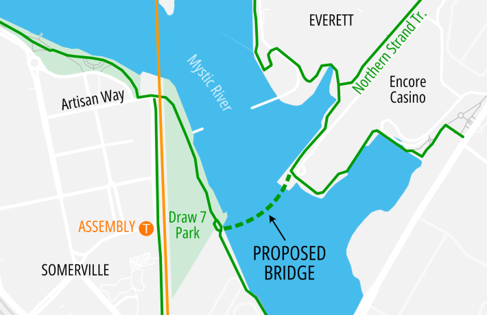
Note; A pedestrian bridge is scheduled to be built in 2026 that will cross the Mystic River and connect to Draw 7 Park in Somerville and the Lower Mystic River Path; South Side. See; Map Below.
The paved trail continues North, past the casino, where it travels underneath the RR bridge to the rear of Gateway Center at 0.6 miles.
Note; On your right is the Southern End and start of the Northern Strand Community Trail .
The trail continues out to and across Mystic View Rd bringing you to an overlook of the ***Craddock Locks at the Amelia Earhart Dam (See; Bottom of page) as you enter Gateway Park. Here the Malden River meets the Mystic River. This is the start of the paved Malden River Greenway; East Side which travels North, alongside the Malden River.
Malden River Greenway; East Side:
[Continuing Mileage] Come to an intersection after 1 mile.
Note; Right leads up to and across Mystic River Rd, where you'll find the Gateway Center Trail parking lot and Map Board.
Note; Future construction will build a trail & boardwalk that takes the trail down through Gateway Park to the Malden River, then North, across an inlet, where it will connect to the completed trail next to the Revere Beach Pkwy (Route 16) Bridge. I believe construction will begin in 2025. See; Map Below.

Continue left through Gateway Park where the trail splits (either path is fine) as you travel through open woods and back out to Mystic View Rd. Turn left, West and follow the sidewalk out along Route 16. Before the Revere Beach Pkwy (Route 16) Bridge you'll pick up a paved trail on your left at 1.5 miles. Follow this trail down and underneath the Revere Beach Pkwy (Route 16) Bridge to an intersection.
Note; Straight brings you back up to Route 16. If you head right, West, across the Revere Beach Pkwy (Route 16) Bridge you'll connect to the Malden River Greenway; West Side.
Heading left, the Malden River Greenway; East Side utilizes the Village Landing Park Trail, which travels North, alongside the Malden River. The trail currently ends at a parking lot after 1.8 miles.
Note; As of August 2023, construction was underway to bridge the current Gap to the next section in Rivergreen Park, which travels around Rivergreen Park and is called the Everett Riverwalk. See; Map Below.

Current Detour; To access the next section you'll need to travel right through the parking lot out to Santilli Hwy. Turn left following the BIKE LANE, then left again on Air Force Rd (low traffic). This will bring you to Rivergreen Drive and the Rivergreen Park parking lot after 2.3 miles.
Note; Right, across the road, you can access the Northern Strand Community Trail along with a BLUEbikes STATION just North, up this trail.
Again, the Malden River Greenway; East Side utilizes the wide, paved Everett Riverwalk. The trail travels West, alongside Rivergreen Drive before bearing left around an industrial building and above South Creek. Come to an intersection and bridge on your left.
Note; As of August 2023, construction was underway to bridge the current Gap to the Southern Section at Village Landing Park Trail. A new bridge over the creek has already been constructed here.
Come to the Malden River at 2.6 miles. Now, the trail heads North, along the river passing by an overlook on your left and coming to Rivergreen Dr.
Note; On your left is a canoe/kayak launch.
Pass by a pavilion on your right and a parking lot. You travel around the park (sports fields, sports courts, playground and trails throughout) curving right East, past a Dog Park out to the Northern Strand Community Trail after 3.3 miles.
Note; On your right you can access Everett Parkland which has a 0.3 mile paved figure 8 Loop Trail around a grassy knoll.
Note; Another Gap currently exists, as of 2025, North, to the next section at Medford St. This is National Grid property and I'm not sure they will try to build a trail around it. See; Map Above.
Here, the Malden River Greenway; East Side, utilizes the paved Northern Strand Community Trail which travel North, to Medford Street in Malden. Cross Medford St and head left. Just before the bridge over the river you'll pick up the Malden River Greenway; East Side on your right at 3.8 miles. The open, stone-dust trail continues North, alongside the river bringing you out to Canal St after 4 miles.
Note; Future plans call for continuing the trail North, to Charles St, where the river is underground. Plans possibly include uncovering the Malden River and extending the trail to Centre St.
Note; Future plans also call for a connection the Spot Pond Brook Greenway, which is partially built, North, of here. See Below.
Lower Mystic River Path; North Side:
Southern Section:
Starting from the Encore Boston Harbor Casino entrance at Horizon Way & Broadway below the Encore sign in Everett; Detour; To connect to the Lower Mystic River Path; North Side-Mary O'Malley SP & Island End River Trail from here you'll need to travel on-road. Head left, North, on Broadway utilizing a BIKE LANE. Turn right on Beacham St at 0.3 miles and head East, along another BIKE LANE which ends at 0.9 miles. Continue on-road around a sharp bend. Pass Market St and a boat yard before turning right on Justin Dr (may not be a street sign) after 1.2 miles. This road follows alongside the boat yard to a boardwalk, however, you are unable to access the boardwalk here. Follow the boardwalk to the Marina at Admirals Hill in Chelsea after 1.3 miles. Here you can access the Island End River Trail.
Island End River Trail
& Mary O'Malley State Park:Note; Right, North, the Island End River Trail follows a boardwalk along Island End River out to Island End Park after 0.1 miles where you'll find a small gazebo, picnic tables and informational signs. Dead End.
[Re-zeroing Mileage] Heading left, South, along the narrow, pavers Island End River Trail you travel past the Marina at Admirals Hill and Seaport Academy before coming to Mary O'Malley State Park at 0.3 miles. Here, you'll pick up the wide paved Lower Mystic River Path; North Side, as it travels through the wide open park alongside the Island End River, then East, alongside the Mystic River. Tennis courts, playground, picnic tables and pavilions. You pass by a long pier before the trail ends at Commandants Way after 0.9 miles. Straight ahead is the Tobin Memorial Bridge.
Note; A sidewalk follows Commandants Way left, West, past Mary O'Malley State Park where you'll find parking.
Note; If you continue East, on-road along Commandants Way, you'll come below the Route 1 bridge. Turn left, North, along a short drive, which leads to a paved trail. This brings you to the Mystic Dog Park & Outdoor Gym, located underneath the Route 1 bridge after 0.2 miles.
Lower Mystic River Path; South Side:
Starting from Mystic Riverbend Park & Freedom Way parking lot in Medford; BLUEbikes STATION. From the *Trail Circle (where a small granite circle is embedded in the path), Map Board, and some granite benches the trail splits here.
Note; To access the Lower Mystic River Path; North Side bear right and continue straight where the trail travels East, underneath the Mystic Valley Pkwy (Route 16) Bridge. See; Lower Mystic River Path; North Side Above.
Heading South; Bear left alongside Freedom Way out to Mystic River Pkwy, then right across the Mystic Valley Pkwy (Route 16) Bridge and over the Mystic River. Turn right and travel underneath the Mystic Valley Pkwy (Route 16) Bridge along the wide, paved Lower Mystic River Path; South Side. Here the trail travels Southeast, between the river and I-93 crossing into Somerville until you come to the Blessing of the Bay Boathouse at 1.1 miles. There are benches and picnic tables located here. Continue straight past the boathouse and bear right out to Shore Drive where you'll head left along a SEPARATED BIKE LANE. Just before Route 28 you'll turn left along the paved trail to an intersection. Head left to access a boardwalk bypass that takes you underneath the busy Wellington (Route 28) Bridge to the Eastern Side, where you'll find an overlook of the river before coming to an intersection at 1.5 miles next to Grand Union Blvd. Map Board.
Note; To access the Lower Mystic River Path; North Side & Wellington & Malden River Greenways head right up to the Wellington (Route 28) Bridge where a BIKE LANE takes you North, 0.2 miles over the Mystic River to Wellington.
Continue left along the wide paved trail as it travels Southeast, alongside the river through Sylvester Baxter Riverfront Park. A couple of overlooks and dock before coming to an outdoor amphitheatre in Assembly Square/Row at 1.8 miles.
Note; Assembly Square is a neighborhood in Somerville which is named for a former Ford Assembly Plant that was located here. The B&M RR operated here and had lots of RR Spurs that crisscrossed the area. The MBTA's Assembly Station is located here. At the top of the amphitheatre are some relics from the RR days in the form of 4 old iron RR towers. Assembly Row refers to the mixed use development located here which includes lots of shops, restaurants, movie theatre, hotel... Great place to explore and grab a bite to eat. Head up to Great River Rd above the outdoor amphitheatre. If you travel straight, South, along Assembly Row you'll find 3 blocks full of restaurants, shops & entertainment venues. Past Foley St you'll find sports venues and a more park like setting. Another old iron RR tower here. It appears that perhaps an old RR spur used to travel from the outdoor amphitheatre, along Assembly Row and straight through the open air tunnel underneath the Mass General building, located across Revolution Dr. You can travel through the tunnel to a courtyard where a paved path continues straight. On your right a stone-dust path circles the "Great Lawn". The paved trail continues straight out to Grand Union Blvd. This is a distance of about 0.5 miles.
Continuing along the trail you'll pass by a playground before coming to Artisan Way. Head left along a sidewalk past the Winter Hill Yacht Club.
Note; Across Artisan Way spot a paved trail that travels South, between Great River Rd and the RR tracks. It passes by the MBTA's Assembly Station, then alongside Grand Union Blvd before ending at Mystic Ave after 0.6 miles.
Travel underneath the subways Orange” T-Line where the trail is paved. This takes you South, past the Craddock Locks at the ***Amelia Earhart Dam (See; Bottom of page) and Draw 7 Park. Nice views of the Encore Boston Casino across the river. You'll find a picnic pavilion, benches and fishing pier here. You can also see the Bunker Hill Monument from here. Travel underneath a railroad bridge at 2.2 miles.
Note; A pedestrian bridge is scheduled to be built in 2026 that will cross the Mystic River and connect to the Encore Boston Harbor Casino in Everett and the Lower Mystic River Path; North Side and Northern Strand Community Trail. See; * Map Above.
The Charlestown Seawall Trail continues South, alongside the river through the MBTA’s Charlestown Yards, before bringing you to the Route 99 Bridge at 2.6 miles. Across Route 99 is Ryan Playground in Charlestown where the Lower Mystic River Path; South Side continues, however, their is no direct access across this busy road. To access Ryan Playground head right, South, along a SEPARATED BIKE LANE on Alford St S. You'll come to a bridge over Route 99 which contains a BIKE LANE, however, this is a One-Way (wrong way) Lane. Instead continue along the Alford St S BIKE LANE to Maffa Way where a BIKE LANE left takes you over Route 99 to Alford St N and head left, North, along a SEPARATED BIKE LANE. This will bring you past the Ryan Playground parking lot on your right. Continue to the next entrance and turn right then immediately left along the gravel road. This returns you to the Mystic River after 3.2 miles [0.6 mile detour].
Note; To Loop back to the Lower Mystic River Path; North Side and Encore Boston Harbor Casino, a SEPARATED BIKE LANE takes you North, across the Route 99 Bridge over the Mystic River to Everett. Left spot the big wind turbine. The SEPARATED BIKE LANE continues North, becoming just a BIKE LANE past Dexter St. Come to Mystic St and cross Route 99 left the Encore Boston Harbor Casino entrance at Horizon Way below the Encore sign and start of the Lower Mystic River Path; North Side after 0.7 miles.
The Lower Mystic River Path; South Side continues East, along a wide boardwalk next to the river. This is also part of the Boston Harborwalk; Charlestown Section. The trail brings you to a parking lot (Caution stairs) where a stone-dust trail takes you to wooden pier with a trellis and picnic tables. Follow the pier out to a fishing dock, where you can spot a large wind turbine across the river. Continuing East, you pass by Schrafft's boat ramp where you turn left back to the river. A wide, paved trail continues alongside the river, ending after 3.7 miles.
Note; The Boston Harborwalk; Charlestown continues right, South, along the narrow stone-dust Schrafft's Walking Trail.
Spot Pond Brook Greenway:
The first of 2 completed sections of this trail start from Mountain Ave in Malden.
Note; Future plans call for continuing the Spot Pond Brook Greenway South, from Coytemore Lea Park, connecting to the Northern Strand Community Trail at Charles St. See; Map Below. Note; In the Map below, North, is on the right side of the Map.

Starting from Mountain Ave in Malden [Southern End]; The Spot Pond Brook Greenway travels North, 0.1 miles through Coytemore Lea Park (Pool, sports courts, playground) to Clifton St.
Note; A Gap exists, as of 2025, to the next completed section North, at Winter St.
Detour; Turn left, on-road, along Clifton St (residential), then right up Linden Ave (residential) and right again on Clinton St (residential). Take your first left through an industrial corridor out to Winter St after 0.5 miles. The paved trail picks up across the St next to Banks Pl.
[Continuing Mileage] The paved Spot Pond Brook Greenway continues North, alongside Banks Pl. Spot Pond Brook is along your right. Pass by Oak Grove East T-Station on your left before coming to a pedestrian bridge across Spot Pond Brook at 0.7 miles.
Note; This bridge leads to Fairlawn St.
Continue North, alongside Banks Pl where you'll encounter a 2nd bridge. Take this across the brook to a narrow paved trail at 0.9 miles.
Note; Right takes you South, alongside Spot Pond Brook to Windsor at Oak Grove Dog Park where the trail ends after only 0.1 miles.
Continue North, alongside Spot Pond Brook passing by a green space over the brook with a picnic table. Emerge on Banks Pl after 1.1 miles and the end of the trail.
Note; Right, along Banks Pl, will quickly bring you to Main St. Across the street is the Pine Banks Park parking lot.
***Extensive salt marsh lined the banks of the Mystic River until 1909, when the first dam was built across the river (Craddock Locks), converting salt marsh to freshwater marsh and enabling development. Today's dam, named for Amelia Earhart, was built in 1966. It converted the Malden River to freshwater non-tidal. This dam was more sophisticated than the simple iron gates of the Craddock Locks. It is a permanent concrete structure with three passages to allow boats to pass through. There is a tower where workers observe incoming boats and open the lock accordingly. The dam is equipped with a pump, and is able to pump freshwater downstream even during high tide to prevent flooding. The river flows backwards at times depending on the dam. It was modeled after the Charles River Dam, which is very similar in structure and purpose. Fish passage has been a problem, as there is no working fish ladder there, but workers do leave the locks open at times to allow fish to pass. Currently, there is no pedestrian access to the dam, although many people are pushing to allow access.
HH
CLICK HERE FOR MYSTIC RIVER PATHS MAP
CLICK HERE FOR MYSTIC RIVER PATHS MAP
BEFORE YOU SET OUT BE SURE TO READ THE
WAIVER OF RESPONSIBILITY AND DISCLAIMER
BIKE IT OR HIKE IT