MANHAN/NEW HAVEN &
NORTHAMPTON CANAL RAIL TRAIL:
NORTHAMPTON-SOUTHAMPTON,
MASSACHUSETTS
MANHAN RAIL TRAIL:
EASTHAMPTON,
MASSACHUSETTS
-BIKE IT OR HIKE IT-
Letterbox Planted: August 16, 2003
Last
Updated:
June 29, 2025
Length:
Manhan/New Haven &
Northampton Canal Rail Trail; 7.3 miles to the Southampton town line (current end)
Hospital Hill Rail Trail Spur Loop;
1.3 mile Loop
Manhan Rail Trail; 2.3 miles
Rocky Hill Greenway; 0.5 miles when complete.
Difficulty:
Manhan/New Haven &
Northampton Canal Rail Trail; Easy. Flat, paved rail trail.
Hospital Hill Rail Trail Spur Loop; Moderate. Steep hill.
Manhan Rail Trail; Easy. Flat, paved rail trail.
Rocky Hill Greenway; Easy. Paved trail.
Directions:
For the Manhan/New Haven &
Northampton Canal Rail Trail [Northern
End]: From I-91:
Northbound:
Take exit 25 and continue to the Route 9 traffic circle. Take the Damon Rd exit.
Continuing along Damon Rd, you travel under I-91 and come to Routes 5
& 10 (King St) at the light. Turn left on King St and follow until you come
to the Kingsgate Plaza on your right. As you turn right
into the plaza look left to spot a spur trail. This
trail runs through the parking lot and connects to the Mass Central Rail
Trail;
Williamsburg Branch
near where it
crosses King St. You need to head left across King St to reach the "Spoke".
Southbound: Take
exit 26 to Routes 5 & 10 ( King St) and continue straight on King St until you come to the Kingsgate Plaza on your
right. As you turn right into the plaza look left to spot a spur trail. This
trail runs through the parking lot and connects to the Mass Central Rail Trail;
Williamsburg Branch
near where it
crosses King St. You need to head left across King St to reach the "Spoke".
To start from the Route 5 parking lot for the Manhan
Rail Trail [Eastern
End]:
Take exit 23 off of I-91 to Route 5 south. You cross a bridge after a
mile and pass by a boat launch. The trail begins next to the sub-station. There
is parking here for several cars. If the area is full, you can also park at the
boat launch.
You can rent bikes in Northampton. See; VALLEY
BIKE SHARE for locations.
Until
the 1930s, there were two parallel railroads that ran north through Northampton.
The Boston & Maine's (B&M) Connecticut River Division, which runs
to this day on the East Side of Route 5, and the
New Haven & Northampton
RR, which basically ran on
the West Side of Route 5.
The RR bed was originally
constructed in 1868 as part of the New Haven & Northampton Railroad
which later was acquired by the New York, New Haven, and Hartford
Railroad—most commonly known as the New Haven Railroad (NH).
The
New Haven & Northampton RR then branched off to Williamsburg.
Remains of the footings for the
overpass over Route 5 are still visible where the line once headed toward what
is now Super Stop & Shop. This commercial development, and the others
just North of here, sit atop what was once the New Haven's classification
yard and engine service facilities, complete with RR Turntable and coaling tower.
This is where the Williamsburg Branch began and what is now referred to
as the Mass Central Rail Trail;
Williamsburg Branch, even though it was never part of the Mass Central RR.
The Mass Central Rail
Trail is a planned 104 mile trail from Northampton
East,
to Boston. It will follow the old Central Mass Branch of the Boston
& Maine RR that ran between the two cities. The railroad split into two
after the1938 hurricane shattered the line. The trail today exists
in many unconnected sections and with differing surfaces. Starting
from Northampton heading East, the sections that are complete include the Mass
Central Rail Trail; Norwottuck Branch, Mass
Central Rail Trail: Belchertown
, Mass
Central Rail Trail; Ware-Hardwick- New Braintree , Mass
Central Rail Trail; Barre-Clinton ,
Mass Central Rail Trail;
Wayland-Weston & Mass
Central Rail Trail; Boston-Cambridge . For
more information check out; MASS
CENTRAL RAIL TRAIL , NORTHAMPTON
TRAILS & EAST COAST
GREENWAY .
In Northampton, the Mass
Central Rail Trail is a "Spoke"
for 3
Trails.
In Cambridge at Alewife
T- Station, a stop on the commuter rail line into Boston
is a "Hub" for
5 Trails (plus
interconnecting Trails).
The New Haven & Northampton Canal Rail
Trail is a planned 84 mile multi-use trail from New Haven, CT North,
to
Northampton, MA. In
Connecticut the trail is referred to as the Farmington Canal Heritage Trail and
in Massachusetts as the New Haven & Northampton Canal Rail Trail,
although each town currently has there own name for the trail. Hence the name Manhan
Rail Trail in Easthampton. Heading
South from
Easthampton, future plans call for a trail to be developed in Southampton,
which will one day connect into the Columbia
Greenway Rail Trail in Westfield, the Southwick Rail
Trail in Southwick and the Farmington
Canal Heritage Trail; Northern Section in
Connecticut. For more information
visit; MANHAN
RAIL TRAIL .
In 1828, the Farmington Canal
opened for excursion boats to take passengers from
New Haven, CT, to as far
North
as
Northampton, Massachusetts. In Northampton the
Canal
was known as the Hampshire
& Hampden Canal. The
Canal was 86 miles long, 4 feet deep and 36 feet
wide. Twenty-eight Locks were built in
Connecticut to accommodate a 292 foot
total drop in elevation along the
Canal. The
Canal was never profitable and so
by 1848 railroad tracks were being laid along the old
Canal route. The New
Haven & Northampton RR/Canal Line was born, changing ownership over the
years until the Boston & Maine Railroad discontinued service along
this line. See; NH&NH RR .
Easthampton’s industrial base
was so extensive that it was served by two competing railroads; The New Haven
Railroad’s Canal Division and the Mt. Tom Branch of the Boston
& Maine Railroad. The Manhan Rail Trail follows the rail bed of
the old Mt. Tom Branch of the Boston
& Maine Railroad.
Starting from the
"Spoke"
off King Street;
Three rail trails "Spoke" out from
here. The Mass Central Rail Trail;
Williamsburg Branch
travels Northwest,
across King St.
The Manhan/New
Haven & Northampton Canal Rail Trail travels
South, through
Northampton. The Mass Central Rail Trail;
Norwottuck Branch
travels through a tunnel
underneath the active RR tracks, before heading East. A granite RR
Mileage Marker here reads New Haven 97 miles/Boston
109 miles. These old RR Mileage Markers were
located every mile along the
railroad.
Manhan/New Haven &
Northampton Canal Rail Trail:
Starting from the
"Spoke"
off King Street in Northampton [Northern
End];
RR Mile Marker located here [104
miles to Boston/97
miles to New Haven] Travel South,
along the paved Manhan/New
Haven & Northampton Canal Rail Trail.
Map Boards/Mileage
Markers are located all along the route. The
trail travels South, alongside the active
RR tracks, traveling over a wooden bridge over North St. Next
you cross a
bridge over Main/Bridge Street (Route 9) alongside the B&M Line trestle bridge. This
section is referred to as the William
Nagle SR. Walkway. The trail then passes by the old Union
Station after 0.5 miles. An Amtrak Station is also located here. Here
you'll also find the granite 0 Mile
Mileage Marker for the Mass Central Rail
Trail (Official starting/ending point) You then travel down
to Pleasant St (Route 5) at 0.8 miles. On your right is a VALLEY
BIKE SHARE Station. A red brick cross-walk takes you over to the trail as it turns
West.
Map Board and BIKE STATION located here.
Note; You can detour right, out
to Main
St and Downtown
Northampton. Lots of shops and places to eat.
After traveling over a
small bench lined berm you'll encounter a large parking area as you come to Old South St.
Cross this road and follow the BIKE LANE past the
old Gas Works building on your right. Map Boards are located all along the trail.
Note; Over on your right is the
old Gas Works building (the Roundhouse), which was used as a gas holder
when it was constructed in 1856.
Continue straight and travel Southwest,
underneath South
St (Route 10) along the paved trail, passing by the Northampton Skatepark and alongside West St (Route 66). Smith
College is just to the North. The West Street parking lot is located just before you pass
by the Felt building at 1.4 miles. Next you'll cross a wooden bridge over the Mill River
and pass by fencing on your right, behind which are red horse stables. Just past
this fence is a paved trail on your right at 1.9 miles.
Note; This is the Hospital
Hill Rail Trail Spur Loop. See
Below.
You come to the intersection of Earle & Grove Streets
after 2.1 miles. Follow the crosswalks over to where the trail travels up a slight hill. The trail heads into the woods and travels along a small berm.
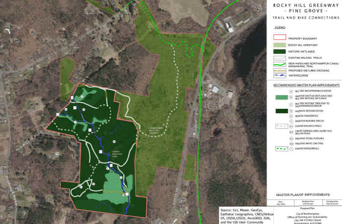
Note;
Just before you cross a bridge over Route 10, on your right will be the future
paved Rocky Hill Greenway. This trail will
take you Northwest, 0.5
miles to Rocky Hill Rd (Route 66). Scheduled for construction in 2025. See; Map Below, "green"
dotted Line.
You
cross over Route 10 at 2.9 miles via an iron enclosed bridge and head South. The open trail
now follows the transmission lines alongside Arcadia Wildlife Sanctuary.
Cross Lovefield St in Easthampton at 3.7 miles and parallel this street to the junction of
Lovefield & O'Neil streets. An iron bridge takes you over
the Manhan River. Look left to spot the stone embankments from the old RR
Bridge that used to cross here. The trail then comes to an intersection after
4.6 miles.
Note; Left, East,
the Manhan
Rail Trail travels out to Route 5. See Below.
Continuing straight, Southwest,
you'll cross Ferry St.
Note; Left, East,
a paved trail travels alongside Ferry St,
next to Lower Mill Pond, before quickly ending at the end of the pond.
An overlook is located
along your left. The trail then travels past Mill Side Park, along your left, which contains
restrooms and a parking lot. Along
your right are converted old mill buildings. The
trail travels alongside Mill Pond, where a couple of stone-dust
trails lead to overlooks of the pond and through an industrial area before coming to
Route 141 at 5.6 miles. A cross walk is here, but no cross light, so USE
CAUTION. Right up Route 141 takes you to Downtown Easthampton and Route 10. There are places to eat or grab some snacks.
A Map Board is located here next to a small pocket/sculpture park. Along the side
wall of the plaza is a giant mural that was created just for the bike trail,
showing the towns buildings and people. Opposite is the old Easthampton RR
Depot. Cross Payson Ave where you'll find a water fountain on your left. The trail then heads into a more shaded
section after passing between Rubber Thread Pond and Wilton Brook
Pond, with the Williston
Northampton School along your right. You pass through an old stone tunnel
underneath Park St. The trail then crosses South St
after 6.6 miles. Another Map Board located here. Nice wood fencing located
along this section which is wooded along the left and residential right. Pass by
an old cement RR Whistle Post on your right, before coming
crossing into Southampton. + See;
RR Whistle Post Below.
The
trail then ends after 7.3 miles at Coleman Rd.
Here you'll find a Map Board and bench area. Future plans
call for extending the trail South, through Southampton,
to connect into
Westfield's
Columbia
Greenway Rail Trail .
Hospital Hill Rail Trail Spur:
From the intersection with the Manhan/New
Haven & Northampton Canal Rail Trail [Southern
End]; This paved trail leads to Earle St, where
a cross-walk takes you over to
a wide sidewalk. Head right, North, to West St and cross street. Turn left,
West, uphill and
quickly come to the narrow paved Hospital Hill Rail Trail
Spur Loop on your right after 0.2 miles. This path heads
North, uphill past the Hospital
Sledding Hill on your right. Come to an intersection. Great views of the
valley from here. Head right along the paved trail as it travels through
the woods. Bear left at the intersection and come to a large Beach tree with a swing and an
intersection at 0.5 miles.
Note; Left leads up to the Northampton State Hospital Memorial Park,
which has an the old Hospital fountain and informational signs. Northampton State Hospital was a
historic psychiatric hospital on top of Hospital Hill. The hospital
building was constructed in 1856 and operated until 1993. The hospital was
originally known as the Northampton Lunatic Asylum.
Continuing straight you'll cross Olander Drive where the trail
heads into the forest at 0.6 miles.
Hiking trails past here. Return South, to Olander Drive and travel right up to the former Northampton State Hospital
site, which is now a residential development. Continue straight, South,
along Olander
Dr (residential) passing by the Northampton State Hospital Memorial Park.
As the road turns right, look left for the Hospital
Hill Rail Trail Spur Loop. This will
Loop you East,
back to the Hospital
Sledding Hill intersection. Turn right and head South,
back down to West St, where
you can return to the Manhan/New Haven & Northampton Canal Rail Trail
after about a 1.3 mile
Loop.
Manhan Rail Trail:
Starting from the Route 5 parking lot [Eastern
End];
A Map Board is located here. The paved Manhan
Rail Trail travels West,
past the power sub station
and then travels underneath I-91. You can see the part of the Connecticut River
known as the "Hook" because it breaks off from the main river
and forms a hook back towards Route 5. The trail also follows along the Manhan
River, for which the trail is named. After crossing over a small bridge, you will see an opening on your left in
the split rail fencing and a green bike rack at 0.8 miles. There will also be a sign that
reads "Old Pascommuck Conservation Area/Florence Smith Nature Trail". A set of wooden steps head
up to your right, but you head left down the path to the stone base of the
bridge. Standing next to the bottom of the stone stair abutment, with your back
to it, walk up a small knoll and spot 2 old railroad ties. Under the front railroad tie is
the Manhan Rail Trail Letterbox. Continuing along the trail, you'll pass
a small green sign to your right on the fence. This is the 1
Mile Marker. These Mileage Markers are placed
every mile along the right side of the trail (very
low to the ground). At 1 ¼
miles is the first of many old cement RR Whistle
Posts you will pass by. + See;
RR Whistle Post Below. Pass
by an old factory to your left,
that has been partially refurbished, before a sharp left brings you to the end of the trail at 2.3 miles.
This is where the Manhan/New Haven & Northampton Canal Rail Trail
intersects the Manhan
Rail Trail, traveling North,
to
Northampton and South,
to
Southampton. Map Board located here.
Old Railroad Equipment:
+
RR Whistle Post:
The Whistle Post,
was a post with a large "W" engraved or painted on it. This
meant the railroad engineers were to start sounding the trains Whistle.
The Whistle posts
were usually placed 0.25 miles
in advance of a road crossing,
bridges, tunnels and other points. Usually, there would be a post placed on both
sides of the crossing, covering both directions.
HH
CLICK
HERE FOR MAPS
CLICK
HERE FOR OLD MASS CENTRAL RR MAP
LETTERBOX LAST VERIFIED
ON
JUNE 29, 2025
TO EMAIL A VERIFICATION
bikeitorhikeitcontact@gmail.com
BEFORE YOU SET OUT BE SURE TO READ THE
WAIVER OF RESPONSIBILITY AND DISCLAIMER
BIKE IT OR HIKE IT
HOME PAGE