MASS CENTRAL RAIL TRAIL; BOSTON-CAMBRIDGE-BELMONT:
SOMERVILLE COMMUNITY PATH:
RED LINE LINEAR PATH:
FITCHBURG CUTOFF:
BOSTON-CAMBRIDGE-BELMONT, MASSACHUSETTS
-BIKE IT OR HIKE IT-
Last Updated: May 15, 2026
Length: Mass Central Rail Trail; Boston-Belmont; 5.8 miles.
Fitchburg Cutoff; 0.8 miles
Somerville Community Path/Red Line Linear Path; 5 miles
North Point Park; 0.3 miles
Difficulty: Fitchburg Cutoff; Easy. Flat, paved rail trail.
Somerville Community Path; Easy, mostly flat paved rail trail. Some hills along MBTA Green Line.
North Point Park: Flat paved trail.
Directions:
To start from Acorn Park Drive parking lot
in Cambridge [Western Section];
From
I-95, take exit 45 to Route 2 east to Alewife.
To start from Alewife T-Station "Hub" [Western Section]; From I-95, take exit 45 to Route 2 east to Alewife. Take the exit for Alewife Station Access Rd and park at the T-station's parking garage. Or take the subways Red-Line to access this station. See; MBTA for more information. For information about taking your bike on the subway. See; MBTA/BIKES .
To start from North Point Park in Cambridge [Eastern End]; On street parking (Fee). The Mass Central Rail Trail starts from the junction with the Charles River Bikeway. Or take the subways Green-Line to access the Science Park station, which is not far from the park. See; MBTA for more information. For information about taking your bike on the subway. See; MBTA/BIKES .
The Mass Central Rail Trail is a planned 104 mile trail from Northampton, East, to Boston. It will follow the old Central Mass Branch of the Boston & Maine RR that ran between the two cities. The railroad split into two after the1938 hurricane shattered the line. The trail today exists in many unconnected sections and with differing surfaces. Starting from Northampton heading East, the sections that are complete include the Mass Central Rail Trail; Norwottuck Branch, Mass Central Rail Trail: Belchertown , Mass Central Rail Trail; Ware River Valley Branch , Mass Central Rail Trail; Wachusett Greenway , Mass Central Rail Trail; Wayside Branch & Mass Central Rail Trail; Boston-Cambridge-Belmont . The Norwottuck Branch includes the towns of Northampton-Hadley-Amherst. The Ware River Valley Branch includes the towns of Ware-Hardwick-New Braintree. The Wachusett Greenway includes the towns of Barre-Rutland-Holden-West Boylston-Clinton. The Wayside Branch includes the towns of Waltham-Weston-Wayland-Sudbury-Hudson . For more information Check Out; MASS CENTRAL RAIL TRAIL .
In Northampton the Mass Central Rail Trail is a "Spoke" for 3 Trails.
In Cambridge at Alewife T- Station, a stop on the commuter rail line into Boston is a "Hub" for 5 Trails (plus interconnecting Trails).
Heading West the Mass Central Rail Trail; Boston-Cambridge-Belmont also known as the Fitchburg Cutoff, will eventually extend to Northampton.
Heading East the Mass Central Rail Trail; Boston-Cambridge-Belmont also known as the Red Line Linear Path, which becomes the Somerville Community Path, will bring you to North Point Park in Cambridge, where you may connect to the Boston Harborwalk; Charlestown and Charles River Bikeway .
Heading Northwest the Minuteman Bikeway brings you to Bedford, where you may connect to the Bedford Narrow Gauge Spur to Billerica and Reformatory Branch Rail Trail to Concord.
Heading Northeast the Alewife Brook Greenway brings you to the Mystic River, where you may connect to the Mystic River Paths in Somerville & Arlington.
Heading South the Fresh Pond Bike Path brings you to Fresh Pond, where you can access the Fresh Pond Loop Trail and continue Southeast, along the Watertown Branch Rail Trail to Watertown.
Starting from the junction with the Charles River Bikeway in North Point Park in Cambridge [Eastern End]; The Mass Central Rail Trail currently begins just East, of Education Circle and just West, of the North Bank Bridge and just South, of the Lynch Family Skatepark.
Future plans call for constructing a walkway South, alongside the Bascule Draw Bridge (look East) and across the river to Nashua Street Park. From there the trail will connect to North Station at TD Garden. This will be the starting point for the Mass Central Rail Trail. When the drawbridge is replaced, the bikeway will be constructed at the same time.
Note; From here, the Charles River Bikeway travels West, alongside the Charles River and East, up the North Bank Bridge to Revere Park, where you can connect to the Boston Harborwalk; Charlestown .
Heading Northwest along the paved Mass Central Rail Trail, you travel underneath the highway ramp, past the Lynch Family Skatepark on your right and out to and across Education St. Head left to Education Circle, then right alongside the road. There are lots of BLUEbikes locations along the route. Travel underneath the Gilmore Bridge to Morgan Ave. This brings you to Cambridge Crossing Park. For more information Check Out; CAMBRIDGE CROSSING . Here the trail continues alongside Morgan Ave.
Note; Paths wind through Cambridge Crossing Park along your right.
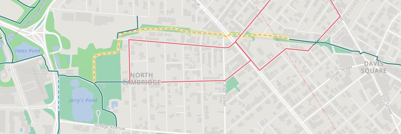
Cross N First St and look right to spot a water bottle filler before coming to Water St after 0.6 miles. Bear left where the trail follows the Somerville Community Path (part of the Mass Central Rail Trail) along the MBTA's Green Line Extension. After 0.9 miles you travel underneath a RR bridge before a bit of an uphill climb where you travel over a large rail yard & RR junction. This next section has very little shade. You'll travel back downhill, passing by the East Somerville Station at 1.4 miles. Spurs all along this section to access streets. Another small hill takes you up and across Walnut St at 2 miles. The trail now travels above the tracks below right. Cross Medford St and come to the Gilman Square Station at 2.2 miles. Cross School, Sycamore & Central Streets where the trail travels through a parking lot before passing by the small Somerville Junction Park. Travel underneath Lowell Ave at 2.8 miles. Here the trail no longer follows the rail line, but instead follows a flat, wide, shaded residential corridor. A jogging path also follows alongside the trail. Lots of artwork, micro-parks and gardens along this urban section. Come to a parking lot at 3.5 miles where the trail narrows a lot before crossing Grove St. Here the trail follows a double-wide sidewalk past the MBTA's Red Line Davis Station. Cross College Ave to Davis Square where there are outdoor tables, places to eat, and a Map Board. Davis Square can be very congested. Cross Holland St and a brick lined trail takes you past another Red Line Davis Station. Small park here with lots of artwork. This next section follows the paved Red Line Linear Path (part of the Mass Central Rail Trail) atop the Red Line.
Note; The Red Line Linear Path is being renovated in 2026 to include wider, newly paved trails with benches, drinking fountains, play spaces, public art, and bike racks. Expected completion Fall 2026. See; LINEAR PARK RECONSTRUCTION PROJECT .
You'll pass by a converted old brick building on your right and a trail circle on your left as you cross into Cambridge. Travel through Trolley Square, crossing Cameron Ave and Mass Ave at 4.2 miles. The urban trail is not as wide along this section. Cross Harvey St to Russell Field. Travel around the field to an intersection at 4.7 miles. BIKE STATION and water fountain located here.
Note; Straight will take you past the swimming pool, playgrounds and restrooms to the Russell Field Park parking lot off of Rindge Ave.
Turn right past the Red Line Alewife Russell Field Station and travel underneath the Alewife Brook Pkwy Bridge to the rear of Alewife Station and parking garage.
Note; Left, South, will take you along the Fresh Pond Loop Trail .
Head right, out to and across Alewife Station Access Rd. Travel left along the cantilevered boardwalk next to Yates Pond. This will bring you to the Alewife T-Station "Hub" at 5 miles. Spot the massive granite monoliths with the fish carvings.
Note; This is the start for the Minuteman Bikeway which travels North, passing by the start of the Alewife Brook Greenway; Northern Section which heads Northeast.
Cross Alewife Station Access Rd to the start of the Fitchburg Cutoff (part of the Mass Central Rail Trail).
Note; Heading North, will bring you to the Alewife Brook Greenway; Southern Section .
Cross the old RR bridge and follow the shaded, paved trail West, alongside Alewife Reservation. Quickly come to an intersection on your left.
Note; This paved trail leads to Cambridge park Dr.
Next you'll pass by the Alewife Brook Pathway on your right.
Note; A series of boardwalks and stone-dust trails traverse the marshes that drain off the Little River. See; Alewife Brook Greenway .
You'll pass a Map Board and second entrance for the Alewife Brook Pathway on your right. After 5.5 miles you come alongside the Fitchburg commuter rail tracks and follow them out to Brighton St in Belmont at 5.8 miles. Here the trail currently ends as of 2025. Construction slated to begin Fall 2026, will extend the trail West, through Belmont. See; Map Below.
Belmont Phase 1 construction.

Somerville Community Path/Red Line Linear Path; All construction complete:

HH
CLICK HERE FOR MASS CENTRAL RAIL TRAIL MAP
CLICK HERE FOR OLD MASS CENTRAL RR MAP
CLICK HERE FOR GREATER BOSTON BIKE NETWORK
BEFORE YOU SET OUT BE SURE TO READ THE
WAIVER OF RESPONSIBILITY AND DISCLAIMER
BIKE IT OR HIKE IT