MINUTEMAN BIKEWAY:
BEDFORD-NORTH CAMBRIDGE, MASSACHUSETTS
BEDFORD NARROW GAUGE SPUR:
BEDFORD-BILLERICA, MASSACHUSETTS
REFORMATORY BRANCH RAIL TRAIL:
BEDFORD-CONCORD, MASSACHUSETTS
ARLINGTON RESERVOIR LOOP TRAIL:
ARLINGTON, MASSACHUSETTS
-BIKE IT OR HIKE IT-
BEDFORD DEPOT PARK in Bedford is a "Hub" for 3 Trails (plus interconnecting Trails).
For more information visit; MINUTEMAN
BIKEWAY .
Reformatory Branch Rail Trail:
Last Updated: January 01, 2025
Length: Reformatory Branch Rail Trail; 3.9 miles
Difficulty: Moderate. Flat, hard packed dirt and gravel rail trail. Avoid after heavy rains. Mt bike recommended.
Directions:
To
start from the Bedford
Depot in
Bedford [Eastern
End]; From I-95,
take exit 49B to Routes 4 & 225 northwest for 1.9 miles and you’ll
come to Loomis St.
The Reformatory Branch Rail Trail follows a rail line built from Bedford West, to Concord in 1873 by the Boston & Lowell Railroad, later acquired by the Boston & Maine Railroad. Locals dubbed it the Reformatory Branch after it extended to Reformatory Station, next to a state prison, in 1879. In Concord you can check out the North Bridge, where the patriot militia stood down British soldiers in 1775.
Starting from Bedford Depot Park in Bedford [Eastern End]; Cross South Rd and travel West, 0.4 miles along Railroad Ave, to the Railroad Ave parking lot and actual start of the trail. Kiosk here. I haven't checked out this trail yet, as I was waiting for it to be improved. This trail was slated for improvement, but in 2022 the town voted it down. Unfortunate.
Bedford Narrow Gauge Spur:
Last Updated: January 01, 2025
Length: Bedford Narrow Gauge Spur; 3 miles
Difficulty: Easy. Flat, stone dust rail trail.
Directions:
From I-95, take exit 49B to
Routes 4 & 225 northwest for 1.9 miles and you’ll come to Loomis St.
To start from the Bedford Depot in Bedford [Southern End]; Turn left down Loomis St. Just before the intersection of South Rd, you will see where the trailhead begins on your right, at a metal gate. To your left is the Bedford Depot. The Minuteman Bikeway begins here as well.
To start from the Fawn
Lake
Conservation Area in
Bedford [Northern
End]; Continue past
Loomis St
and you’ll come to the Route 62 intersection. Route 4 turns right (also
called North Rd). Take Route 4 for 1 ½ miles and turn right onto Sweetwater Rd.
Travel a ½ mile and you’ll come to the parking lot along the right side, next
to where the trail crosses.
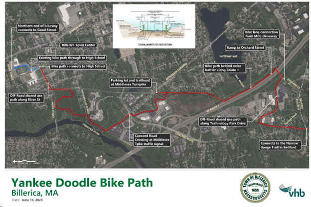
The Bedford Narrow Gauge Spur Trail follows the route of the Billerica & Bedford Railroad, built in 1877 with a narrow 2-foot-wide track to save money on construction costs. The company soon went bankrupt anyway, and in 1885 the Boston & Lowell Railroad used the corridor to build a standard-gauge railroad. The tracks went out of use in 1962. The trail travels North, from the Bedford Depot in Bedford to Billerica. The trail will soon continue North through Billerica, as the Yankee Doodle Bikeway.
Starting from the Bedford Depot in Bedford [Southern End]; Head back to Loomis St and cross over to the metal gate. The Bedford Narrow Gauge Spur Trail starts out paved as it travels North and has a small section of Narrow Gauge Track to highlight just how much narrower this railroad track was compared to regular gauge track. The paved section is only a ¼ mile long and ends at Routes 4 & 225. You cross over here to where the trail then turns to stone-dust. You cross Springs and Pine Hill Roads before passing by two water towers. A large stone retaining wall will then parallel the trail to your right. At this point keep an eye out to your left for a post with a trail Map and a sign posted to a tree.
Note; This is the York Conservation Area. It includes a hiking trail that comes out back on the trail further ahead.
Continue along the trail and pass by where the hiking trail reenters the Bedford Narrow Gauge Spur Trail. After 2 miles you pass through the Fawn Lake Conservation Area parking lot. A famous resort once stood near here, the Hotel Sweetwater. Its springs were thought to have medicinal benefits, and people traveled to the resort by train to bath in them. A marked walking path circles the pond. The trail then ends at a Springs Rd in Billerica after 3 miles.
Note; The Town of Billerica plans to connect the Bedford Narrow Gauge Spur Trail to the future Yankee Doodle Bikeway, extending the trail by 4 miles. Phase 1 will construct 1.5 miles with construction planned for Fall 2025. See; Map Below.
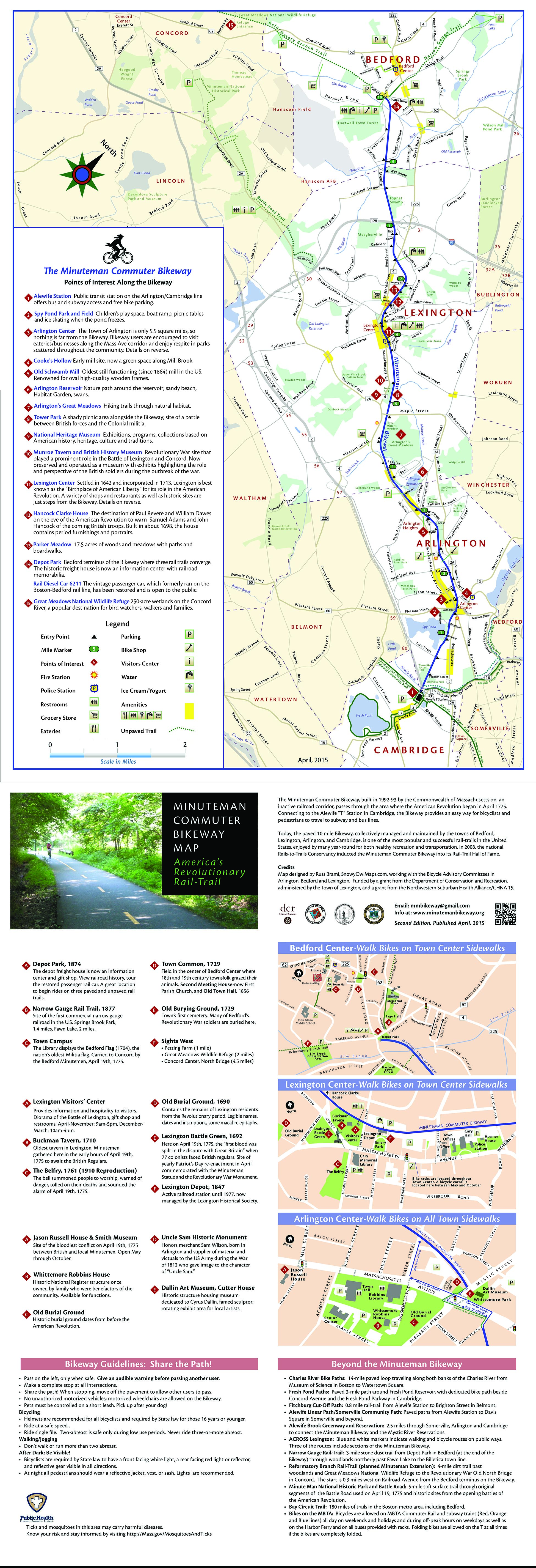
Minuteman Bikeway:
Last Updated: January 01, 2025
Length: Minuteman Bikeway;
10.1 miles.
Difficulty:
Easy. Relatively flat, paved rail
trail.
Directions:
To start from Bedford [Northern End]; From I-95, take exit 49B to Routes 4 & 225 (Bedford St) northwest for 1.9 miles. Turn left down Loomis St and follow to Bedford Depot Park on your left.
To start from Lexington
[Central
Section]; From I-95, take exit 49A to Routes 4 & 225 (
To start from Thorndike Field in
Arlington [Southern
Section]; From
I-95, take exit 45 to Route 2 east to Alewife. Follow the exit for Routes 3
& 16 northeast. Turn left onto Mass Ave
at the next intersection and continue for a ½ mile. Turn left on Lake St
and left on Margaret St. The parking lot is located at the end of the road, next to the trail.
To start from Alewife T-Station in Arlington
[Southern End]; Take Boston's
Red-Line to access this station. See; MBTA
for more information. For information about taking your bike on the subway.
See;
MBTA/BIKES . From I-95,
take exit 45 to Route 2 east to Alewife. Take the exit for Alewife Station
Access Rd and park at the T-Station's
parking garage.
The Minuteman Bikeway follows the former route of the Lexington & West Cambridge Railroad which traveled from North Cambridge Northwest, to Bedford. Built in 1846 and extended in 1874, the rail line was finally discontinued in 1981.
Starting from Bedford Depot Park in Bedford [Northwestern End]; Be sure to check out the old Bedford Depot Freight House, if it’s open. It has information on the history of the railroad and also sells some refreshments. Next to the Depot is an old Boston & Maine Railroad passenger car. Map Board located here. West, across South Rd, is the BIKEWAY SOURCE bike shop. Informational signs are located along the trail.
Note; From the Bedford Depot Park in Bedford, the Minuteman Bikeway is flat for the first 1.5 miles as it travels Southeast, followed by a slight upgrade for the next 2 miles to Lexington. From Lexington Southeast, it's a slightly downhill grade most of the rest of the way to Arlington. So if you are planning on biking up and back you would probably be better off starting from North Cambridge and getting most of the uphill grade out of the way.
As
you start out, the Minuteman Bikeway
will immediately pass by the former Bedford Railroad
Depot to your left, as it travels Southeast. After a ¼ mile, note the two old
RR Whistle Posts. + See;
RR Whistle Post Below. Granite Mileage
Markers every mile along the route. A cross light takes you over Hartwell Ave at 1.5 miles
where you travel alongside Tophet Swamp. Two miles takes you over I-95
via an old railroad trestle. Another cross-light over Route 4 at 2.7 miles.
Cross Hancock St in Lexington at 3.7 miles.
To your right is the
Lexington Common NHS. Pass by the Lexington Visitor Center and
the old Lexington Depot. A parking lot is located here.
Note;
You can take a quick detour here to check out the historic sights, such as Lexington
Common, the site of the first battle of the Revolutionary War. There
are also shops and restaurants. The Visitor
Center
has restrooms. You can also access the Battle
Road Trail from here by following Mass Ave West.
From Lexington the trail has a slight downhill grade. Travel underneath Route 2A at 5.2 miles and past Arlington's Great Meadows along your left. Cross Bow St and enter Arlington. After you travel underneath Drake Rd you'll pass by a Spur Trail on your left at 6.6 miles.
Note; This paved trail brings you North, to the Hurd Field parking lot. Here you'll find picnic tables, water fountain & Map Board, as well as, a narrow, 0.25 mile paved trail that Loops around the ball field. Off this Loop Trail is another paved Spur Trail that will take you up to the Arlington Reservoir Loop Trail after 0.1 miles. See Below.
Continuing Southeast, the trail has a few road crossings as it either travels over or under most roads. A few parks along the way. You'll pass by a BIKE STATION and the Arlington Visitor Center as you come to Mystic St at 8.6 miles. Look up at the overhead blue Minuteman Bikeway sign and it will show you how to navigate through town to continue along the trail. Head right out to Mass Ave. Shops and restaurants located here.
Note; Across Mystic St is Whitmore Park where you'll find some old RR tracks preserved along with the CYRUS DALLIN MUSEUM .
Cross Mass Ave and head left along a BIKE LANE for 1 block, then turn right on Swan Pl and you'll pick up the trail again under another blue Minuteman Bikeway sign. Travel past Spy Pond on your right where you'll find picnic tables, a path and playground. The trail then travels between the Thorndike Field parking lot on your right and Magnolia Park to your left. Continuing along the trail you'll pass by the entrance for the Alewife Brook Greenway on your left at 9.9 miles before traveling underneath Route 2. Look right across Alewife Station Access Rd to spot where the Alewife Brook Greenway heads West. Come to the Alewife T- Station "Hub" in Cambridge after 10.1 miles. Spot the massive granite monoliths with the fish carvings.
In Cambridge at Alewife T- Station, a stop on the commuter rail line into Boston is a "Hub" for 5 Trails (plus interconnecting Trails).
Heading West the Mass Central Rail Trail; Boston-Cambridge-Belmont also known as the Fitchburg Cutoff, will eventually extend to Northampton.
Heading East the Mass Central Rail Trail; Boston-Cambridge-Belmont also known as the Red Line Linear Path which becomes the Somerville Community Path, will bring you to North Point Park in Cambridge, where you may connect to the Boston Harborwalk; Charlestown and Charles River Bikeway .
Heading Northwest the Minuteman Bikeway brings you to Bedford, where you may connect to the Bedford Narrow Gauge Spur and Reformatory Branch Rail Trail.
Heading Northeast the Alewife Brook Greenway brings you to the Mystic River in Somerville, where you may connect to the Mystic River Paths .
Heading South the Fresh Pond Bike Path brings you to Fresh Pond, where you can access the Fresh Pond Loop Trail and continue Southeast, along the Watertown Branch Rail Trail to Watertown.
Arlington Reservoir Loop Trail:
Last Updated: January 01, 2025
Length: Arlington
Reservoir Loop Trail;
1 mile.
Difficulty:
Easy. Flat, stone-dust
trail.
Directions:
To start from the Arlington Reservoir
parking lot
Arlington [Eastern
End]; From
I-95, take exit 45 to Route 2 east towards Alewife. Take exit 133 to Park
Ave and head left, north, for 1.2 miles to Lowell St and turn left. parking lot
on your left.
In Arlington, a Spur Trail off the Minuteman Bikeway travels North, to the Arlington Reservoir Loop Trail. For more information visit; ARLINGTON RESERVOIR .
Starting from the Arlington Reservoir parking lot Arlington [Eastern End]; Heading South, the stone-dust Arlington Reservoir Loop Trail travels alongside the reservoir along a shaded corridor. Map Boards & informational signs located all along the route, along with granite Mileage Markers every 0.25 miles. Cross a spillway and come to an intersection.
Note; Left, South, a paved trail will bring you to Hurd Field where a narrow, 0.25 mile paved trail Loops around it. Right a wide, paved trail brings you past a Map Board, water fountain and picnic tables to the Hurd Field parking lot at 0.1 miles where you can also connect to the Minuteman Bikeway.
Continuing around the reservoir you cross another bridge and dam and pass by a fishing pier at 0.2 miles. Pass by Rindge Park on your left, which has a playground, before you come to a Map Board for ACROSS LEXINGTON (It is a network of marked trails and paths for walkers, runners and trail bikers. The routes use existing public ways to connect the town center with various historic sites, schools and conservation areas) at 0.5 miles. Come to Reservoir Beach at 0.7 miles.
Note; A gate blocks access to the beach.
Head right, along a narrow, hard packed dirt & grass trail that follows a causeway around Reservoir Beach. This brings you back to the Arlington Reservoir parking lot. Head right to complete your 1 mile Loop.
Old Railroad Equipment:
+
RR Whistle Post:
The Whistle Post,
was a post with a large "W" engraved or painted on it. This
meant the railroad engineers were to start sounding the trains Whistle.
The Whistle posts
were usually placed 0.25 miles
in advance of a road crossing,
bridges, tunnels and other points. Usually, there would be a post placed on both
sides of the crossing, covering both directions.
HH
CLICK HERE FOR MINUTEMAN BIKEWAY DETAILED MAP
CLICK HERE FOR MINUTEMAN BIKEWAY LESS DETAILED MAP
CLICK HERE FOR BEDFORD NARROW GAUGE SPUR MAP
CLICK HERE FOR REFORMATORY BRANCH RAIL TRAIL MAP
CLICK HERE FOR ARLINGTON RESERVOIR TRAIL MAP
CLICK HERE FOR ALEWIFE JUNCTION MAP
BEFORE YOU SET OUT BE SURE TO READ THE
WAIVER OF RESPONSIBILITY AND DISCLAIMER
BIKE IT OR HIKE IT