FARMINGTON CANAL HERITAGE TRAIL; NORTHERN SECTION:
FARMINGTON-MASSACHUSETTS BORDER
-BIKE IT OR HIKE IT-
Letterbox Planted: June 8, 2003
Last Updated: April 5, 2026
Length: Farmington Canal Heritage Trail; Northern Section; 24.4 miles
Meadow Road Trail; 1.7 miles
Difficulty: Easy. Paved flat rail trail.
Directions:
To start along the Meadow Road Trail in Farmington [Southeastern End] From I-84, take exit 39 and follow Route 4 east. Turn left off of Route 4 onto Route 10 south. Less then a mile on your right will be Meadow Rd. Go a short distance down Meadow Rd where an unpaved parking lot will be on your right just after crossing over a small river. This is the Conklin Nature Trail parking lot. There are two other parking lots further along this road if you wish to start closer to the start of the Farmington Canal Heritage Trail.
To start from the New Britain Ave parking lot in Farmington [Southern End]; From I-84, take exit 39 and follow Route 4 east. Turn left off of Route 4 onto Route 10 south. Less then a mile on your right will be Meadow Rd. Follow Meadow Rd to Red Oak Hill Rd to New Britain Ave. Take a right on New Britain Ave and the parking lot will be on your left. This is also the start of the Farmington River Trail.
To start from the Northwest Drive parking lot in Plainville [Southern End]; From I-84, take exit 39 and follow Route 4 east. Pass by the junction of Route 10 in Farmington and cross over the Farmington River. After 1.5 miles, take a right on Brickyard Rd and proceed about a mile. On your left will be a parking lot and the trail.
To start from Phelps Road near the CT/MA border in Suffield [Northern End]; From Routes 10 & 202 in Granby, CT, just over the line from MA, take Notch Rd east and immediately turn left onto Quarry Rd. Quarry Rd will travel east, then turn south. Turn left when you come to Phelps Rd. You'll travel underneath the trail and come to a small parking lot on your left. Map board, Bike Station and Porto-Potty located here.
The Farmington Canal Heritage Trail is a paved multi-use trail that extends from New Haven North, to the Massachusetts border. It follows the path of the former Farmington Canal and the New Haven & Northampton Railroad. Currently two sections are mostly complete in Connecticut. The Farmington Canal Heritage Trail; Southern Section runs from New Haven North, to Southington/Plainville and the Northern Section is complete from Plainville/Farmington North, to the Massachusetts border. A Gap currently exists, as of 2026, between the two Sections in Plainville. Plans are also in the works to connect the CT Fastrak Trail in New Britain West, to the FCHT in Plainville. See; DRAFT MAP . In Massachusetts the Canal continued North, to Northampton and was known as the Hampshire & Hampden Canal. The paved trail continues North, through Massachusetts following the rail bed of the former New Haven & Northampton RR. In MA, unlike CT, the trail sections all have different names as you cross town borders. The first section is called the Southwick Rail Trail in Southwick, followed by the Columbia Greenway Rail Trail in Westfield. A Gap currently exists, as of 2026, between the towns of Westfield & Southampton before the paved trail continues North, through Easthampton and Northampton along the Manhan/New Haven & Northampton Canal Rail Trail . The trail then intersects at the "Spoke" where the Mass Central Rail Trail; Williamsburg Branch travels Northwest, towards Williamsburg and the Mass Central Rail Trail; Norwottuck Branch which travels East, towards Amherst. For more information See; FARMINGTON CANAL HERITAGE TRAIL .
The Farmington Canal Heritage Trail is part of the EAST COAST GREENWAY , a planned biking & hiking route stretching 3,000 miles from Maine South, to Florida. When complete it will traverse 15 states with a mostly off-road path.
Encouraged by the success of the 363-mile Erie Canal and looking for ways to more effectively compete with the port of Hartford, a group of New Haven businessmen met to discuss the idea of a Canal route from New Haven to the Massachusetts border and beyond. Representatives from seventeen towns met in Farmington, CT in January 1822 and persuaded the legislature to issue a charter for the formation of the Farmington Canal Company. At about the same time the Hampshire & Hampden Canal Company was formed in Massachusetts to extend the Canal from Southwick, MA North, to the Connecticut River in Northampton. In 1828, the Farmington Canal opened for excursion boats to take passengers from New Haven to as far as Northampton, Massachusetts. The Canal was 86 miles long, 4 feet deep and 36 feet wide. Twenty-eight Locks were built in Connecticut to accommodate a 292 foot total drop in elevation along the Canal. The Canal was never profitable and so by 1848 commercial operations on the Canal ceased. The New Haven & Northampton Railroad Co. was chartered in 1846. Dubbed the “Canal Line,” the first section from New Haven to Plainville was completed in 1847, mostly along the route of the Canal. By 1850 the line had been completed from Plainville to the Massachusetts border. See; NH & NH RR .
The Farmington River Rail Trail is a paved spur trail off the Farmington Canal Heritage Trail; Northern Section which follows the abandoned Central New England Railroad line from Farmington North, to Simsbury, where it connects back to the Farmington Canal Heritage Trail; Northern Section. This trail is currently divided into two complete sections. The paved Farmington River Trail; Southern Section runs from Farmington North, to Canton, where an on-road connection will bring you to the stone-dust/paved Farmington River Trail; Northern Section in Simsbury, which travels Northeast, through Stratton Brook Park to Simsbury.
In Farmington, the Meadow Road Trail travels Northwest, alongside Meadow & Red Oak Hill Roads and connects to the Farmington Canal Heritage Trail; Northern Section and the Southern End of the Farmington River Rail Trail.
Meadow Road Trail:
Starting from the Conklin Nature Trail parking lot in Farmington [Eastern End]; The parking lot is next to the Pequabuck River, which flows into the Farmington River. I suggest you take a quick detour along the nature trail to where the rivers meet and check out the house up a small knoll across the river. Fabulous.
Note; Heading left, East, from the parking lot, the paved Meadow Road Trail crosses over an old stone arch bridge with views overlooking a marsh. We saw the biggest turtle I've ever seen outside of a zoo. If you continue East, the trail narrows and ends at Garden St (Route 10).
Heading right, West, from the parking lot, paved Meadow Road Trail is flat and soon travels along open farmland. At 0.4 miles you come to the Farmington Community Gardens and across the road is a 2nd parking lot next to where they fly radio controlled airplanes. Kids will love this. Meadow Rd veers left as the trail continues alongside Red Oak Hill Rd. After passing by a 3rd parking lot and then the entrance to Tunxis Mead Park at 1.1 miles the trail narrows and travels uphill. You'll come to the Farmington Canal Heritage Trail; Northern Section after 1.4 miles. If you continue straight along Red Oak Hill Rd, you come to New Britain Ave. Across this road is the start of the Farmington River Trail after 1.5 miles.
Farmington Canal Heritage Trail; Northern Section:
Starting from the Northwest Drive parking lot in Plainville [Southern End];
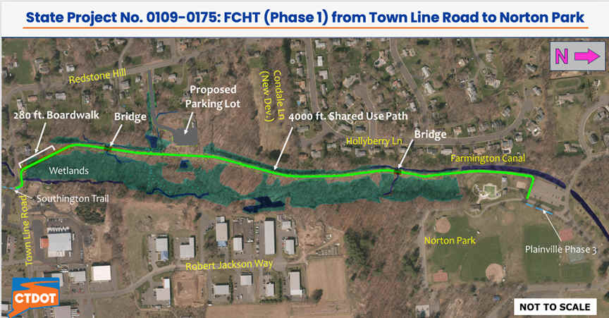
Note; As of 2026, a Gap exists North, from Southington through Plainville to Farmington, where you connect to the Farmington Canal Heritage Trail; Northern Section , as well as, the Farmington River Rail Trail . A short section is undeveloped in Southington from Aircraft Rd to Town Line Rd in Plainville. The Plainville section has been divided into 3 Phases. Phase 1, is currently under construction in 2026, will go from Town Line Rd to Norton Park and is planned to open Fall 2026. See; Map Below. Phase 3, is currently in the planning stage, as of 2026 and will go from Norton Park to Route 72. Phase 2, is scheduled to begin construction Fall 2026 and will continue from Route 72 to Northwest Dr in Farmington.
Click Here for Video of Plainville's 3 Phases of construction:
Note; The paved Northwest Drive Trail travels East-West from here. Heading West, the trail travels 0.8 miles to Route 177. Heading East, the trail travels 0.8 miles to Route 10, where you can connect to the paved Farmington Ave Trail which travels South, for 0.5 miles. The trail continues South, but is narrow.
The wide paved Farmington Canal Heritage Trail travels North, through Farmington alongside Johnson Ave up and over a slight rise bringing you out to and across Hyde Rd. The trail briefly follows Hyde Rd before heading north along a high berm out to Route 6 where a black metal bridge takes you over this busy road at 0.8 miles. You now travel along a open wooded corridor, passing by an old cement RR Whistle Post, + See; RR Whistle Post Below, before coming alongside New Britain Ave. You cross over the road at 1.9 miles and continue North, before the trail heads back into the woods. Pass by another old cement RR Whistle Post on your left before crossing Red Oak Hill Rd at 2.4 miles where you'll find a Map Board and the old trail 0 Mile Marker.
Note; Left, West, along Red Oak Hill Rd brings you to the start of the Farmington River Trail across New Britain Ave.
There are Mileage Markers every 0.5 miles along this section of the trail. The trail is flat and straight and well shaded, which is nice on a hot summer day. After 3.1 miles and just before the bridge over the Farmington River look to your right and you'll notice a gravel pullout and a small knoll. This is just before the start of a split rail fence. Facing this knoll, spot a two trunked Birch tree near the base of the knoll and a small Oak tree in the shape of a Y to the right. Next, look between these two trees for a Pine tree that resides on the opposite side of this knoll. Climb over the knoll to the Pine tree and at its base, under some branches and an old iron grill is the Farmington Canal Heritage Trail Letterbox. Continuing along the trail you cross a bridge high over the Farmington River. Fantastic views. After 3.5 miles you cross over Route 4 via a rebuilt railroad trestle bridge. To your right spot an old RR Siding that ran to an old brick building. Travel along a berm and down to your right will be a pond. You come to the Brickyard Road parking lot after 4.2 miles where you'll find another Map Board. An automatic cross-light gets you over Brickyard Rd. Soon, you'll cross over into Avon at 4.8 miles. After you pass through a marsh for Thompson Brook, the Thompson Road parking lot will be on your left at 5.5 miles. Keep a sharp eye out for remnants of the old rail line. I spotted old telephone poles and old RR Whistle Posts. Just after crossing over Scoville Rd at 6 miles an old RR Station will be on your right behind a high fence. This red stone station was built in the 1920’s by the founder of Avon Old Farms School and is used today for faculty housing; hence the fence. Cross Country Club Rd at 6.9 miles and Sandscreen Rd at 7.4 miles where you'll pass by a lumber yard. The trail then veers off the old rail bed at 7.7 miles next to the Town of Avon’s Public Works parking lot.
*Note; The old undeveloped rail bed continues North, crossing Arch Rd via an old RR bridge. It then continues along Old Farms Rd out to E Main Street (Route 44) where it disappears.
A short 0.25 mile on-road detour follows. There are green "Bike Route" signs leading the way. Pass through the parking lot and turn right down the access road. Cross Arch Rd where you'll pick up a paved trail alongside Security Drive. Here you'll encounter a long slight hill. When you reach Darling Drive the paved trail continues right downhill then left across a stone bridge over Nod Brook and through a tunnel underneath Route 44 where you'll emerge behind the rear parking area of the Avon Police and Town Hall at 8.4 miles. Continue straight, passing by Avon Village Center along your left. You are now on the site of the old Ensign-Bickford Company. These striking brownstone buildings were constructed by the Climax Fuse Company in 1884 and then acquired by Ensign-Bickford in 1907. Safety fuses were manufactured there until 1968. Today the buildings are used by the Town of Avon, a business park and the Farmington Valley Arts Center. Come to an intersection just before Market St (where you can access Avon Village Center) and turn right to Climax Heights Rd. This short on-road section crosses over a small Canal (Nod Brook) with old Gate Locks.
Note; If you would like to explore the old buildings take a left and proceed down a small paved path, passing by an old stone lantern. Paths and complex roads wind through the site.
The paved trail picks up again straight ahead across Ensign Dr. Head left alongside the Avon Green. There are shaded benches, a Veterans Memorial and a nice gazebo. The trail follows Ensign Dr to Fisher Dr (look up to your left for a nice view of Talcott Mountain and Heublin Tower) and out to Route 10 where a cross light brings you over to the Sperry Park parking lot 1 at 9.3 miles. BIKE STATION and Map Board located here. Next, you'll come to a T in the trail as you return to the old rail bed. Head left, North.
*Note; Right, South, takes you along the paved old rail bed for 0.2 miles before ending at Sperry Park parking lot 2. The old rail bed continues undeveloped out to Enford St Connector where it disappears out to E Main Street (Route 44).
You’ll now following a berm above the Nod Brook Wildlife Management Area. Great views of Talcott Mt. and Heublin Tower. Pass by an Avon/Simsbury town line marker at 9.8 miles. You cross over Route 10 at 10.5 miles (Use Caution, automatic flashing light but high speed traffic). Pass by the River Run parking lot on your left before crossing Latimer Lane at 11 miles. Pass by an old wooden RR Whistle Post on your left. Pass by Weatogue Park on your right before coming to Canal St after 11.8 miles. Head right to a series of cross-lights over Route 10 and Winslow Pl. Check out the bike sculpture. The trail continues along the old rail bed past the Winslow Pl parking lot where you'll find a Map Board. Cross Second Brook followed by Tamarack Lane at 12.4 miles. You then veer off the old rail bed at 12.8 miles up to Route 10, bypassing the Ensign-Bickford Munitions Company. The trail now travels alongside Route 10 and the Ensign-Bickford Munitions Company. You cross over Hop Brook, which flows through the Ensign-Bickford compound. Here, the trail travels up a small hill where you'll come to the first of two cross-lights over Routes 10 & 202 at the junction of Routes 10, 167 & 202. Continue straight to the second cross-light near the intersection of Drake Hill Rd at 13.6 miles. To your right is the historic JR Ensign House.
Note; You may access the Northern End of the Farmington River Rail Trail where it travels Southwest, through Stratton Brook State Park by crossing over Routes 10 & 202 and turning left along the paved trail. The trail then turns right and follows along the Northern Side of Route 167.
Continuing North, follow the trail right down Drake Hill Rd. You will see a bike route sign directing you to a cross-walk over Drake Hill Rd where the trail continues alongside Iron Horse Blvd.
Note; A quick detour of only a few hundred yards, by continuing straight along Drake Hill Rd, will bring you to the Bridge of Flowers. This is a pedestrian bridge (old road bridge) decorated with live flowering plants over the Farmington River. Picnic tables & water fountain are located here as well.
Continuing North, this section of the trail runs alongside Iron Horse Blvd in Simsbury Center. There are tons of parking lots along this section. This section also has green "period" lamp posts and historical markers explaining the areas railroad history. Pass by a water fountain and you'll come to a signpost that says Helens Way at 14.1 miles. Across the street you will see an old railroad station now converted into a restaurant along with an old red RR Caboose.
Note; For a short side trip you may proceed down Helens Way, which consists of a long wooden boardwalk, through the marshland of Drake Hill Park.
Just up the trail a bit further is the Rotary Park Playground. Kid heaven. You'll find a BIKE STATION off the trail here (air, tools...) next to a red bike sculpture. You then pass by the entrance for Simsbury Meadows parking lot. There is also a large amphitheatre here. The trail forks before reaching Route 10. Head right past the little plant island and bench at 14.7 miles. The trail now follows alongside the Simsbury Wildlife Management Area and Farmington River. You get a glimpse of the Farmington River as it bends near the trail. At 15.6 miles you pass by the Hop Meadow Street parking lot (Map Board) before a cross-light takes you over Tarriffville Rd.
Note; Future construction will create a paved trail East, alongside Tarriffville Rd (Route 315) to Curtiss Park.
Next comes a long straightaway across a berm through wetlands. The paved trail then crosses Wolcott Rd at 16.9 miles and travels over Munnisunk Brook with a scenic red barn to your right. Spot Lake Basile through the trees on your left as you come to the Lordship Road parking lot in East Granby at 17.4 miles. Right takes you to the Simsbury Tri-Town Airport. We saw a Bobcat here in June 2003. Here, the trail detours left, West, off the rail bed, bypassing the humungous Imperial Nurseries and bringing you out to Route 10. Turning right the trail follows Route 10 North, for a ways and then turns right, East, alongside Floydville Rd. After 18.9 miles the trail turns left back along the old rail bed. The trail travels past the nursery before entering the woods along a high berm. You cross over an old railroad trestle bridge high above Salmon Brook at 19.6 miles. If you look to your right, downstream, you can see Granbrook Park. You pass by the old Granby Railroad Station and then cross over Route 189 at 19.8 miles. Route 189 parking lot located here. Red tobacco sheds right. After heading back into the woods you'll come to Route 20 and a Map Board at 20.8 miles. Automated cross-light here. The Newgate Wildlife Management parking lot is located here. You head into deep woods along this ramrod straight trail and after 0.5 miles a Horse Path crosses the trail. After 22.3 miles you cross Copper Hill Road, where you'll find a parking lot. After crossing an old iron rail bridge you travel through Beaverdam Marsh and then through open farm fields in Suffield. Just before another iron rail bridge over Phelps Rd at 24 miles, a spur leads to the Phelps Road parking lot on your right. Map Board, BIKE STATION and Porto-Potty located here. The paved trail continues North, to the Massachusetts border at 24.4 miles, then continues into Massachusetts as the Southwick Rail Trail . The Southwick Rail Trail then becomes the Columbia Greenway Rail Trail when it crosses into Westfield.
Old Railroad Equipment:
+
RR Whistle Post:
The Whistle Post,
was a post with a large "W" engraved or painted on it. This
meant the railroad engineers were to start sounding the trains Whistle.
The Whistle posts
were usually placed 0.25 miles
in advance of a road crossing,
bridges, tunnels and other points. Usually, there would be a post placed on both
sides of the crossing, covering both directions.
HH
FARMINGTON CANAL HERITAGE TRAIL LETTERBOX LAST VERIFIED ON
JULY 04, 2025
TO EMAIL A VERIFICATION
bikeitorhikeitcontact@gmail.com
BEFORE YOU SET OUT BE SURE TO READ THE
WAIVER OF RESPONSIBILITY AND DISCLAIMER
BIKE IT OR HIKE IT