BORDER to BOSTON TRAIL; SOUTHERN SECTION:
NORTHERN STRAND COMMUNITY TRAIL:
EVERETT-MALDEN-REVERE-SAUGUS-LYNN, MASSACHUSETTS
-BIKE IT OR HIKE IT-
Last Updated: July 30, 2023
Length: Northern Strand Community Trail; 10.1 miles.
Difficulty: Northern Strand Community Trail; Easy. Flat paved rail trail.
Directions: For the Southern End of the Northern Strand Community Trail;
To start from the Gateway Center parking lot in Everett [Mystic River Path; North Side]; From the traffic circle and junction of Routes 16 & 99 follow Route 16 (Revere Beach Pkwy) west to a 2nd traffic circle. Take the Mystic View Rd exit alongside the Gateway Center. Take your second left into the Gateway Center parking lot and spot the reserved parking spots on your right for the trail. Green Map Board located here.
To start from the Encore Boston Harbor Casino in Everett [Mystic River Path; North Side]; From the traffic circle and junction of Routes 16 & 99 follow Route 99 (Broadway) south to the Casino. You can turn right into the Casino parking garage or left on Mystic St for exterior parking lots.
The Northern Strand Community Trail starts from the Mystic & Malden Rivers in Everett where it connects to the Lower Mystic River Path; North Side & Malden River Greenway; East Side next to the Gateway Center. You can park and start from the Gateway Center trail parking lot to the west or the Encore Boston Harbor Casino to the east. The trail travels North through Everett, Malden, Revere, Saugus and Lynn. It follows the rail bed of the former Saugus Branch RR. For more information visit; NORTHERN STRAND COMMUNITY TRAIL .
The Border to Boston Trail is an emerging 28-mile shared use trail linking eight communities from the New Hampshire border south to Boston’s North Shore. See; BORDER TO BOSTON TRAIL . The Northern Section consists of the Clipper City Rail Trail and Eastern Marsh Trail in Newburyport and Salisbury which are part of the Coastal Trails Network . A gap exists in Georgetown and Boxford where the trail is partially developed. The North Central Section travels through Topsfield, Wenham, Danvers and Peabody. The Border to Boston Trail; North Central Section; Topsfield Linear Common, Wenham Rail Trail, Danvers Rail Trail & Peabody Rail Trail follow the rail bed of the old Danvers & Georgetown RR which was chartered in 1851. In 1855 this line merged into the Newburyport RR and in 1860 it became part of the Boston & Maine RR/ Newburyport Branch. The Grand Wenham Canal may be accessed from the Topsfield Linear Common. In Peabody you connect to the Independence Greenway . Another gap exists to the Border to Boston Trail; South Central Section which consists of the Salem Bike Path, Marblehead Rail Trail, & Swampscott Rail Trail. Another gap exists to the Southern Section which consists of the Lynn Shore & Nahant Beach Reservation & Northern Strand Community Trail .
The Border to Boston Trail is part of the EAST COAST GREENWAY , a planned biking & hiking route stretching 3,000 miles from Maine to Florida. When complete it will traverse 15 states with a mostly off-road path.
Starting from the Southern End of the Northern Strand Community Trail:
A. Starting from the Encore Boston Harbor Casino entrance at Horizon Way & Broadway below the Encore sign in Everett [Mystic River Path; North Side]; Parking is located in the Casino parking garage or across Broadway. North of here you'll find a BLUEbikes STATION. See; HARBORWALK; ENCORE BOSTON HARBOR .
The brick pavers Mystic River Path; North Side travels Southeast around the Casino. Travel around a Garden circle and keep straight at an intersection. Lots of greenery. Keep straight at the next intersection. Come to the Mystic River side of the casino [Walk Bike when crowded]. Pass by an entrance to the Casino, where you'll find a Water Taxi dock. They did a great job with plantings (artificial grass). Follow the inlet out to the Mystic River, past a gazebo and come to a BLUEbikes STATION . Straight ahead is a RR bridge. Left a piece of land juts out to the river.
Note; A pedestrian bridge is scheduled to be built in 2024 that will cross the Mystic River and connect to Draw 7 Park in Somerville and the Lower Mystic River Path; South Side.
The paved trail continues North, past the casino, and traveling underneath the RR bridge to the rear of Gateway Center at 0.6 miles. Come to a tall blue sign where the Southern End of the Northern Strand Community Trail starts.
B. Starting from the Gateway Center parking lot in Everett [Mystic River Path; North Side]; Cross Mystic River Rd to an intersection and head left along the paved Lower Mystic River Path; North Side through Gateway Park. The path crosses back over Mystic River Rd where the trail travels right alongside the road. The trail then leaves the road and travels around an inlet to an intersection after 0.5 miles next to a tall blue sign. Left is the start of the Southern End of the Northern Strand Community Trail.
Northern Strand Community Trail:
Starting from the Southern End of the Northern Strand Community Trail & the junction of the Lower Mystic River Path; North Side in Everett; [Re-zeroing Mileage] Tall blue sign. The wide, paved Northern Strand Community Trail travels North along the old rail bed between Gateway Center and the RR tracks. Pass by a Map Board as you leave the Gateway Center behind. Travel underneath the Route 16 bridge and come to Wellington Ave and another Map Board at 0.8 miles. Follow a residential/industrial corridor. You'll pass by tennis courts at Rosetti Park before coming to a Map Board & water fountain at 1.3 miles. BLUEbikes STATION located just up the trail. Across Air Force Rd on your left is Rivergreen Park parking lot.
Note; You can access the Malden River Greenway; East Side in Rivergreen Park.
Continuing you cross into Malden and pass by Bell Rock Cemetery before coming to Medford St at 1.9 miles where you'll need to turn left to reach a cross-light. The trail travels alongside Canal St, where you'll find another Map Board and information about the EAST COAST GREENWAY . The trail veers Northeast and brings you to Main St at 1.6 miles. Turn left to access a cross-light. The urban trail now travels through Malden. At Ferry St, again turn left to access a cross-light. A series of cross-lights will take you left over Route 60 where the trail continues to your right along an open industrial corridor. Several small street crossings. Pass by a community garden at 3.2 miles. Cross Broadway at 4 miles and a side trail on your right leads to a CVS. Cross Beach Street at 4.8 miles where you'll pass by a parking lot. Cross Lynn and Wesley streets at 5 miles where you travel along the open Revere Section. Travel underneath Route 1 and your rewarded with scenic views of Rumney Marsh. Cross Salem St at 5.7 miles as the trail turns North. Travel past a Map Board and into a residential, tree lined corridor. You enter Saugus next to a spur to Laurel St at 6 miles. Cross Eustis St and spot the old 1853 Cliftondale RR Station on your right. Pass by Parker Playground before a series of cross-walks take you over Essex & School Streets. Cross Adams Ave at 6.7 miles and as you pass by the playing fields of Belmonte Saugus Middle School look right to spot an old cement RR Whistle marker. After crossing Denver St pass an old RR Mileage Marker that has an R on it (Revere?). The trail turns East before crossing Central St, where you can access shops. The trail follows the Shute Brook along your right then travels along a causeway between the Shute Brook floodplain on your right and the Saugus River floodplain to your left. Very scenic. Cross a red iron arched bridge (replaced the old RR bridge) over the Saugus River before crossing Lincoln St at 8.5 miles. Marshview Park is on your right and overlooks the Saugus River floodplain. Flight path for Logan Airport here. Map Board. Blue signs indicate the street your crossing. The trail crosses into Lynn along another causeway next to the Saugus River on your right and Beaver Brook to your left. Nice overlook here. Cross light over Summer St followed by Cottage St at 9.4 miles where you'll find a very cool playground built along the trail. Community garden just before crossing Spencer St. Come to *Western Ave at 9.7 miles.
Note; Future construction in 2023 from *Western Ave will extend the trail 2 miles through Lynn to Nahant Beach where you'll be able to connect to the Lynn Shore & Nahant Beach Reservation Trails . See; Lynn Spur Below.
The trail follows the old rail bed South, crossing Summer St, where a berm brings you up to the end of the trail at 10.1 miles. Here, an old double RR bridge crossed Bennett St, where the old RR joined an active RR line.
Lynn Spur:

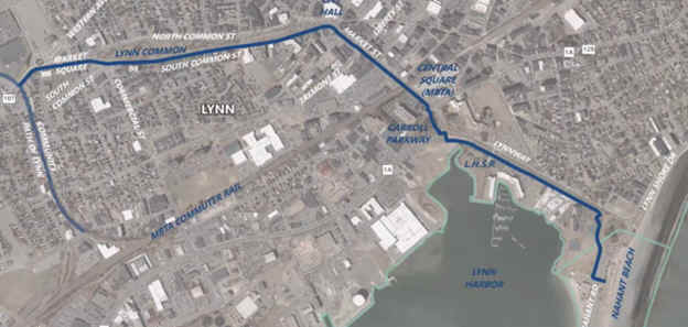
[The project would build new two-way, curb-separated bike lanes along the south side of the Market Square roundabout (pictured above), the Lynn Common, and Market St]
Current Detour along the Lynn Spur; Starting from *Western Ave; You'll need to travel left on-road along Western Ave to the Market Square roundabout. Take your second right on Market Square to Common St (Lynn Common is located between North & South Common Streets which are one-way). Here you can follow the paved Lynn Common Path which travels East along both the North and South Sides of the greenspace and starts at the beginning of the Common at 0.2 miles. The Path follows South Common St heading east. Pass by a gazebo and restrooms before crossing Hannify Square where the Common narrows. Look right to spot the old brick Lynn Armory. After 0.8 miles you'll exit the Common. Pick up a BIKE LANE along S Common St at 0.8 miles. Turn right along Market St where the BIKE LANE continues. Come to Broad St after 1.2 miles. Past here it's on-road until construction begins. Come to the Lynnway and head left on-road (sidewalk available). You'll pass by Lynn Heritage State Park at 1.4 miles. Come to the Lynn Shore Dr/Nahant Rd Rotary. Follow around to Lynn Beach where you'll pick up the Lynn Shore & Nahant Beach Reservation Trails after 1.9 miles.
HH
BEFORE YOU SET OUT BE SURE TO READ THE
WAIVER OF RESPONSIBILITY AND DISCLAIMER
BIKE IT OR HIKE IT