INDEPENDENCE GREENWAY;
PEABODY, MASSACHUSETTS
-BIKE IT OR HIKE IT-
Last Updated: October 26, 2025
Length: Independence Greenway; Western Section; 2.9 miles
Independence Greenway; Eastern Section: 1.5 miles
On-road Eastern & Western Sections Connector; 1.5 miles
Difficulty: Easy. Flat, paved rail trail.
Directions:
To start from the Russell Street parking lot [Western End]; From Route 1 take the Lowell St exit and travel west. After 0.8 miles bear right on Russell St. Just before the end of the road at Boston St look left for the parking lot across from the trail head.
To start from Lt. Ross Park parking lot [Central Section]; From Route 1 take the Lowell St exit and travel west. When the road splits bear left on Johnson St. Just before you cross over a bridge turn left into Lt. Ross Park. A small street sign marks the entrance.
The Independence Greenway follows the rail bed of the Salem & Lowell Railroad, which was a branch line of the Boston & Lowell Railroad and ran off the Essex Railroad in Peabody to Tewksbury where it met the Lowell & Lawrence Railroad at Tewksbury Jct. The line was chartered in 1848 and opened in 1850. The Independence Greenway; Eastern Section travels from the Middleton border Southeast, through West Peabody to I-95 and Route 1 where a Gap exists, because of these highways. An on-road connection then bypasses the highway and connects to the Independence Greenway; Western Section in Peabody, where it continues East. Between the Eastern & Western Sections you can connect to the Southern End of the Peabody Rail Trail, part of the Border to Boston Trail; North Central Section . See; INDEPENDENCE GREENWAY .
The Border to Boston Trail is an emerging 28-mile shared use trail linking eight communities from the New Hampshire border South, to Boston’s North Shore. See; BORDER TO BOSTON TRAIL . The Northern Section consists of the Clipper City Rail Trail and Eastern Marsh Trail in Newburyport and Salisbury which are part of the COASTAL TRAILS COALITION . A Gap exists in Georgetown and Boxford where the trail is partially developed. The North Central Section travels through Topsfield, Wenham, Danvers and Peabody. The Border to Boston Trail; North Central Section; Topsfield Linear Common
North Central Section; Topsfield Linear Common, Wenham Rail Trail, Danvers Rail Trail & Peabody Rail Trail follow the rail bed of the old Danvers & Georgetown RR which was chartered in 1851. In 1855 this line merged into the Newburyport RR and in 1860 it became part of the Boston & Maine RR/ Newburyport Branch. The Grand Wenham Canal may be accessed from the Topsfield Linear Common. In Peabody you connect to the Independence Greenway . Another Gap exists to the Border to Boston Trail; South Central Section South Central Section which consists of the Salem Bike Path, Marblehead Rail Trail, & Swampscott Rail Trail. Another Gap exists to the Southern Section which consists of the Lynn Shore & Nahant Beach Reservation & Northern Strand Community Trail .The Border to Boston Trail is part of the EAST COAST GREENWAY , a planned biking & hiking route stretching 3,000 miles from Maine South, to Florida. When complete it will traverse 15 states with a mostly off-road path.
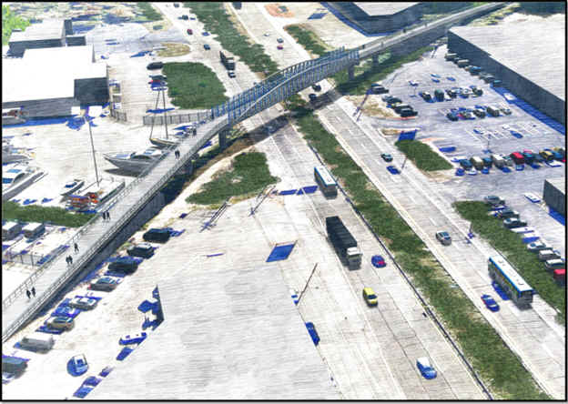
Note; As of 2025, there is a Gap between the Eastern and Western Sections of the trail. Designs are in the works to complete this Gap, including a new pedestrian bridge over Route 1. Construction scheduled for 2026. See Map Below.
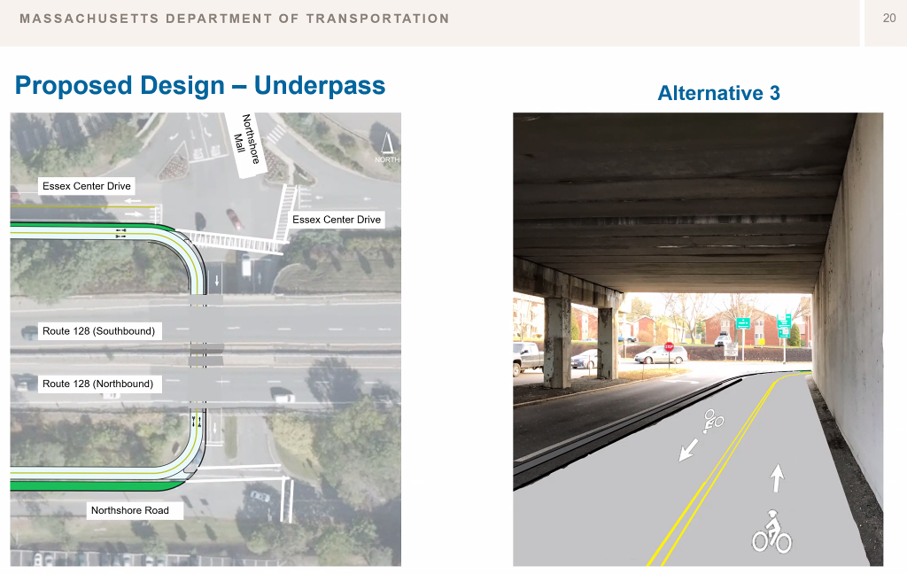
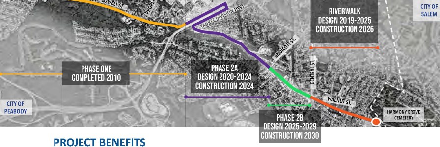
The Map Below shows the two existing sections of the Independence Greenway on either side of I-95 in Peabody. The green-dashed line is the route of the current project to extend the trail from Lahey Medical Center East, across Route 128, to Endicott St with a separated shared-use path. Construction slated for 2025. The red dots represent the current Gap, which is currently in design and slated for construction in 2026.

Independence Greenway; Western Section:
Starting from the Russell Street parking lot in West Peabody [Western End]; Cross Russell St to a Map Board. Maps & informational signs all along the trail. The paved Independence Greenway; Western Section travels East, through the woods and along the Ipswich River. After 0.6 miles the trail opens up as you follow a power line. A causeway crosses the Norris Brook Wetlands at 1.5 miles. Cross Russell St and enter a commercial corridor before crossing Lowell St at 2.2 miles. This brings you to a bench overlooking Crystal Pond on your left. At the edge of the pond are two headstones that describe the deceased as having been accused of witchcraft. Enter the woods, then cross a causeway between a large marsh. The trail travels underneath Johnson St where it turns North, off the old rail bed.
Note; The old rail bed is now blocked by I-95, requiring an on-road detour.
This brings you to the Lt. Ross Park parking lot at 2.9 miles.
Independence Greenway; Eastern & Western Sections on-road Connector:
Note; As of 2025, there is a Gap between the Eastern and Western Sections of the trail. Designs are in the works to complete this Gap, including a new pedestrian bridge over Route 1. Construction scheduled for 2026. See Map Below.
[Re-zeroing Mileage] This Connector is on-road (narrow sidewalks available) and is not recommended for kids on bikes. From the Lt. Ross Park parking lot; Head North, out the entrance to Johnson St and turn right. Traffic along this road is medium to low. There is no shoulder and a narrow sidewalk. Bear right, East, along Lowell St, a high volume road. Again, a narrow sidewalk is available, however, a better sidewalk is available on the opposite side of the street. A slight hill takes you up past the Route 1 on-ramp then downhill where you travel underneath Route 1. Along the right side of Lowell St there is no sidewalk or shoulder. I recommend utilizing the left side of the street which has a sidewalk.
Note; Just before you travel underneath I-95after 1 mile look left to spot a bench. Here, the Peabody Rail Trail heads North, through a tunnel underneath I-95. See; Border to Boston Trail; North Central Section.
After traveling underneath I-95 you'll pass by the Temple Bethel Cemetery. A narrow sidewalk runs along the right. Turn right, South, down Peabody Rd. This is a residential road. After you cross over a culvert you'll come to the Independence Greenway; Western Section after 1.5 miles.
Independence Greenway; Eastern Section:
Starting from Peabody Road; [Re-zeroing Mileage] The paved Independence Greenway; Western Section travels East, along the old rail bed. The trail follows Proctor Brook and a small marsh along your left. You come alongside Lowell St for a bit before traveling along Marble Meadows Conservation Area. At 1 mile the trail utilizes the sidewalk along Lowell St. Use the cross-light to cross Prospect St, then turn left and use the cross-light to cross Lowell St back to the paved trail. The trail travels behind residential backyards before ending at the Lehey Clinic parking lot after 1.5 miles, next to Route 128. If you continue straight along the road you'll come to the North Shore Mall.
Note; Future construction will extend the trail Northeast, where you'll travel underneath the Yankee Division Hwy (Route 128), then Southwest, back to the old rail bed. Here the trail will continue East, along Proctor Brook to downtown Peabody. Slated for construction in 2025. See; Maps Below.
HH
CLICK HERE FOR PEABODY GREENWAYS MAP
CLICK HERE FOR BORDERS TO BOSTON MAP
BEFORE YOU SET OUT BE SURE TO READ THE
WAIVER OF RESPONSIBILITY AND DISCLAIMER
BIKE IT OR HIKE IT