BORDER TO BOSTON TRAIL; SOUTH CENTRAL SECTION:
MARBLEHEAD RAIL TRAIL:
MARBLEHEAD, MASSACHUSETTS
SALEM BIKE PATHS:
SALEM, MASSACHUSETTS
SWAMPSCOTT RAIL TRAIL:
SWAMPSCOTT, MASSACHUSETTS
-BIKE IT OR HIKE IT-
Last Updated: October 27, 2025
Length: Marblehead Rail Trail; Salem Spur; 1.5 miles
Marblehead Rail Trail; Swampscott Spur; 2.1 miles
Swampscott Rail Trail; 0.3 miles
Marblehead Neck Loop; 5.1 miles
Salem Bike Path; 1.8 miles
Washington Street Bike Lane; 0.4 miles
Salem Bike Loop; 2.5 miles
Salem Willows Park Loop; 2.3 miles
North River Canal Walkway Loop; 0.9 miles
Difficulty: Marblehead Rail Trail; Easy. Flat, stone dust rail trail.
Swampscott Rail Trail; Easy, Flat, stone-dust rail trail.
Marblehead Neck Loop; On-road.
Salem Bike Path; Easy. Flat, paved rail trail.
Salem Bike Loop; Easy. Mostly flat, paved trail w/some on-road & Bike Lane sections.
Salem Willows Park Loop; Moderate. Mostly flat w/a couple of hills and some on-road sections.
North River Canal Walkway Loop; Easy. Flat paved trail
Directions:
To start from Roundhouse Road parking lot in Marblehead for the Marblehead & Swampscott Rail Trail [Central Section; Eastern End]; From Route 128 take exit 39 to Lowell St and travel east towards Salem. Continue straight on Main St then Boston St. Turn right on Essex St then left on Jackson St. Follow to Jefferson Ave and turn right. Follow to traffic circle and turn left, then bear right on Loring Ave. Turn right on Lafayette St (Route 114) and follow into Marblehead. Continue straight on Pleasant St for 0.7 miles, then take a left onto Bessom St. There will be a public parking lot on your right on Roundhouse Rd. The trail starts left across the street at the yellow cable.
Note; MARBLEHEAD CYCLE is just up Bessom St.
The Border to Boston Trail is an emerging 28-mile shared use trail linking eight communities from the New Hampshire border South, to Boston’s North Shore. See; BORDER TO BOSTON TRAIL .
The Border to Boston Trail; Northern Section starts from the NH border and travels South and consists of the Eastern Marsh Trail in Salisbury and the Clipper City Rail Trail in Newburyport, which are part of the Coastal Trails Network . See; COASTAL TRAILS COALITION . A Gap exists South, along the Byfield Rail Trail in Byfield, Georgetown Rail Trail in Georgetown and Boxford Rail Trail in Boxford. These trails are mostly still undeveloped. They all follow the rail bed of the old Danvers & Georgetown RR which was chartered in 1851. In 1855 this line merged into the Newburyport RR and in 1860 it became part of the Boston & Maine RR/Newburyport Branch.
Note; From the future Georgetown Rail Trail, when complete, you'll be able to access an old Rail Spur Line that traveled Northwest, that includes the Groveland Community Trail in Groveland & Bradford Rail Trail in Bradford. Also, across the Merrimack River, you can access the Brian S. Dempsey Haverhill Riverfront Boardwalk in Haverhill.
The Border to Boston Trail; North Central Section continues South and consists of the Topsfield Linear Common in Topsfield, the Wenham Rail Trail in Wenham, the Danvers Rail Trail in Danvers & the Peabody Rail Trail in Peabody. They all follow the rail bed of the old Danvers & Georgetown RR which was chartered in 1851. In 1855 this line merged into the Newburyport RR and in 1860 it became part of the Boston & Maine RR/Newburyport Branch. Also, in Peabody, the Border to Boston Trail utilizes the Eastern Section of the Independence Greenway as it travels Southeast. Currently a Gap exists between Peabody and Salem.
Note; From the Topsfield Linear Common you can access the Grand Wenham Canal Loop Trail to the East and from the Danvers Rail Trail you can access an old Rail Spur Line that traveled Northwest, that includes the Danvers Rail Trail; Northern Extension in Danvers & Middleton Rail Trail in Middleton. Also, from the Southern End of the Peabody Rail Trail in Peabody you can access the Western Section of the Independence Greenway as it travels Northwest.
The Border to Boston Trail; South Central Section continues South and consists of the Salem Bike Path in Salem and the Marblehead Rail Trail; Salem Spur in Marblehead which travels East. Then, traveling South, the Marblehead Rail Trail; Swampscott Spur & Swampscott Rail Trail in Swampscott. The Salem Bike Path & Marblehead Rail Trail; Salem Spur follow the rail bed of the old Eastern Railroad Company Line built in 1839. The Marblehead Rail Trail; Swampscott Spur & Swampscott Rail Trail follow the rail bed of the old Eastern Railroad Company Line built in 1873. Currently a Gap exists South, in Swampscott.
The Border to Boston Trail; Southern Section continues Southwest and consists of the Lynn Shore & Nahant Beach Reservation and traveling West, the Northern Strand Community Trail .
The Border to Boston Trail is part of the EAST COAST GREENWAY , a planned biking & hiking route stretching 3,000 miles from Maine South, to Florida. When complete it will traverse 15 states with a mostly off-road path.
Border to Boston Trail; South Central Section:
The two trails that make up the Marblehead Rail Trail are abandoned railroad lines of the Eastern Railroad Company. The Salem Spur follows a line built in 1839 from Marblehead towards Salem. In Salem it becomes the Salem Bike Path, also known as the Mayor Anthony V. Salvo Bike Path. The Swampscott Spur follows a line built in 1873 from Marblehead towards Swampscott where it becomes the Swampscott Rail Trail. The lines were abandoned in 1959. Both trails start from the Roundhouse Road parking lot before splitting off just up the trail. See; SWAMPSCOTT RAIL TRAIL for more information.
Marblehead Rail Trail; Swampscott Spur & Swampscott Rail Trail:
Starting from the Roundhouse Road parking lot in Marbletown [Central Section; Eastern End]; Pass through the yellow gate and follow the stone-dust Marblehead Rail Trail West, underneath the Village Street Bridge. You come to an *Intersection by an electrical station after 0.2 miles.
Note; Right, the Marblehead Rail Trail; Salem Spur connects to the Salem Bike Path.
Head left past the sub-station. This section of the Marblehead Rail Trail; Swampscott Spur travels South, along a residential corridor and crosses Maverick St followed by Pleasant Street at 0.6 miles. Cross-walk, however, Use Caution as this is a well traveled road.
Note; See; Marblehead Neck Loop Below for an on-road route around Marblehead Neck from here.
After crossing Smith St you'll pass by Marblehead High School. At 1.6 miles the trail continues straight utilizing a paved driveway past Temple Emanu-El out to Clifton Ave. Across Clifton St the trail is partially developed consisting of a narrow hard packed dirt surface. Cross Rockaway Ave and after 1.9 miles you'll pass a side trail on your right leading to the Ware Pond Conservation Area. Look left to spot some old cement RR Rail Holders. + See; RR Rail Holders Below. Come to Seaview Ave at 2.1 miles where you enter Swampscott and the stone-dust Swampscott Rail Trail continues. Several residential street crossings before you come to Bradlee Ave at 2.4 miles and the end of the trail. Future plans will continue the trail South.
Marblehead Rail Trail; Salem Spur & Salem Bike Path:
Starting from the Roundhouse Road parking lot in Marbletown [Central Section; Eastern End]; Pass through the yellow gate and follow the stone-dust Marblehead Rail Trail West, underneath the Village Street Bridge. You come to an *Intersection by an electrical station after 0.2 miles.
Note; Left, the Marblehead Rail Trail; Swampscott Spur connects to the Swampscott Rail Trail.
Head right past the sub-station. This section of the Marblehead Rail Trail; Swampscott Spur follows an open corridor West, along a power line. Pass by the hiking trails of the Hawthorn Pond Conservation Area followed by Tower School before coming to W Shore Dr at 0.8 miles. Cross-walk, however, Use Caution as this is a busy road. You now pass through Wyman Woods Conservation Area. Travel alongside Salem Harbor and across a bridge over the Forest River before coming to Route 114 in Salem at 1.5 miles. Turn right to access a cross-walk over this very busy road. USE CAUTION. This is the start of the paved Salem Bike Path, along known as the Mayor Anthony V. Salvo Bike Path. This residential corridor travels North, past Jackman Field, where you'll find a spur trail on your left that leads to an overlook of the Old Creek Salt Marsh. You then travel past Salem State University before a cross-walk over busy Loring Ave. BLUEbikes located here. Nice trail lampposts and benches. Cross Canal St at 2.2 miles where the trail follows an industrial corridor and soon parallels active RR tracks. Here the trail travels between the RR tracks and Canal St bringing you to Mill & Washington Streets after 3.3 miles. BLUEbikes located here. To continue into Salem cross Washington St on your right and follow the Washington Street BIKE LANE heading left, North. Come to *New Derby Street at 3.4 miles.
Note; Heading right, will take you along the Salem Bike Loop. This Loop will return you here via the Washington Street BIKE LANE heading South. See Below. You can also access the Salem Willows Park Loop from the Salem Bike Loop. See Below.
Continuing North, along the Washington Street BIKE LANE takes you through downtown Salem. You'll pass by Essex St on your right which is a pedestrian only walkway. Come to Bridge St after 3.7 miles. From here you can access the North River Waterfront Loop. See Below. The Salem Bike Loop also comes in from your right utilizing the Washington Street BIKE LANE, South back to the Salem Bike Path.
Salem Bike Loop:
Starting from the intersection of the Washington Street BIKE LANE & *New Derby Street; Head East, along the New Derby Street BIKE LANE. Lots of places to eat. Cross Lafayette St and continue along the Derby Street BIKE LANE. Quickly come to the start of the Salem Harborwalk Loop on your right. Spot the EAST COAST GREENWAY sign.
Note; You can do a quick detour along the Salem Harborwalk Loop and return back here. Follow the cement Salem Harborwalk Loop south to an inlet for Salem Harbor. Informational signs. Travel to the South Side and follow the trail East, alongside the harbor out to Congress St. Head left back across the harbor to the North Side. Short set of stairs leads to pea stone which quickly takes you along a boardwalk west. Travel past Charlotte Forten Park on your right along the cement trail before retuning to the end of the harbor. Turn right and return to Derby St after a 0.3 mile Loop.
Continuing East, along the Derby Street BIKE LANE you cross Congress St/Hawthorne Blvd. Come to the SALEM MARITIME NATIONAL HISTORIC SITE on your right after 0.4 miles. Here you'll find a NPS Visitor Center w/restroom along with a map of Salem.
Note; You can do 2 quick detours from here. The Central Wharf Causeway starts past the NPS Visitor Center heading South, along a stone-dust path. Ends after 0.1 miles. Head along Derby St to the next wharf. Here the Derby Wharf Causeway travels South, along a stone-dust path. You pass by the Friendship of Salem, a replica of the original merchant ship. The path then becomes gravel, making for a moderate bike ride. The causeway brings you out to the black & white 1871 Derby Wharf Light Station at 0.3 miles.
Continuing East, on-road along Derby St (no more BIKE LANE, but one-way w/slow traffic) are shops and historic houses. Quaint. Come to **Webb Street at 0.8 miles.
Note; From here you can do a detour along the ***Salem Willows Park Loop. See Below.
Across Derby St you'll pick up the paved Peter F. Tracy Walkway as it travels West, through David J. Beattie Park. Small parking lot here. Cross Fort Ave and Szetela Lane brining you to Collins Cove at 1 mile.
Note; The Salem Harbor Connector Path starts on your right heading North. This is also where the ***Salem Willows Park Loop returns.
The trail continues West, along the Southern End of Collins Cove. Come to Collins St and Collins Cove Beach.
Note; If you head right, up Collins St, it will bring you to Collins Cove Park (playground & sports fields).
Head left across Collins St (cross-walk) where the Peter F. Tracy Walkway continues East, alongside Webb St before Bridge St. The trail then travels through a residential corridor which brings you out to the Sergeant James Ayube Memorial Drive Trail after 1.4 miles.
Note; This trail continues North, alongside Sergeant James Ayube Memorial Drive below left. It quickly ends after 0.2 miles at Skerry St.
Head left along the Sergeant James Ayube Memorial Drive Trail as it travels South, alongside Sergeant James Ayube Memorial Dr. This brings you to Bridge St at 1.7 miles. Cross Bridge St and head right, North, on a narrow paved path back alongside Sergeant James Ayube Memorial Dr. This brings you to a circle with benches in the middle. Travel around this circle and continue South, alongside some RR tracks. The North River is on the opposite side of the tracks. You'll travel past the Salem Train Station where the path follows a narrow sidewalk back out to Bridge St. Head right, on-road (sidewalk available) to the Intersection of Washington & Bridge Streets at 2.2 miles.
Note; To check out the North River Waterfront Loop. See Below.
Head left, South, along the Washington Street BIKE LANE as it travels through downtown Salem. This returns you to *New Derby Street after a 2.5 mile Loop.
Salem Willows Park Loop:
From the junction of Derby Street & **Webb Street; Head North, along the Derby Street Separated BIKE LANE out to Fort Ave.
Note; From here you can do a quick detour. On your right is the Footprint Power Salem Harbor Power Station. To the right of the entrance station you'll find the Footprint Power Loop Path. This narrow, paved path travels around the power plant. The trail splits, I stayed along the Outer Path. Nice gardens and intersecting paths. After 0.3 miles the trail ends just shy of Salem Harbor. I then returned along the Inner Path for a 0.6 mile Loop.
Here the Fort Ave Separated 2-way BIKE LANE heads North, up a slight grade. Hold your nose as you pass by the sewer plant. After 0.6 miles the BIKE LANE ends as Fort Ave bears left at an intersection. Continue on-road along Fort Ave (BIKE SHARROWS). Sports fields and parking lots along your left. Come to Bay View Ave and a large green sign for Salem Willows Park. Straight ahead are eateries and arcades (similar to an amusement park). Bear left to the paved Salem Willows Park Path (next to the blue Salem Willows Park sign). Continue North, through the tree-lined park, past picnic pavilions and gazebos before coming to Juniper Beach. Head left around Old Hospital Point at 1.1 miles. Nice views of the ocean. The trail then turns South, alongside Rams Horn Channel. Come to Restaurant Row (road) and continue South, on-road. Again the sports fields and parking lots are along your left. Pass by Dead Horse Beach and come to Memorial Dr. Keep right up the sight hill past Camp Naumkeag where the road is now downhill. Come to an intersection and keep right along Szetela Lane. After 2.1 miles you'll pick up the Salem Harbor Connector Path on your right. Check out the marker next to the benches for an unmarked grave for an old hospital. Lots of sculptures as this trail follows alongside Collins Cove. Come to the end of the cove. Here you'll pick up the Salem Bike Loop as you complete the Salem Willows Park Loop of 2.3 miles.
North River Canal Walkway Loop:
From the Intersection of Washington & Bridge Streets; Continue West, along Bridge St and just past the Salem Train Station spot a ramp. Travel down this ramp (walk bikes) to the Salem Train Station parking lot. Head left along a BIKE LANE, then left again along a BIKE LANE. Spot a paved trail on your right that crosses the RR tracks. Follow this trail past the North River on your right (this is where the river is diverted underground) up to North St where you'll find another BIKE LANE. Head right to reach a cross light, then follow the BIKE LANE back along North St. Take your first right down Green Trail (no sign) just before the bridge. This brings you down to the North River Canal Walkway after 0.4 miles. The paved North River Canal Walkway Loop travels West, alongside the North Side of the narrowed North River. You'll come to a pedestrian bridge over the river which you must take as a business blocks access ahead. Head right, West, alongside the South Side of the river. You come alongside some RR tracks as you cross back over the river to Leslie's Retreat parking lot at 0.8 miles. Another short section of the trail heads East, along the North Side of the river, but is then blocked by the same business. Return to the South Side of the river and Loop back East. Bear right at the fork (left returns you to the pedestrian bridge) and pass by a gazebo and Dog Park before coming to the Green Trail parking lot at 1.3 miles. Travel out Green Trail to where it turns left. Look right to spot a gap in the fence where a trail take you across the RR tracks to Bridge St and head left.
Two Options:
1. Continue on-road, along Bridge Street to Washington Street where you'll pick up the Washington Street BIKE LANE.
2. Turn left, along a BIKE LANE and return to the Salem Train Station ramp up to Bridge Street & Washington Street where you'll pick up the Washington Street BIKE LANE.
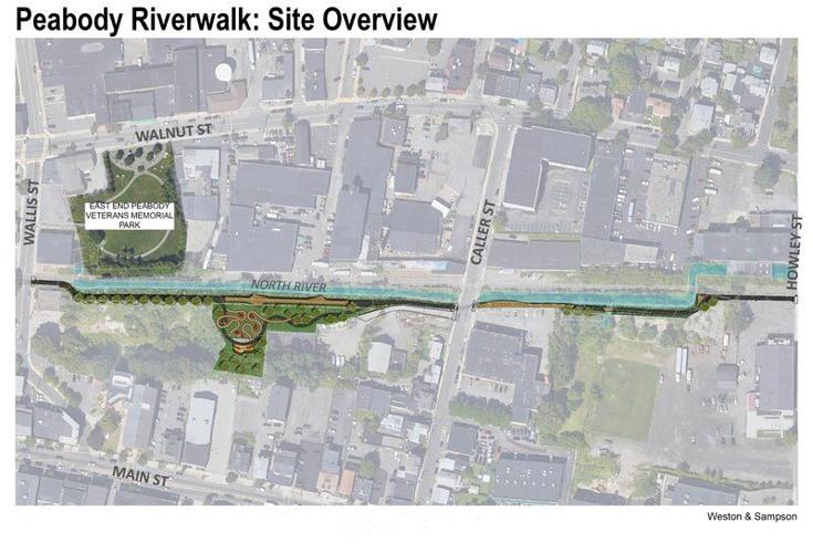
Note; Plans are in the works in Salem to extend the North River Canal Riverwalk West, to Peabody, where it will connect to the planned Peabody Riverwalk. See Map Below. Future plans would then connect the Peabody Riverwalk West, to the Independence Greenway, also in Peabody.
Marblehead Neck Loop:
While you are in the area, I would suggest an on-road bike tour of Marblehead Neck. Very scenic. From Pleasant Street & Marblehead Rail Trail; Swampscott Spur head left, on-road along Pleasant St. Take your second right onto Ocean Ave. After 0.7 miles you'll cross a causeway with a view to your left of scenic Lady's Cove/Marblehead Harbor and its 1,600 moored boats. This brings you to Marblehead Neck. Continue North, right along Ocean Ave. After 2.3 miles you'll pass a side trail that leads to Castle Rock before coming to the intersection with Harbor Ave at 2.4 miles. Continue right along Ocean Ave which becomes Follett St. This brings you to Chandler Hovey Park and its lighthouse at 2.8 miles. Great views of Salem Sound and the Massachusetts Bay. Return via Kimball St and Nahant St (one-way) back to Ocean Ave. Head right and continue straight onto Harbor Ave. This will bring you back to Ocean Ave and the causeway at 4.1 miles. Retrace your route back to Pleasant Street and turn left to rejoin the Marblehead Rail Trail; Swampscott Spur after a 5.1 mile Loop.
Old Railroad Equipment:
+
RR Rail Holders:
RR Rail Holders were used to store
extra railroad track alongside the train tracks. Usually made of iron or
concrete, the top is shaped like a small U to keep the tracks from
falling off. I assume these were used to keep the rails off the ground and
quickly available if needed. Couldn't find any information on them.
HH
CLICK HERE FOR MARBLEHEAD RAIL TRAIL MAP
CLICK HERE FOR SWAMPSCOTT RAIL TRAIL MAP
CLICK HERE FOR BORDERS TO BOSTON MAP
BEFORE YOU SET OUT BE SURE TO READ THE
WAIVER OF RESPONSIBILITY AND DISCLAIMER
BIKE IT OR HIKE IT