SARATOGA NATIONAL HISTORICAL PARK:
STILLWATER, NEW YORK
-BIKE IT OR HIKE IT-
Last Updated: August 22, 2025
Length: Tour Road Loop; 10.4 miles
Tour Road Loop with Stop Loops; 12.7 miles
Difficulty: Moderate. Paved road with BIKE LANE, however, some grades may be tough for kids on bikes.
Directions:
From the junction of Routes 4 & 32 in Stillwater, follow Route 32 north for 4.4 miles. The Park Entrance Road for the Battlefield will be on your right.
Saratoga National Historical Park; Here in the autumn of 1777 American forces met, defeated and forced a major British army to surrender. This crucial American victory renewed patriots’ hopes for independence, secured essential foreign recognition and support, and forever changed the face of the world. Bicycling is a scenic and popular way to tour the battlefield. Entrance fees are in effect during the fee season. [Entrance Fee Season: May 1 - October 31] There is a multi-use lane available for bicycling and pedestrian use on the 10-mile paved tour road. See; TOUR ROAD HOURS . For more information visit; NPS .
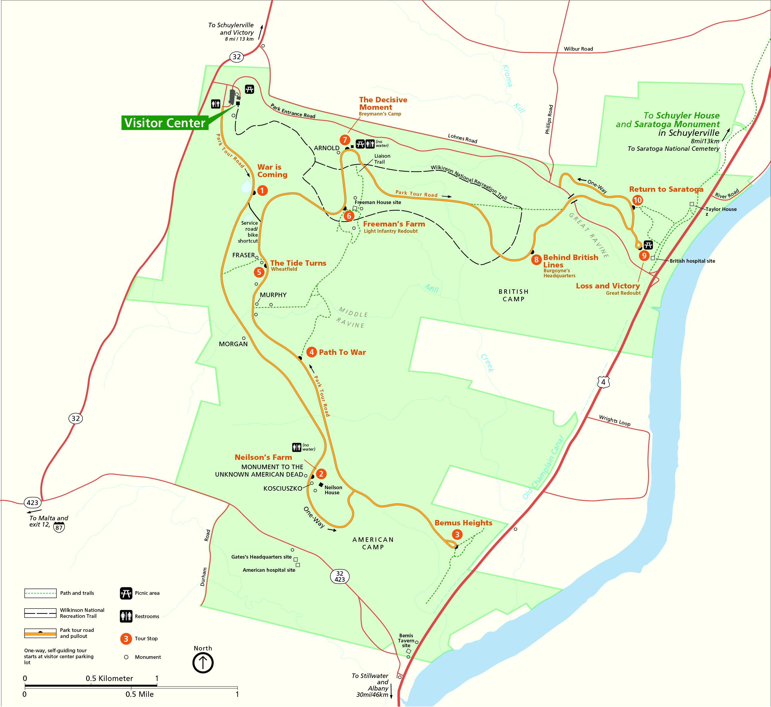
Starting from the Visitors Center (where you can get a Map); Exit the parking lot down to the Park Entrance Road and you'll find the start of the Tour Road. Brown sign reads "Battlefield Tour Road" This is a one-way paved road, with a BIKE LANE. The Tour Road travels throughout the battlefield and includes 10 Tour Stops along the way. Scattered among the stops are several Porto-Potty's and a few picnic tables. Most stops include a paved Loop Trail. There are some steep hills which would be tough for kids on bikes. Traveling South, Come to Stop 1 "War is coming", which has a Short Loop. Come to Stop 2 "Nelson's Farm" after 2.1 miles. Another Short Loop. The Tour Road then turns North, to an *Intersection at 2.7 miles.
Note; Right, East, the Tour Road leads to Stop 3 "Bemus Heights" at 3.2 miles. 0.6 mile Loop.
Returning back to the *Intersection, continue North. Come to Stop 4 "Path to War" at 4.5 miles. Come to Stop 5 "The Tide Turns" at 5.1 miles. Short Loop. The Tour Road turns East, bringing you to Stop 6 "Freeman's Farm" at 5.8 miles. 0.5 mile Loop. Head North, to Stop 7 "The Decisive Moment", Short Loop. Continue East, to Stop 8 "Behind British Lines" at 7.3 miles. Continue East, to another **Intersection and turn right to Stop 9 "Loss & Victory" at 8.1 miles. Great view of the Hudson River below. Return back to the **Intersection and continue North, to Stop 10 "Return to Saratoga".
Note; From Stop 10 a Trail leads East, down to the Champlain Canalway Trail-Saratoga NHP which follows along the Old Champlain Canal. See; Champlain Canalway Trail; Mechanicville-Schuylerville .
Travel West, back to the Park Entrance Road at 8.5 miles. Turn right, West, along the Park Entrance Road. For some unexplainable reason, there is no BIKE LANE along this road. It's almost 2 miles along an active road. Return back to the Visitor Center after a 10.4 mile Loops. However,, when you factor in all the stops and side trails we ended up with 12.7 miles.
HH
BEFORE YOU SET OUT BE SURE TO READ THE
WAIVER OF RESPONSIBILITY AND DISCLAIMER
BIKE IT OR HIKE IT