KINGSTON GREENLINE:
KINGSTON RAIL TRAIL:
KINGSTON MIDTOWN LINEAR TRAIL:
KINGSTON POINT RAIL TRAIL:
O&W CONNECTOR:
HUDSON RIVER BRICKYARD TRAIL:
KINGSTON, NEW YORK
-BIKE IT OR HIKE IT-
Last Updated: August 31, 2025
Length: Kingston Rail Trail; 1.8 miles
Kingston Midtown Linear Trail; 0.8 miles
Kingston Point Rail Trail; 2.8 miles
Waterfront Promenade; 0.6 miles
O&W Connector; 1.8 miles
Broadway 2 -Way CYCLE TRACK; 0.7 miles
Hudson River Brickyard Trail; 1.7 miles
River Pavilion Trail; 0.3 miles
Empire State Connector Trail; 0.25 miles
Steep Rocks Trail; 0.9 miles
Difficulty: Kingston Rail Trail; Moderate. Flat, narrow rail trail only partially developed.
Kingston Midtown Linear Trail; Easy. Flat, wide paved rail trail.
Kingston Point Rail Trail; Easy-Moderate. Paved & stone-dust rail trail. Long hill.
Waterfront Promenade; Easy. Brick & pavers trail.
O&W Connector; Easy. Flat, paved rail trail.
Hudson River Brickyard Trail; Easy. Wide paved trail w/some small hills.
River Pavilion Trail; Easy. Paved & crushed gravel trail w/same hill.
Empire State Connector Trail; Moderate. Paved trail w/steep hill.
Steep Rocks Trail; Moderate. Crushed gravel trail w/steep hill.
Directions:
To Start from Kingston Plaza in Kingston for the Kingston Midtown Linear Trail [Western End]; From the junction of I-587 and Albany Ave in Kingston follow Albany Ave west to Clinton Ave and turn right. Take your first right along Westbrook Ln. Cross the RR tracks and trailhead and park in Kingston Plaza.
To Start from the John Street parking lot in East Kingston for the Hudson River Brickyards Trail [Northern End]; From the intersection of Routes 9W & 32 in Kingston travel north on Route 32. Take your 2nd right on Main St, the your 2nd left to John St. Follow south to the parking lot.
The Kingston Greenline is a series of interconnected trails in the city of Kingston and will serve as a regional hub for the growing system of rail trails throughout Ulster County. For more information visit; KINGSTON GREENLINE .
Starting from Kingston Plaza: This is the start of the Kingston Midtown Linear Trail. It is also the start of the CATSKILL MOUNTAIN RR .
Heading West: From Kingston Plaza, the planned Catskill Mt Rail Trail will follow the old Ulster and Delaware RR West, alongside the Catskill Mt RR to *Washington Ave. The trail will then continue alongside the old Ulster and Delaware RR, as it turns Northwest and connects to the Ashokan Rail Trail in West Hurley. This trail continues West, alongside the Ashokan Reservoir, passing by Shokan before ending in Boiceville. For more information about the Catskill Mountain Rail Corridor, including the Ashokan Rail Trail.
Heading West: From Kingston Plaza, there is a Gap, as of 2024, between the Kingston Midtown Linear Trail and O&W Connector. You'll need to travel on-road along Schwenk Dr, West, to *Washington Ave. You'll continue along Schwenk Dr before picking up the O&W Connector on your right. The O&W Connector continues Southwest, where it connects to the Northern End of the Hurly Rail Trail in Hurley.
Heading East: From Kingston Plaza, the Kingston Midtown Linear Trail travels East, connecting to the Kingston Point Rail Trail & Waterfront Promenade.
From the Kingston Midtown Linear Trail you can connect to the Greenkill Ave Path & Greenville Ave 2-Way SEPARATED BIKE LANE which travels Southwest, through the city. A Gap, as of 2024, then requires an on-road route, to connect to the Wallkill Valley Rail Trail . This is also part of the Empire State Trail , a continuous 750-mile route spanning the state from New York City North, to Canada and Buffalo East, to Albany, creating the longest multi-use state trail in the nation.
From the Northern End of the Kingston Point Rail Trail, you can connect to the Hudson River Brickyards Trail, which travels North, along the Hudson River. For more information visit; HUDSON RIVER BRICKYARD TRAIL .
Kingston Greenline:
[Kingston Midtown Linear Trail West to O&W Connector]
Starting from Kingston Plaza [Western End]; This is where the CATSKILL MOUNTAIN RR begins. Check out the train engine and cars. As of 2024, a Gap exists to *Washington Ave. From Kingston Plaza, travel West, on-road, along Kingston Plaza & the RR tracks (low traffic) to the Plaza exit. Head left, out to Schwenk Dr, then right, West, on-road (sidewalk available). Come to *Washington Ave & Hurley Ave after 0.6 miles. You have 2 Options: You can start from the Washington Ave parking lot or the Hurley Ave entrance.
To start from the Washington Ave parking lot travel North and just before the RR tracks on your left, is the Washington Ave parking lot, after 0.7 miles.
To start from the **Hurley Ave entrance; Travel West, along Hurley Ave, where you'll pick up a BIKE LANE. After 0.8 miles come to the O&W parking lot on your right. Travel North, through the parking lot, to connect to the paved Spur Trail, which will bring you to the paved O&W Connector after only 0.1 miles.
[O&W Connector]
Starting from the Washington Ave parking lot [Eastern End]; Map Board & picnic table. The wide, paved O&W Connector travels West, along the old rail bed and quickly brings you to the a Spur Trail on your left.
Note; This paved Spur Trail takes you South, to the O&W parking lot, which you travel through to **Hurley Ave after only 0.1 miles.
The O&W Connector follows an open power line corridor, along a causeway through a marshy area. Travel through a tunnel, underneath I-87 and across Hurley Ave Ext at 0.5 miles. Pass by a wooden replica RR Mileage Marker E26/K1 (Ellenville 26 miles/Kingston 1 mile) at 0.8 miles. These old RR Mileage Markers were located every mile along the railroad. Pass by an electrical sub-station at 1.1 miles as the trail turns South. You'll briefly catch a glimpse of Esopus Creek, below on your right, before passing by a marsh and an old farmers tunnel (allowed farm animals to pass underneath Route 209) on your right and connecting to the paved Hurly Rail Trail after 1.8 miles. Map Board.
Note; Right, North, will take you 0.3 miles to the Route 209 parking lot and Northern End of the Hurley Rail Trail.
[Kingston Midtown Linear Trail]
Starting from Kingston Plaza [Western End]; This is where the CATSKILL MOUNTAIN RR begins. Check out the train engine and cars. Map Board & informational signs all along the route.
Note; Heading West; future plans call for building a trail alongside the tracks the Catskill Mt RR uses to *Washington Ave. Here you'll be able to connect to the O&W Connector (Upgrade & paving approved Feb. 2023) which connects West, to the Hurly Rail Trail. The future Catskill Mt Rail Trail will continue Northwest, connecting to the Ashokan Rail Trail.
Heading East; The wide, paved Kingston Midtown Linear Trail travels past the Catskill Mt RR train before heading through a tunnel underneath I-587. At 0.3 miles, just before another tunnel look left to spot an iron pole that looks like half a T. I believe this used to be an old RR Warning Pole (It would have had chains hanging off). + See; RR Brakeman's Warning Pole Below. Travel under Albany Ave and along a sunken corridor. Travel under Elmendorf St, before emerging at Downs St. The trail continues East, crossing Oneil St and Cornell St, before traveling around the Cornell Street parking lot (constructed of permeable asphalt) to Thomas St, where it turns South, to ***Fashion Lane at 0.8 miles.
Note; To connect to the Greenkill Ave Path & Greenville Ave 2-Way SEPARATED BIKE LANE, which travels Southwest, through the city and will eventually connect to the Wallkill Valley Rail Trail . [Re-zeroing Mileage] Head left, on-road, along Fashion Ln to Railroad Ave and travel right, Southwest, on-road, crossing a bridge over Broadway where you'll pick up the paved Greenkill Ave Path on your left at 0.2 miles. RR tracks on your left where I watched a super long train travel by. Some interesting converted old brick mill buildings along here. Pass by Barmann Park, before crossing S Clinton Ave, where you'll pick up the Greenville Ave 2-Way SEPARATED BIKE LANE at 0.6 miles as it travels down a slight hill. Come to Wall St and bare left to Boulevard Ct at 0.8 miles, where you'll need to continue South, on-road (wide shoulder). After 1.8 miles you'll pick up the Wallkill Valley Rail Trail on your right. This is also part of the Empire State Trail .
From ***Fashion Lane continue along the paved Kingston Midtown Linear Trail to the Broadway 2 -Way CYCLE TRACK.
Note; Heading right, West, the Broadway 2 -Way CYCLE TRACK travels 0.5 miles to the Albany Ave/Col Chandler Dr rotary .
Head left, East, along the Broadway 2 -Way CYCLE TRACK. Come to Prince & Grand Streets and turn left on Prince St (short BIKE LANE). Take your 2nd right on Hasbrouck Ave (BIKE SHARROWS). Right, South, on Foxhall Ave, first left, East, on Jansen Ave (where the old rail bed was located) and you'll come to E Chester Street and the start of the Kingston Point Rail Trail after 1.6 miles.
[Kingston Point Rail Trail]
Continuing from E Chester Street [Western End]; [Continuing Mileage] Map Board, picnic tables here. The paved Kingston Point Rail Trail travels East, along the old rail bed along a sunken corridor and is mostly all downhill. You travel through a long tunnel underneath Delaware Ave before crossing Route 9W via an old RR bridge. Crosswalk over Delaware Ave where the trail travels through a residential corridor with residential road crossings. Cross light over Delaware Ave to a small pocket park with a Map Board and benches as the trail heads South. Pass by Rondout Community Garden before crossing an old RR bridge at 2.8 miles. Here the trail follows a berm.
Note; The old rail bed continues straight, before veering left, East, down to the TROLLEY MUSEUM OF NY . Phase 2 calls for continuing the trail along this route.
A ramp leads down to Route 9W and another Map Board. Detour left, South, along a narrow sidewalk. This brings you down to Rondout Landing and the Kingston Waterfront. Head left, Northeast, along the sidewalk and come to where the RR tracks cross Rondout Landing at 3.1 miles. On your left is the TROLLEY MUSEUM OF NY .
Note; From here you can access the Waterfront Promenade. Turn right across Rondout Landing and the old RR tracks. Continue straight along the brick lined trail which quickly brings you to Rondout Creek. Boat docks and informational signs along the bricks and pavers trail that travels Southwest. You'll quickly pass by the HUDSON RIVER MARITIME MUSEUM (Rondout Creek empties into the Hudson River) and some old ships before traveling underneath the Route 9W Bridge and past HUDSON RIVER CRUISES . Pass by T. R. Gallo West Strand Park (picnic tables) and a promenade on your right. Plenty of eateries. You then travel underneath the Wurts Street Bridge and come to Hideaway Marina where the trail turns out to Abeel St after 0.6 miles.
Continuing Northeast, along the Kingston Point Rail Trail, you'll travel on-road along Rondout Landing (BIKE SHARROWS). Pass the old brick 1827 Cornell Steamboat Co building. Hold your nose, waste treatment plant along your left. The RR tracks cross the road again and follow alongside the road. At 3.4 miles, just before E Strand St, cross the tracks to a crushed gravel trail that parallels the tracks into the open woods. Pass by an old RR Siding and RR Switch. + See; RR Switch Below. The trail then travels along a causeway with a marsh on your left and the Hudson River to your right. Spot the Rondout Lighthouse where Rondout Creek empties into the Hudson River. Very scenic view. Across the river is Rhinecliff. Trail turns North. Cross a bridge, off the old rail bed which has been removed here and enter Kingston Point Rotary Park (picnic tables, pavilions, gazebo). Exit the Park to Delaware Ave and the Kingston Point Rotary Park parking lot after 4.4 miles.
Note; You can Loop back to the Kingston Waterfront on-road from here. Head left, East, past the Kingston Point Rotary Park parking lot. Dog Park, sports fields, BMX, restrooms here. Take a quick detour right to check out Kingston Point Beach. Pavilion, Porto-Potty. Great views of the Hudson River and Kingston-Rhinecliff Bridge in the distance. To your left spot the old Hudson Brickworks factory. Continue along Delaware Ave (BIKE SHARROWS) to North St. Head left, South, on North St (BIKE SHARROWS) up a slight hill. Keep right to E Strand St. Return to Rondout Landing and the Kingston Point Rail Trail after 3.8 miles.
[Hudson River Brickyard Trail]
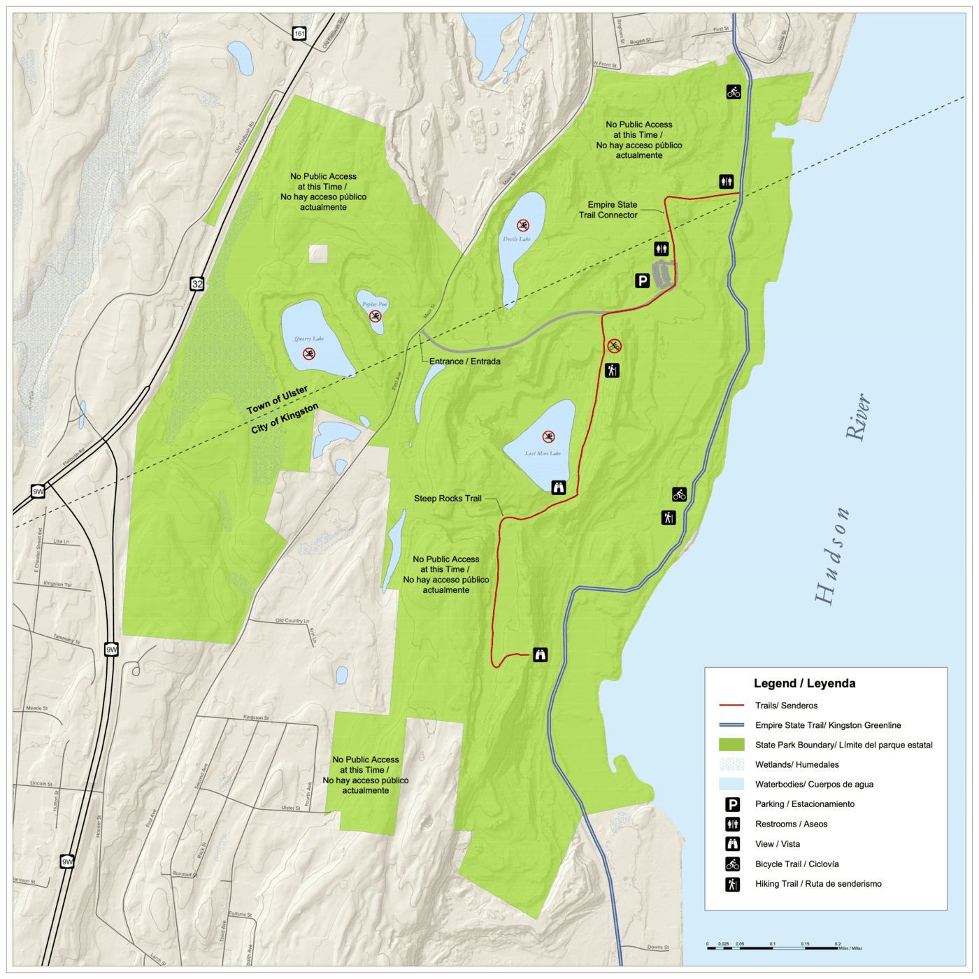
From Delaware Ave/Kingston Point Rotary Park parking lot [Southern End]; [Re-zeroing Mileage] Head left, West, on-road, along Delaware Ave (BIKE SHARROWS). Dog Park, sports fields, BMX, restrooms on your left. Pass by Kingston Point Beach, on your right. Pavilion, Porto-Potty. Great views of the Hudson River and Kingston-Rhinecliff Bridge in the distance. Continue, on-road, along Delaware Ave to North St and head right, on-road. After 0.4 miles you'll pass a gate house, where the stone-dust Hudson River Brickyard Trail begins. Map Board. Travel past the Hutton Brickyards complex. Check out the fence posts filled with bricks from the old brickyard. The old brickyard, which you can still spot some remnants on your right, is now the HUTTON BRICKYARD resort. Come to the official start of the Hudson River Brickyard Trail after 0.7 miles. Here the wide, paved trail travels through open forest and includes some small hills. Some brief views of the Hudson River. Come to an intersection at 1.7 miles.
Note; Right, this crushed gravel River Pavilion Trail takes you down to SOJOURNER TRUTH STATE PARK . Here you'll find a pavilion, picnic tables, benches, informational signs, Porto-Potty and a promenade overlooking the Hudson River. The now paved trail, takes you up a slight hill, passing by another overlook, back to the Hudson River Brickyard Trail after 0.3 miles.
Continuing straight, you'll come to another intersection at 1.9 miles.
Note; On your right is where the River Pavilion Trail re-joins the trail. On your left, the wide, paved Empire State Connector Trail takes you West, up a hill, past more Porto-Potty's, then Southwest, to the Old Post Road parking lot after 0.25 miles. Here you'll find a Map Board, Porto-Potty and historic industrial ruins and remnants from brick making and quarrying. The crushed gravel Steep Rocks Trail (No bikes allowed) travels South, down hill, past Lost Mine Lake, to an overlook of the Hudson River after 0.9 miles. I haven't checked out this trail.
Continuing straight, North, you'll pass by an old brick building, before coming to the John Street parking lot after 2.1 miles. Map Board & BIKE STATION.
Note; To continue along the 7.9 mile on-road portion of the Empire State Trail continue straight, North, uphill along John St (residential). See; Albany-Hudson Electric Trail for information. Not recommended for novice bikers.
Old Railroad Equipment:
+ RR
Brakeman's Warning Pole:
Prior to 1888 when Westinghouse developed a reliable air
brake, stopping a train or a rolling car was very primitive. Iron wheels,
located atop cars, were connected to a manual braking system by a long metal
rod. The brakemen, usually two to a train, would ride on top of the car. On a Whistle
signal from the engineer, the brakemen, one at the front of the train and one at
the rear of the train, would begin turning the iron wheels to engage the brakes.
The Brakeman Warning Pole consists of a rail in the shape of an upside
down L, hanging over the center of the trail. The chains hanging down
over the rail line would hit the railroad brakeman, who was on top of the train
and warn him of an upcoming bridge or tunnel.
+ RR Switch:
A RR Switch is a mechanical
installation enabling trains to be guided from one track to another, such as at
a junction or where a spur or siding branches off.
HH
CLICK HERE FOR KINGSTON GREENLINE MAP
CLICK HERE FOR HUDSON RIVER BRICKYARD TRAIL MAP
CLICK HERE FOR SOJOURNER TRUTH STATE PARK MAP
CLICK HERE FOR EMPIRE STATE TRAIL MAP
BEFORE YOU SET OUT BE SURE TO READ THE
WAIVER OF RESPONSIBILITY AND DISCLAIMER
BIKE IT OR HIKE IT