HERITAGE-WAY BIKE PATH:
WETHERSFIELD, CONNECTICUT
-BIKE IT OR HIKE IT-
Last Updated: July 02, 2025
Length: Heritage-Way Bike Path; 16.5 mile Loop
Difficulty: Moderate. A lot of on-road sections, also some hilly sections. It can be difficult at times to follow the route without missing a turnoff.
Directions:
To start from the 1860 Reservoir [Southwestern End]; From I-91, take exit 25 to Route 3 (Maple St). Look for Hang Dog Lane on the right. Take it to Highland St and turn right. Look for a narrow dirt road on your left, with a yellow gate, this is also a boat launch site. Green "Bike Sign" at the entrance.
To start from Mill Woods Park [Southwestern Section]; From I-91, take exit 25 to Route 3 (Maple St). Take a right onto Prospect St. The park entrance will be on your left.
Wethersfield's Heritage-Way Bike Path is a multi-use path that connects many of the Town's existing recreation facilities via a partial Loop. The Heritage-Way occupies both off-road paths on town-owned land as well as existing roadways that are enhanced with safety signs. Note; A good portion of this route travels on-road. Not recommended for kids on bikes.
Starting from the 1860 Reservoir parking lot/Highland Street [Southern End]; There is a signboard located next to the boat launch and parking area.
Note; Take a quick side trip by heading past the two large cement barriers along a dirt trail to a small bridge. From here you'll have a nice view of the Reservoir.
Travel back out to Highland St. Hang a left, North and travel on-road (wide shoulder) along the Heritage-Way Bike Path. There is also a narrow sidewalk available. There are green "bike route" signs posted all along the route. Highland St bears right, East. You pass by Highcrest fields after 0.7 miles and start a long downhill decent. Take a left, North, on-road along Griswold Rd (No shoulder marked/sidewalk available) and at 1.9 miles take a right, East, onto a stone-dust path into Mill Woods Park. You'll pass by the ball fields and enter a parking lot. Head left through the lot and follow the road out towards the tennis courts. Here, you'll find another signboard. Follow the road left, North, out the exit to Prospect St. A cross light is too your left that will take you over Prospect St. Continue North, on-road up Wolcott Hill Rd (No marked shoulder/sidewalk available), keeping a sharp eye out to your left, West, for Brimfield Rd (residential). If you come to a deli and grocery store, you missed it (good chance to grab some refreshments however). Along the right side of Brimfield Rd will be a stone-dust trail referred to as Folly Brook Blvd at 2.9 miles. Follow this trail as it travels North, through a residential corridor. Cross Wells Rd at 3.4 miles. Continue North, on-road along Folly Brook Blvd to the Wintergreen Woods parking lot at 3.6 miles. Sign board. The stone-dust Wintergreen Woods Trail is a bit wider along this section as it travels between woods and Wethersfield High School. Pass by access to *Church Street at 4 miles. After crossing over Nott St at 4.3 miles, Continue on-road, along Folly Brook Blvd (residential).. Take your first right, East, on-road along Greenfield St and pass by the Pitkin Community Center. This brings you out to Park St, which is divided by a median. Head left, North and take a right, East, when you come to Cumberland Ave. This is a very pleasant neighborhood with a tree lined median. You'll need a sharp eye to spot a narrow, stone-dust path on your right, South, just before the end of this road. Look for the green "Bike" sign. This "school path" then crosses over Oxford St and continues as a narrow, paved path alongside Charles Wright elementary school and out to Nott St at 5.6 miles. Hang a left, East and travel on-road (residential) and cross over Silas Deane Highway via the cross-light. Continue along Nott St (narrow shoulder), traveling over the railroad tracks and you'll pass by Standish Park (playground). This brings you to Hartford Ave. Take the crosswalk over Hartford Ave, turn left and use another crosswalk over State St. Follow Hartford Ave North, past the Soloman Wells House, then turn right into the Cove Park parking lot at 6.3 miles. A stone-dust trail heads East, through Cove Park, bringing you to a nice overlook of Wethersfield Cove. Benches and picnic tables are located here. The trail travels alongside the cove and brings you to Hanmer Rd.
Note; Take a quick detour by heading left, North, which will bring you to Wethersfield Cove Park. A parking lot is located here.
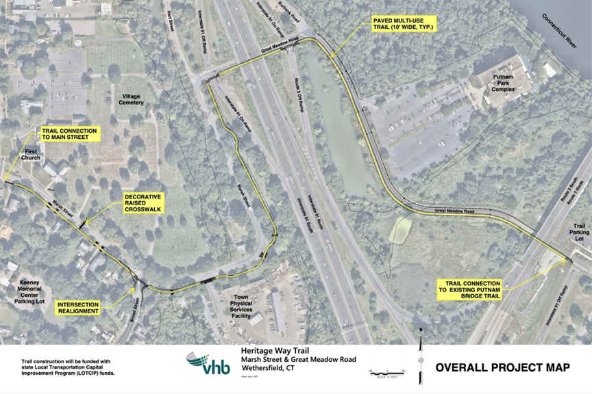
Turn right and follow Hanmer Rd up to Main St. Turn right, South, on-road along the broad, tree lined Main St, passing by old historic homes dating back to the 1600's to 1800's. At 7.2 miles you need to keep a sharp eye to your left for **Hart Street. Travel East, on-road along this narrow residential street. Come to the **Intersection of Marsh Street & Great Meadow Road.
Future construction will create a paved trail both South, alongside **Marsh Street to ***Broad Street and West, to ****Main Street. Another paved trail will travel East, alongside **Great Meadow Road, then South, to the Great Meadow Road parking lot, where you can access the Putnam Bridge Bike Path . See; Map Below. Future plans will next extend the trail North, along ****Main Street to Cove Park.
Turn left along Great Meadows Rd following a SEPARATED BIKE LANE and travel underneath I-91. Turn right, South, down Great Meadows Rd and you'll then travel underneath Route 3 and come to the Great Meadows Road parking lot at 8 miles.
Note; From the Great Meadows Road parking lot a paved trail crosses Great Meadows Rd and travels up to the Putnam Bridge Bike Path , which travels Northeast, across the Connecticut River, to the Naubuc Ave parking lot in Glastonbury. Here, heading South, on-road, will bring you to the Riverfront Park Trail in Glastonbury, which is part of the Glastonbury Trails network. Also, a Spur Trail off the Putnam Bridge Bike Path in Glastonbury leads down to the South Meadows River Trail , which travels North, along the Connecticut River to E Hartford. See; Map Below.

Continuing South, on-road, along Great Meadows Rd, you'll come to a large yellow gate. Road closed to traffic beyond here.
Note; Be Aware; This last section is very isolated.
The road deteriorates and the pavement brakes up as you pass through large fields heading East. You'll come to a dirt road on your right, labeled 2nd Lane on the Map, after 8.5 miles. Travel right, South, along 2nd Lane. Follow this rough, dirt road and you'll soon come alongside the Connecticut River. The road splits at Elm Street & Elm Street Extension.
Note; You may continue South, along the dirt Elm Street Extension, as it follows the Connecticut River past farm fields.
Head right, West, along dirt Elm Street away from the river and you'll travel underneath I-91 to Elm St and Great Plain Ln at 9.7 miles. Head right, Northwest, on-road along Elm St (low traffic), passing scenic horse farms and you'll come to Route 3. There is a cross-light, however, this is a very busy and dangerous road so USE CAUTION. Continue Northwest, on-road along Elm St (low traffic), which will bring you out to Broad St (separated by the Town Green). Head right, North, on-road along ***Broad Street (shoulder) and follow to ***Marsh Street. See; Map Above for future paved trail along **Marsh Street. Head left, West, on-road along Marsh St (No shoulder/sidewalk available) to ****Main Street at 11.2 miles. Continue across Main St, on-road along Church St (low traffic) to the stone-dust Wintergreen Woods Trail at the end of *Church Street after 12.5 miles.
Note; Retrace route back to the 1860 Reservoir parking lot for a 16.5 mile Loop.
HH
CLICK HERE FOR HERITAGE WAY BIKE MAP
CLICK HERE FOR HERITAGE WAY BIKE ROUTE MAP
BEFORE YOU SET OUT BE SURE TO READ THE
WAIVER OF RESPONSIBILITY AND DISCLAIMER
BIKE IT OR HIKE IT