GRAND JUNCTION TRAIL:
AMES STREET BIKE LANE & KITTIE KNOX BIKE PATH
CAMBRIDGE, MASSACHUSETTS
-BIKE IT OR HIKE IT-
Last Updated: November 16, 2024
Length: Grand Junction Trail; 1.3 miles.
Ames Street Bike Lane & Kittie Know Bike Path; 0.6 miles
Difficulty: Easy. Flat paved trail. Also includes Bike Lanes.
Directions:
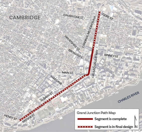
The Grand Junction Trail is a planned multi-use path, traveling along the former Grand Junction RR corridor, from the Boston University Bridge, next to the Charles River Bikeway , Northeast through Cambridge, then North to Somerville, where it will connect to the Mass Central Rail Trail; Boston-Cambridge-Belmont (Somerville Community Path). Currently only a short section is complete, however, I've included the BIKE LANES along Vassar Street, as they currently follow the same route. The Grand Junction was one of the first North-South rail links in the Boston metropolitan area. Opened in 1855 by the Grand Junction & Depot Company, the line followed a serpentine alignment weaving through the newly industrialized areas of Cambridgeport, East Cambridge, Charlestown, Everett and Chelsea and ending at the piers of East Boston. Presently, two to four trains a day run on the Grand Junction through Cambridge, as this corridor remains the only North-South rail connection East of Framingham and Worcester. The Ames Street 2-WAY SEPARATED BIKE LANE also starts from the Charles River Bikeway and connects North to the Kittie Knox Bike Path. Both of these trails are connected together by other BIKE LANES. See; Kittie Knox . For more information visit; GRAND JUNCTION TRAIL .
Grand Junction Trail:
Starting from the Charles River Bikeway at Memorial Drive & Vassar Street [Southwestern End]; Across Memorial Drive is the Charles River Bikeway . The Vassar Street BIKE LANE travels Northeast, along Vassar St, through MIT. You then pick up a SEPARATED BIKE PATH at Amherst Alley, before passing by the sports fields of Briggs Field. Cross Mass Ave at 0.8 miles.
Note; The Mass Ave BIKE LANE travels Northwest through Cambridge and Southeast, across the Charles River, through Boston along Main St.
Just before Main St, look right to spot the whimsical Stata Center, designed by Architect Frank Gehry. Come to Main St at 1.1 miles.
Note; The Main Street BIKE LANE travels West to Lafayette Square and Main St, where you can connect to the Mass Ave BIKE LANE and East to Memorial Dr and the Charles River Bikeway .
Cross Main St to Galileo Galilei Way, where the paved Grand Junction Trail travels North, through Grand Junction Park, between Galileo Galilei Way and the RR tracks. Nice sitting area. Come to Broadway at 1.3 miles.
Note; The Broadway BIKE LANE travels Northwest to Columbus St and Southeast to the Main Street BIKE LANE and East to Memorial Dr and the Charles River Bikeway .
Cross Broadway, where the trail continues through Binney Street Park. Dog Park. A BIKE LANE also leads to Binney St.
Note; Future construction will continue the trail North from Binney St to Cambridge St. See; Map Below.
Note; The Binney Street BIKE LANE travels East, along Binney St to Edwin Land Blvd. Triangle Park on your right. Cross over and turn left to Charles Park on your right. A brick lined trail will return you to the Charles River Bikeway after 0.7 miles.
Ames Street BIKE LANE & Kittie Knox Bike Path:
Starting from the Charles River Bikeway at Memorial Drive & Ames Street [Southern End]; From the Charles River Bikeway the Ames Street 2-WAY SEPARATED BIKE LANE travels North along Ames St. Cross Main St at 0.3 miles.
Note; The Main Street BIKE LANE travels West to Lafayette Square and Main St, where you can connect to the Mass Ave BIKE LANE and East to Memorial Dr and the Charles River Bikeway .
Cross Broadway to Kendall Square at 0.4 miles.
Note; The Broadway BIKE LANE travels Northwest to Columbus St and Southeast to the Main Street BIKE LANE and East to Memorial Dr and the Charles River Bikeway .
Here you'll pick up the paved Kittie Knox Bike Path as it travels North along a shaded corridor. The Loughrey Walkway parallels the trail. You come to Binney St after 0.6 miles.
Note; The Binney Street BIKE LANE travels East, along Binney St to Edwin Land Blvd. Triangle Park on your right. Cross over and turn left to Charles Park on your right. A brick lined trail will return you to the Charles River Bikeway after 0.6 miles.
HH
BEFORE YOU SET OUT BE SURE TO READ THE
WAIVER OF RESPONSIBILITY AND DISCLAIMER
BIKE IT OR HIKE IT