TWO RIVERS GREENWAY:
CHENANGO RIVER TRAIL:
OTSININGO PARK TRAILS:
ROUTE 434 GREENWAY:
VESTAL RAIL TRAIL:
CHUGNUT TRAIL:
BINGHAMTON-ENDICOTT-VESTAL, NEW YORK
-BIKE IT OR HIKE IT-
Last Updated: October 11, 2025
Length: Chenango River Trail; 2.6 miles
Otsiningo Park Loop Trail; 5 miles
Old Front Street Spur Trail; 0.3 miles
Route 11 Greenway; 1.2 miles
Route 434 Greenway; 2.8 miles
Vestal Rail Trail; 3.5 miles
Chugnut Trail; 1.2 miles
Difficulty: Chenango River Trail; Easy. Flat, paved trail.
Otsiningo Park Trails; Easy. Flat paved trails.
Route 11 Greenway; Easy. Flat paved trail.
Route 434 Greenway; Easy. Flat paved trail.
Vestal Rail Trail; Easy. Flat paved rail trail.
Chugnut Trail; Easy. Flat, paved trail.
Directions:
To start from Conklin & Pennsylvania Aves [Southern End-Chenango River Trail & Route 434 Greenway]; From I-81/86 & Route 17 take exit 4S to Route 363 south. Exit to Route 434 south over the Susquehanna River. Take your first exit to Conklin Ave and turn left. Parking spots are located on the right, just before Pennsylvania Ave and the pedestrian bridge over the Susquehanna River (start of trail).
To start from Cheri Lindsey Park [Northern End-Chenango River Trail]; From I-81/86 & Route 17 take exit 4N to Route 363 north and immediately take your first exit to Bevier St (Route 145). Head left to Chenango St and turn left. Just after you pass below the interstate turn right on Truesdell St to the park. The trail runs along the river.
To start from Otsiningo Park [Southern End-Otsiningo Park Trails]; From I-81 take exit 5 to Front St (Route 11) and travel south (left). Turn left on Bevier St and the park entrance is on your left. The trail starts off Bevier St but parking is in the park
To start from Howell Drive parking lot [Northern End-Otsiningo Park Trails]; From I-81 take exit 5 to Front St (Route 11) and travel north (right). After passing under the interstate take your first right on Howell Dr and follow to the parking lot. Trail starts at end of road.
To start from the African Rd parking lot [Eastern End-Vestal Rail Trail]; From I-86 take exit 67S to Route 26 south to Route 434 (Vestal Pkwy). Turn right (east) along Route 434 and take your first left on African Rd. The parking lot is next to the Home Goods plaza on your left.
To start from the Stage Rd parking lot [Western End-Vestal Rail Trail]; From I-86 take exit 67S to Route 26 south to Route 434 (Vestal Pkwy). Turn left (west) along Route 434 and take your first right on N Main St, then a right on Stage Rd. Parking lot is on your right.
To start from the Riverview Drive parking lot [Eastern End-Chugnut Trail]; From the junction of Routes 17 & 26 in Vestal follow Route 26 north over the Susquehanna River. Take your first exit down to Route 17C (E Main St) and head right. Take an immediate right on Roosevelt Ave and follow to Riverview Dr. Turn right and the parking lot will be on your left.
Two Rivers Greenway is a region al network of trails surrounding the greater Binghamton area. These trails include the Chenango River Trail, also known as the Binghamton River Trail that starts at Southside Park in Binghamton, crosses a pedestrian bridge over the Susquehanna River and travels North, alongside the East Bank of the Chenango River to Cheri Lindsey Park. A short on-road section takes you across the Chenango River to Otsiningo Park where you may continue North, through the park. In Otsiningo Park, bike and pedestrian paths are combined with picnic areas and athletic fields on a unique area of wooded riverbank. If you check out the Park Map you'll see that the trails are color coded and represent different sections in the park. I created a Loop Route through the park. The Otsiningo Park Loop Trail follows trails North, alongside the West Bank of the Chenango River to the Howell Drive parking lot. It then Loops South South , back through the park utilizing inland trails. For more information visit; OTSININGO PARK . From Otsiningo Park you can also access the Route 11 Greenway, which travels North-South, alongside Route 11. The Route 434 Greenway connects the Southern End of the Chenango River Trail West, parallel to Route 434 to Binghamton University. Further West, in Vestal, the Vestal Rail Trail runs West, along the former rail bed of the Delaware, Lackawanna & Western Railroad. Built in the 1880's this line ran from Binghamton to Buffalo. Also, from the Center of the Vestal Rail Trail, you can connect to the Chugnut Trail by heading North, across the Susquehanna River, which utilizes part of the Susquehanna River Levee system in the town of Endicott. For more information visit; TWO RIVERS GREENWAY .
Chenango River Trail:
Starting from Conklin & Pennsylvania Aves in Binghamton; The Southern End of the Chenango River Trail starts at Conklin & Pennsylvania Aves, next to Southside Park and travels North, over the Susquehanna River via an iron pedestrian bridge (former South Washington Street Parabolic Bridge; 1886 Berlin Iron Bridge Company, East Berlin, CT ).
Note; This is also the start of the Eastern End of the Route 434 Greenway. See Below.
A BIKE LANE travels down the center of the bridge. Three separate paths lead from the bridge when you reach the opposite side.
Note; Right the BIKE LANE takes you across N Shore Dr to a Map Board for on-road biking routes in the area.
Head left down to Confluence Park where you'll find some history on the Chenango Canal (this was the Southern End of the 97 mile Canal). Follow the paved trail right through the park to a tunnel underneath N Shore Dr. This will bring you to the Chenango River Promenade alongside the Chenango River. The trail travels North, above & along the Eastern Side of the river. At 0.3 miles the trail splits. You may take either trail.
Note; Left brings you down alongside the river for a bit before heading back up at a 0.5 miles by some granite terraces. If you continue straight underneath Court St the trail simply dead ends at 0.6 miles.
Heading right takes you above the river with access to downtown Binghamton. Nice period street lamps and benches along the trail. Pass by the ramp to the lower trail at 0.5 miles before coming to Court St. Two Rivers Greenway Map Board. Cross-light over Court St to the MLK Park & Promenade with tree lined benches overlooking the river. When you reach E Clinton St after 0.9 miles the trail detours right to Water St. Continue North, along Water St via a paved trail. You pass underneath two active RR bridges and by some beautiful old brick buildings before you come alongside the river again at 1.2 miles. Pass by some floodplains on your left and commercial/industrial along your right. You come to Cheri Lindsey Park parking lot at 1.8 miles. Binghamton Skatepark, North Side Pool, playground & sports fields. Two Rivers Greenway Map Board. The paved trail continues East alongside Truesdell St, turning into a double-sided sidewalk out to Chenango St at 2.1 miles. Continue left, North, on-road along Chenango St (wide shoulder/sidewalk available) to Bevier St. Head left, West, utilizing the Bevier Street BIKE LANE and cross over the Chenango River. This will bring you to the Otsiningo Park Trails trailhead and entrance to Otsiningo Park on your right after 2.6 miles.
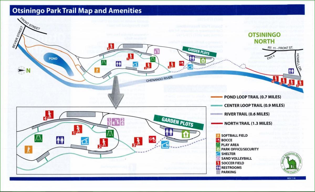
Otsiningo Park Trails:
Starting from Bevier Street & the Otsiningo Park entrance [Southern End]; The paved Otsiningo Park Trails travels North, through the park.
Note; Continuing straight, West, along the Bevier Street BIKE LANE takes you out to Front St (Route 11) and the wide, paved Route 11 Greenway. I haven't checked out this trail. T
Heading South; The trail travels along the Eastern Side of Route 11, ending after 0.7 miles, just shy of Prospect St.
Heading North; Cross Route 11, where the trail travels along the Western Side of Route 11, Cross over I-81 and come to a roundabout after 0.5 miles. A BIKE LANE continues North, along Route 11 and will bring you to the CUTLER BOTANIC GARDEN after 0.7 miles.
Enter Otsiningo Park along the Pond Loop Trail and pass by a Spur Trail on your right.
Note; This Spur Trail takes you underneath and up to Bevier Street & Route 11.
Northern Route:
Heading North; The Otsiningo Park Loop Trail splits ahead, so bear right alongside the Chenango River, as you travel through open mowed grass fields shaded by trees. Picnic tables are located throughout the park. Head past a small pond on your left before coming to an intersection at 0.4 miles for the Center Loop Trail. Keep right past a Map Board. Parking lot located to the left. Come to an intersection after 0.7 miles for the River Trail and continue straight. Head straight past another intersection that bears left up to the park offices, restrooms and a pavilion. The trail now heads away from the main park and through some wooded flood plains. More isolated. When the trail splits you can head either way as it rejoins quickly. Here the trail utilizes an old road (New North Trail). Travel underneath I-88 at 1.7 miles. Porto-Potty located here. This section of the park is narrow as you have the river along your right and I-81 up to your left. Pass by some soccer fields before coming to the Howell Drive parking lot after 2.5 miles. Restrooms and a Map Board are located here.
Southern Route:
Starting from the Howell Drive parking lot [Return Route]; Heading South; Follow the Otsiningo Park Loop Trail South, along the closed road past the soccer fields and into the wooded flood plains along New North Trail. This section of the park is narrow as you have the river along your left and I-81 up to your right. Travel underneath I-88 where you leave the interstate behind. When the trail splits you can head either way as it rejoins quickly. Your now following the River Trail. Continue straight past a spur trail on the right that leads up to the park offices, restrooms and a pavilion at 1.6 miles before coming to a Y-intersection. Bear right along the Center Loop Trail. Cross the park road and into the center of the park. Parking lots and picnic tables are located along this section. You'll pass by a playground before crossing back over the park road and coming to a T-intersection. Head right along the Pond Loop Trail around the small pond. At your next intersection head right up to Bevier Street after 2.5 miles. 5 mile Loop.
Route 434 Greenway:
Starting from Conklin & Pennsylvania Aves in Binghamton [Eastern End]; I have not checked this trail out yet.
Note; This is also the start of the Southern End of the Chenango River Trail. See Above.
The Route 434 Greenway follows a double-wide sidewalk West, along the South Side of Pennsylvania Ave. Pennsylvania Ave quickly turns South, as a bridge over Route 434. Across Route 434 the trail turns left off Pennsylvania Ave and becomes paved as it travels back underneath Pennsylvania Ave. It then heads through a tunnel under an on-ramp to an intersection at 0.3 miles.
Note; Straight, the trail leads out to Pennsylvania Ave and ends.
The Route 434 Greenway continues right, West, alongside Route 434. Come to an intersection at 0.9 miles.
Note; Left, South, takes you to the MacArthur Park parking lot.
The trail briefly turns away from the highway. Come to another intersection at 1.2 miles.
Note; Left takes you up to Vestal Ave.
Come to Murray Hill Rd after 2.8 miles and the end of the trail. From here you can access Binghamton University.
Vestal Rail Trail:
Starting from the African Rd parking lot [Eastern End]; A restroom and gazebo are located here.
Note; The Vestal Rail Trail is being expanded 0.6 miles East, to Sycamore Rd. A new parking lot will be constructed at the corner of African & Vestal Rd. Also, the trail will connect to Harold Moore Park, North across Vestal Rd. Should be complete by November 2025.
The wide, paved Vestal Rail Trail travels West, behind a commercial corridor on your left and a dike to your right. Willow Run is the stream on your left. Mile Markers are painted every 0.25 miles on the pavement. You pass by a small playground with picnic tables and a pavilion on your right at 0.4 miles. The trail then parallels Route 434 for a bit and so can be a bit loud. At 0.9 miles you'll come to a sign board on your right.
Note; A 0.6 mile nature trail Loops out around a marsh and then back to this trail further ahead. Walking trail, however, you can easily ride just 0.1 miles down the trail to a raised platform overlooking the marsh. Scenic.
Travel underneath Route 26 at 1.5 miles. Look for an historical marker describing a 1901 train wreck along this line on your right at 1.7 miles. The trail then travels through and around the old 1915 Rounds Coal House which has been moved to this site. It houses the Vestal Coal House Cafe.
Note; The old DL&W RR Depot, which now houses the VESTAL MUSEUM will be returning to a position close to its historic location in the future. The museum will be lifted and carried onto the Vestal Rail Trail and placed near the Coal House. Built in 1881, the DL&W RR Depot was abandoned after the 1960s and was then used as a warehouse until the town of Vestal purchased it for $201 to turn it into a museum. On a cold snow day in December 1972, the depot was moved to its current location, next to the library campus, where it underwent four years of restoration.
Come to the Stage Road parking lot at 2 miles. Two Rivers Greenway Map Board. Continue straight along Stage Rd out to N Main St to a cross-light. Head right on-road underneath Route 17 where you'll pick up the paved trail on your left. Two Rivers Greenway Map Board. The wide open trail travels below Route 17 then up and over a levee past a Fire Training facility. You the cross an iron bridge over Choconut Creek at 2.6 miles. You continue just below Route 17 before the trail ends at Castle Gardens Road parking lot at 3.5 miles. Two Rivers Greenway Map Board.
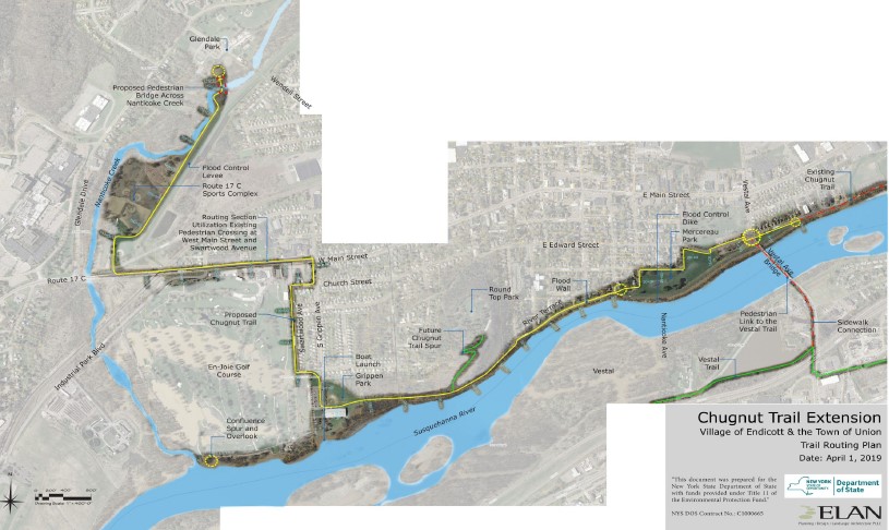
Chugnut Trail:
Starting from the Riverview Drive parking lot [Eastern End]; I have not checked this trail out yet. The paved Chugnut Trail travels West, underneath the McKinley Ave Bridge and beside the Susquehanna River and follows the flood wall west for 0.7 miles before exiting onto River Terrace. Two Rivers Greenway Map Board. Follow River Terrace West, across Vestal Ave, and you'll pick up the paved trail on your left after 0.9 miles. The trail travels through Mercereau Park and out to S Loder Ave after 1.2 miles.
Note; Future construction will continue the trail West, alongside the Susquehanna River to Roundtop Park & Grippen Park. It will then turn north inland to the Route 17C Sports Complex. Lastly it will continue North, to Glendale Park. Another section will continue West, from Grippen Park to En-Joie Park at the confluence of Nanticoke Creek.
HH
CLICK HERE FOR TWO RIVERS GREENWAY MAP
CLICK HERE FOR OTSININGO PARK TRAILS MAP
CLICK HERE FOR VESTAL RAIL TRAIL & CHUGNUT TRAIL MAP
BEFORE YOU SET OUT BE SURE TO READ THE
WAIVER OF RESPONSIBILITY AND DISCLAIMER
BIKE IT OR HIKE IT