TONAWANDA & NORTH BUFFALO RAIL TRAILS:
NORTH BUFFALO SPUR TRAIL:
WILLIAM GAITER PARKWAY PATH:
NORTH BUFFALO-TONAWANDA, NEW YORK
-BIKE IT OR HIKE IT-
Last Updated: October 27, 2025
Length: Tonawanda & North Buffalo Rail Trails; 5 miles (5.8 miles to Canalway Trail)
Minnesota Linear Park Trail; 0.6 miles
McCarty Park/William Gaiter Parkway Path; 2.1 miles
Difficulty: Easy. Flat paved rail trail.
Directions:
To Start from the NFTA-METRO Park-N-Ride lot in North Buffalo for the North Buffalo Rail Trail & Spur Trail [Southern End]; From I-290 take exit 7A to Route 5 west and travel 3.6 miles to the NFTA-METRO Park-N-Ride lot on your right. Go to the rear of this lot where you'll find both trailheads. The North Buffalo Rail Trail starts at the NW corner and the North Buffalo Spur Trail is at the NE corner (although the trail actually begins off Route 5 next to LaSalle Metro Station.
To Start from the State Street parking lot in Tonawanda for the Tonawanda Rail Trail [Northern End]; From I-290 take exit 2 to Route 425 north. Take the Ellicott Rd exit and turn left. Cross Young St to State St and the parking lot is on your right.
The Tonawanda & North Buffalo Rail Trails follows the rail bed of the former NY & Erie RR. The North Buffalo Rail Trail begins in North Buffalo, heading North, before quickly crossing into Tonawanda where the Tonawanda Rail Trail continues. For some reason the two towns didn't combine resources as the Tonawanda Map signs don't include North Buffalo. From the Northern End of the Tonawanda Rail Trail, a short 0.8 mile on-road section will connect you Northwest, to the Canalway Trail; Rochester-Buffalo . The short Minnesota Linear Park Trail runs parallel to the North Buffalo Rail Trail in North Buffalo. You can also connect South, on-road, to McCarty Park and the William Gaiter Parkway Path in North Buffalo along the old RR Right of Way. For more information visit; TONAWANDA RAIL TRAIL & NORTH BUFFALO RAIL TRAIL .
Tonawanda & North Buffalo Rail Trail:
Starting from the NFTA-METRO Park-N-Ride lot in North Buffalo [Southern End]; The trailhead is located at the NW rear corner of the lot.
Note; You can connect to McCarty Park and the William Gaiter Parkway Path by traveling South, on-road. See Below.
Note; The Minnesota Linear Park Trail starts off Route 5 and travels North, through the NFTA-METRO Park-N-Ride lot to the NE rear corner. See Below.
The paved North Buffalo Rail Trail travels North, along an open corridor passing by a side trail on your left to Shoshone Park. Come to an intersection and some old RR abutments where a RR Bridge once crossed at 0.3 miles.
Note; Left, a paved trail leads Southwest, to Taunton PL. Right, is where the Northern End of the Minnesota Linear Park Trails joins the North Buffalo Rail Trail.
Continuing North, brings you to Kenmore Ave in Tonawanda, where the Tonawanda Rail Trail begins at 0.7 miles. Map Board located here and at all street crossings. Kenmore Ave parking lot located here as well. The 0 Mile Marker for this section begins here. Mile Markers every 0.5 miles. Continue North, along an open residential urban corridor. Cross Englewood Ave and you'll pass by Lincoln Park at 1.6 miles.
Note; A paved trail travels East, into Lincoln Park, where you'll find sports fields, a pool, arena and splash park.
Continuing North, you cross Sheridan Drive at 2.3 miles, Colvin Blvd at 2.8 miles and Brighton Rd at 3.1 miles. A berm along your left blocks views of Elmlawn Memorial Park (cemetery) and to your right is Walter Kenney Field. Here the trail is a bit more isolated and industrial/commercial. Travel underneath I-290 at 3.6 miles before coming to the State Street parking lot at 4.6 miles. I haven't checked out this next section. The trail continues out through the parking lot and across Maple St and Glenwood Ave before it crosses Young St where you'll find a Map Board. Here the trail crosses an old RR bridge over Ellicott Creek. A Spur Trail on your right leads down to Eastern Park (parking lot, picnic pavilion and Kayak launch). It continues North, below the RR line bringing you to Fillmore St at 5 miles. To continue to the Canalway Trail head left, on-road, underneath the RR bridge along Fillmore St (low traffic/sidewalk available) and travel Northwest. Signs mark this route. This will bring you to E Niagara St, across which is the Canalway Trail; Rochester-Buffalo at 5.8 miles.
Minnesota Linear Park Trail:
Starting from Route 5 (Main Street) next to the LaSalle Metro Station [Southern End]; The green, paved Minnesota Linear Park Trail travels North, through the NFTA-METRO Park-N-Ride lot, to the NE rear corner where the trail exits the lot, passing by Custer St and following a tree-lined pathway through Minnesota Linear Park in the University Heights neighborhood. To your left is all woodland and your right is all residential. The trail then intersects with the North Buffalo Rail Trail after 0.6 miles.
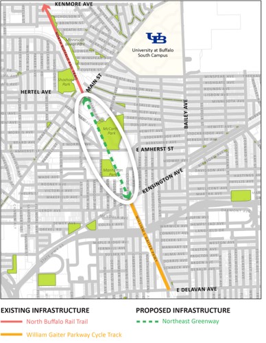
McCarty Park/William Gaiter Parkway Path:
Starting from Route 5 (Main Street) next to the LaSalle Metro Station;
Note; The 1 mile Northeast Greenway, which will continue the trail South, is under design in 2023 and will connect to the William Gaiter Parkway Path. See Map Below & GOBIKE .
Heading South; As of 2024, a Detour is required. This section detours around the old rail bed which is not accessible. Cross Main St and travel up La Salle Ave. Take your first right, on-road, along William Price Pkwy (residential) which will bring you up to a circle at 0.4 miles. Here you'll find a paved path leading to McCarty Park. Here you'll find a paved trail encircling some ball fields. Head right, South, along this circle trail to an intersection and keep straight past the McCarty Park parking lot, a playground and tennis courts. At the next intersection turn right past some basketball courts and exit the park to E Amherst St at 0.8 miles. You'll have to detour around the next section of old rail bed as well, by heading left, East, on-road (sidewalk available) and taking your first right, South, on-road along Clarence Ave (residential). This brings you to Kensington Ave. Travel right a short distance to Clyde Ave. A cross-light will then bring you over to the William Gaiter Parkway Path at 1.3 miles. This paved path travels South, alongside the Pkwy utilizing the old RR Right of Way. Travel underneath the Kensington Expy at 1.6 miles before coming to E Delavan Ave at 2.1 miles where the trail ends. The old rail bed continues South, but is not accessible.
HH
CLICK HERE FOR TONAWANDA RAIL TRAIL MAP
BEFORE YOU SET OUT BE SURE TO READ THE
WAIVER OF RESPONSIBILITY AND DISCLAIMER
BIKE IT OR HIKE IT