STATEN ISLAND BIKE TRAILS:
GREENBELT TRAIL:
NEW SPRINGFIELD GREENWAY:
BROOKFIELD PARK TRAILS:
FRESH KILLS PARK NORTH TRAIL:
STATEN ISLAND, NEW YORK
-BIKE IT OR HIKE IT-
Last Updated: October 22, 2025
Length: New Springfield Greenway; 3.3 miles
Greenbelt Trail; 2 miles
Greenbelt Trail/BIKE LANES/New Springfield Greenway Loop; 5 mile Loop
Brookfield Park Trails; Eastern Loop Trail; 1.6 miles.
Brookfield Park Trails; Western Loop Trail; 1 mile
Brookfield Park Trails; Eastern & Western Loop Trails combined; 3.3 mile Loop.
Fresh Kill Park North Trail;
Difficulty: Greenbelt Trail; Easy. Mostly flat stone-dust trail with some slight hills.
New Springfield Greenway; Easy. Flat paved trail.
Brookfield Park Trails; Easy. Flat paved trails.
Directions:
To Start from the Greenbelt Trail parking lot [Southern End]; From Route 440 take exit 4 to Arthur Kill Rd and head east for 2.5 miles. Turn left on Richman Ave and take your first right on Forest Hill Rd. The entrance to the parking lot is on your right.
To Start from Brookfield Park [Southern End]; From Route 440 take exit 4 to Arthur Kill Rd and head east for 3.1 miles. Turn left into Brookfield Park and go to the Northeastern parking lot on your right.
To Start from the Freshkills North Mound Trail parking lot [Northwestern End];
Northbound: From Route 440 take exit 7 to E Service Rd to Victory Blvd. Travel right and take your 2nd right on Roswell Ave. Follow to Wild Ave and head right, back to E Service Rd. Turn left to the parking lot.
Southbound: From Route 440 take exit 7 to Victory Blvd. Travel left and take your 2nd right on Roswell Ave. Follow to Wild Ave and head right, to E Service Rd. Turn left to the parking lot.
There are 4 Trails all clustered in the Center of Staten Island, around New Springfield. The New Springfield Greenway travels North, along the Eastern Edge of Freshkills Park, paralleling Richmond Ave. The Greenbelt Trail winds Northeast, through LaTourette Park & Latourette Park. The GREENBELT TRAIL utilizes both these parks, along with High Rock Park, Willowbrook Park, Deere Park & Reed's Basket Willow Swamp Park and is mostly a hiking trail. This is the only section on which bike-riding is permitted. Brookfield Park was once the site of a municipal solid waste facility, but has now been reclaimed with trails winding around open fields and marsh. Two paved trails encircle the park, the Eastern & Western Loop Trails. Fresh Kills Park North Trail (I haven't checked out these trails yet) travel through Freshkills Park, which is almost three times the size of Central Park. It also has a significant history as the site of the Fresh Kills Landfill, which was the largest landfill in the world before closing in 2001. For more information visit; BROOKFIELD PARK and FRESHKILLS PARK .
Greenbelt Trail/New Springfield Greenway Loop:
Starting from the Greenbelt Trail parking lot [Southern End]; To access the trail, travel East, along the entrance road, past the ball field to where the Greenbelt Trail crosses this road. I have combined the Greenbelt Trail & New Springfield Greenway to create a Loop.
Note; Heading right, West, the stone-dust Greenbelt Trail takes you 0.25 miles out to Richmond Ave, where you can access the New Springfield Greenway. This is also where I Looped back from.
Heading left, East, the stone-dust Greenbelt Trail travels though woodland before coming to a Spur Trail at 0.6 miles.
Note; Heading right, East, takes you 0.7 miles to Old Mill Rd.
Continuing straight, Northeast, you'll cross a small stream before passing by Latourette Golf Course. Cross Richmond Hill Rd at 1.2 miles. Trail now parallels Forest Hill Rd and Latourette Park. After 1.9 miles you come to the intersection of Forest Hill Rd and Rockland Ave. To continue your Loop, follow a BIKE LANE left, West, downhill along Rockland Ave. "Green" New Springfield Greenway signs mark the route. After 2.2 miles the BIKE LANE turns left, South, on Kelly Blvd, then right, West, downhill along Travis Ave. Just before Richmond Ave turn left, South, on-road, along Steinway Ave. Come to Nome Ave and turn right, West, along a BIKE LANE to a cross-light over Richmond Ave, where you'll connect to the New Springfield Greenway at 3.3 miles.
Note; The New Springfield Greenway continues both North & South from here.
To complete your Loop head left, South, along the paved New Springfield Greenway, as it travels alongside Richmond Ave. The William Davis Wildlife Refugee is along your right. It briefly diverts around a building then continues South, to a cross light over Richmond Ave This brings you to the start of the stone-dust Greenbelt Trail.
Note; The New Springfield Greenway continues South.
Follow the Greenbelt Trail East, back to the Greenbelt Trail parking lot completing a 5 mile Loop.
New Springfield Greenway:
Starting from Arthur Kill Road and Richmond Ave [Southern End]; Closest parking area is behind the Transit Area in the Park & Ride lot.
Note; East, along Arthur Kill Rd, brings you to a Spur Trail into Brookfield Park after 0.3 miles (Caution; narrow road with no shoulder, sidewalk available). Map Board. See; Brookfield Park Trails Below.
The paved New Springfield Greenway travels North, alongside Richmond Ave. Cross Richmond Creek at 0.4 miles. Nice views of the river and marshland, as well as, Brookfield Park. After 0.7 miles you come to Forest Hill Rd.
Note; On your right is the start of the stone-dust Greenbelt Trail.
A cross-light take you over Richmond Ave where the trail continues North. After 1.9 miles the trail briefly diverts around a building. The William Davis Wildlife Refugee is along your left. Come to a cross-light at 2.2 miles across from Nome Ave.
Note; The Nome Ave BIKE LANE is part of the Greenbelt Trail. (Up Hill).
Continuing North, you come to Travis Ave, where the trail turns left, West, through the woods, before crossing Travis Ave at 2.8 miles. Head North, back through the woods, before traveling alongside residential Park Dr N. The paved trail ends after 3.3 miles at Signs Rd.
Note; A BIKE LANE continues North, along Arlene St for 1 mile to Lamberts Lane, where you can connect to Father Macris Park.
Brookfield Park Trails:
Eastern Loop Trail:
Starting from Brookfield Park [Southern End]; From the Southern End of the Northeastern parking lot, you'll find a trailhead and Map Board. A gravel trail takes you up to the paved Eastern Loop Trail. Head right, Northeast, along this wide open trail, with the old landfill (now covered in grasses) on your left and marsh on your right. Hiking trails cross the old landfill. Lots of waterfowl. After 0.8 miles the trail turns West, next to Richmond Creek and a large marsh. The trail then turns South, at 1.3 miles, before coming to an *Intersection. To complete your Loop, continue straight, back to the gravel trail and head right back to the Northeastern parking lot for a 1.6 mile Loop.
Note; To continue along the Western Loop Trail, head right, West, from the *Intersection, along the paved trail, past the pumping station and Northeastern parking lot. Then travel West, through the Northern parking lot to another Map Board.
Note; Right, North, past a gate is the pumping station road.
Continue straight to another **Intersection and the start of the paved Western Loop Trail after 1.7 miles.
Western Loop Trail:
Starting from the **Intersection, next to the Northern parking lot: [Re-zeroing Mileage] Map Board.
Note; Straight, West, the paved Center Trail, travels 0.3 miles through the center of the fields, to the Western Side of the park. In case you wish a shorter Loop.
Head right, North and you'll return to the marsh. This is also where Richmond Creek either enters or exits the pumping station. The trail turns West, then South. Pass by the Center Trail on your left at 0.5 miles.
Note; Straight, West, the paved Center Trail, travels through the center of the fields, returning to the **Intersection for a short 0.8 mile Loop.
Continuing South, then East, passing by a Spur Trail on your right at 0.7 miles, out to Arthur Kill Rd. Finally the trail turns North, back to the **Intersection, before completing your Loop of 1 mile.
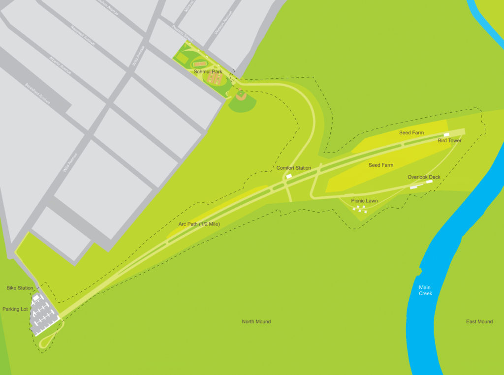
Freshkills Park North Mound Trail:
Starting from the Freshkills North Mound Trail parking lot [Northwestern End]; I have not checked out this trail yet. Restrooms.
Arc Path: This half-mile path includes separate lanes for biking and walking and breathtaking views of the surrounding grasslands and wetlands.
Bird Tower: Visitors can enjoy breathtaking views of the wetlands from this tower, made of galvanized steel columns supporting a staircase and observation platform that rises 20 feet in the air.
Wetland Overlook Deck: This fully accessible deck reaches the same elevation as the Bird Tower, allowing all visitors a view into the restored wetlands below.
HH
CLICK HERE FOR GREENBELT TRAIL MAP
CLICK HERE FOR BROOKFIELD PARK TRAILS MAP
BEFORE YOU SET OUT BE SURE TO READ THE
WAIVER OF RESPONSIBILITY AND DISCLAIMER
BIKE IT OR HIKE IT