ROCKVILLE SPUR TRAIL:
ROCKVILLE, CONNECTICUT
-BIKE IT OR HIKE IT-
Last Updated:
September 05, 2025Length: Rockville Spur; 4.3 miles
Difficulty: Easy. This old rail trail is flat and consists of stone dust.
Directions:
To start from the Colonial Road parking lot for the Hop River State Park Trail in Manchester [Western End]; From I-84 take exit 63 to Route 30. Head east to Route 83 (Oakland St) and head right. Turn left on Sheldon Rd into the industrial park. Turn right on Colonial Rd and the parking lot will be immediately on your left.
To start from the Church Street parking lot for the Hop River State Park Trail & Rockville Spur in Vernon [Southern End]; Take exit 65 off of I-84 in Vernon to Route 30. From the westbound exit take Route 30 west and from the eastbound exit take Route 30 east. Cross over the interstate via the Dobson Bridge which turns into Washington St. Immediately after crossing the bike path, turn left onto Church St. The parking lot will be a little ways down on your left. There is a map board here along with a small gazebo and picnic table.
To start from Vernon Commons in Vernon for the Rockville Spur [Southern Section]; Take exit 65 off of I-84 in Vernon to Route 30. Head east on Route 30 and take a right into the Vernon Commons Plaza and park. The trail starts just east of the parking lot where it crosses Route 30.
In 1846, the Providence & Plainfield Railroad was formed to build a railroad from Rhode Island into Eastern Connecticut. Before construction had even begun, the Western terminus had been expanded to Willimantic, then to Hartford, then to Waterbury with the intent of eventually going to the Hudson River in New York. The Connecticut portion of the route was chartered to the Hartford & Providence Railroad in 1847. Construction began in Hartford that year, building both eastward towards Providence and westward towards Waterbury. In 1849, the New York & Hartford Railroad merged with the Hartford & Providence Railroad to become the Hartford, Providence & Fishkill Railroad. On December 1, 1849 the initial segment of the Hartford, Providence & Fishkill Railroad between Hartford and Willimantic was opened for business. Meanwhile, back in Vernon, in February, 1856, a group of Rockville businessmen began planning the best route for a railroad to connect Rockville, which was already quite industrialized, to the Hartford, Providence & Fishkill Railroad at Vernon Depot. The Rockville Railroad was chartered in 1857, but a national depression prevented its construction until 1862. Once the line was completed, the Rockville Railroad went into operation in August 1863. The Rockville Spur splits off the Hop River State Park Trail in Vernon, traveling North, into Rockville. For more information visit; VERNON GREENWAYS , VERNON DEPOT and CT RAIL TRAIL EXPLORER .
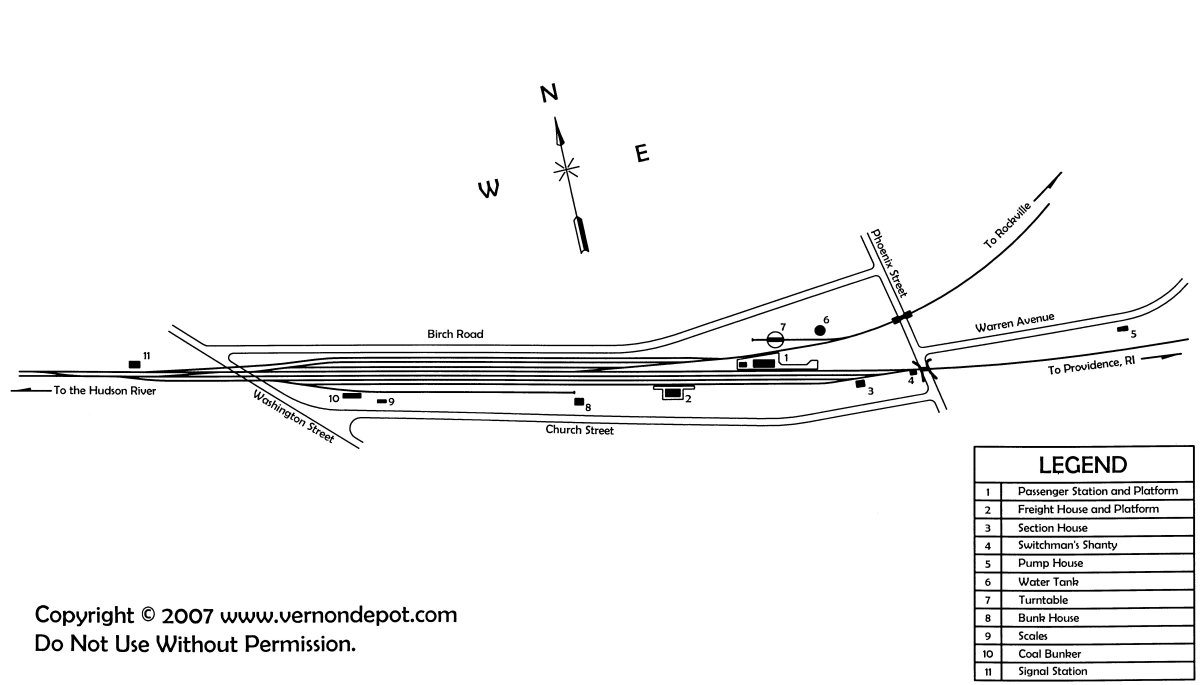
Starting from the Church Street parking lot in Vernon for the Hop River State Park Trail & Rockville Spur Trail [Southern End]; This was the site of the old Hartford, Providence & Fishkill RR Vernon Depot. Picnic tables, Map Board, Porto-Potty, picnic table, BIKE STATION and a pavilion are all located here, along with the old stone block remains of the old RR Roundhouse, + See; RR Roundhouse Below. If you head down to the old RR Roundhouse and look right, East, you can still spot the old Rockville Railroad rail bed. See; VERNON DEPOT MAP .
This is where the 0 Mile Post for the Rockville Spur Trail originates from. The Rockville Spur Trail utilizes a short section of the Hop River State Park Trail, as the old rail bed is inaccessible.
Note; Heading West, the stone-dust Hop River State Park Trail travels 2.4 miles to the Colonial Road parking lot in Manchester. See; Hop River State Park Trail .
Both the stone-dust Hop River State Park Trail & Rockville Spur Trail travel East, passing by Mile Marker 18 (Hop River State Park Trail) before crossing Phoenix St at 0.1 mile.
Note; The Hop River State Park Trail continues East, to Willimantic.
The paved Rockville Spur Trail turns left, down to Warren Ave, then right to a cross-walk. Here you travel North, up a short hill to Mile Marker 0.25 miles. Wooden Mile Markers are located every 0.25 miles. The trail reverts to stone-dust here. Cross an old railroad bridge over the Tankerhoosen River, which overlooks Tankerhoosen Lake, before passing by the Tankerhoosen Road parking lot at 0.7 miles. You then travel underneath I-84 through two tunnels (check out the artwork wall) and come to Route 30 at 0.9 miles. The Vernon Commons Plaza parking lot is located here on your left. Cross Route 30, where the trail travels along a wooded residential corridor, crossing Ogden Brook after 1.6 miles. You'll cross over Center Rd followed by Regan Rd before the trail then passes through a small valley. You'll pass a foot trail up to Rockville High School Upper Fields on your left, followed by another foot trail up to Rockville High School Lower Fields on your left at 2.9 miles. After you travel under some transmission lines, you'll come alongside some old buildings to your left.
Note; This is where another rail line split off heading West, towards Old Town Rd.
The trail turns East. You'll cross West St at 3.5 miles as the trail becomes more urban. The trail briefly travels alongside Nye & Spring Streets before heading back into woods. You then dip down to cross over Rau St and head back up a short embankment where the trail now runs alongside a heavily wooded hillside. Below to your left are a series of old mill buildings that were built along the Hockanum River to utilize water power. The trail ends abruptly after 4.3 miles at an abutment overlooking Vernon Ave where a RR bridge used to be. If you look down to your right you'll see where a brook crosses underneath the trail and emerges on the left via a stone conduit. There is a small path to your left that leads down to Vernon Ave.
Old Railroad Equipment:
+ RR Roundhouse:
A RR Roundhouse is a building with a
circular or semicircular shape used for servicing and storing trains. They could
have only a few stalls or as many as 50. Locomotives would be serviced with the
front of the locomotive pointing outward and the tender of the locomotive facing
the Turntable. RR Turntables are bridges that spin and are used
for turning locomotives and rolling stock.
HH
CLICK HERE FOR ROCKVILLE SPUR TRAIL MAP
CLICK HERE FOR HOP RIVER STATE PARK TRAIL MAP
BEFORE YOU SET OUT BE SURE TO READ THE
WAIVER OF RESPONSIBILITY AND DISCLAIMER
BIKE IT OR HIKE IT