PENWOOD STATE PARK:
BLOOMFIELD, CONNECTICUT
-BIKE IT OR HIKE IT-
Last Updated: October 29, 2026
Length: Old East & West Park Road Loop; 4.3 mile Loop
Difficulty: Old East & West Park Road Loop; Difficult. Mountain bike recommended. Not recommended for kids on bikes. The old roads are in rough shape. Some long, steep sections.
Lower Red Trail; Easy. Mostly flat, crushed gravel trail.
Directions:
From I-84 take exit 50 to Route 44 west for 2.5 miles. Turn right on Route 189 north and go 0.8 miles. Turn left onto Route 185 west and go 5 miles. The park entrance will be on the right, look for the sign. The Park Entrance parking lot [Southern End] is on your right. To park at the Penwood Pond parking lot, go up the narrow East Side Road to the right of the closed gate. Come to an intersection and head left up to the parking lot after about 1.5 miles.
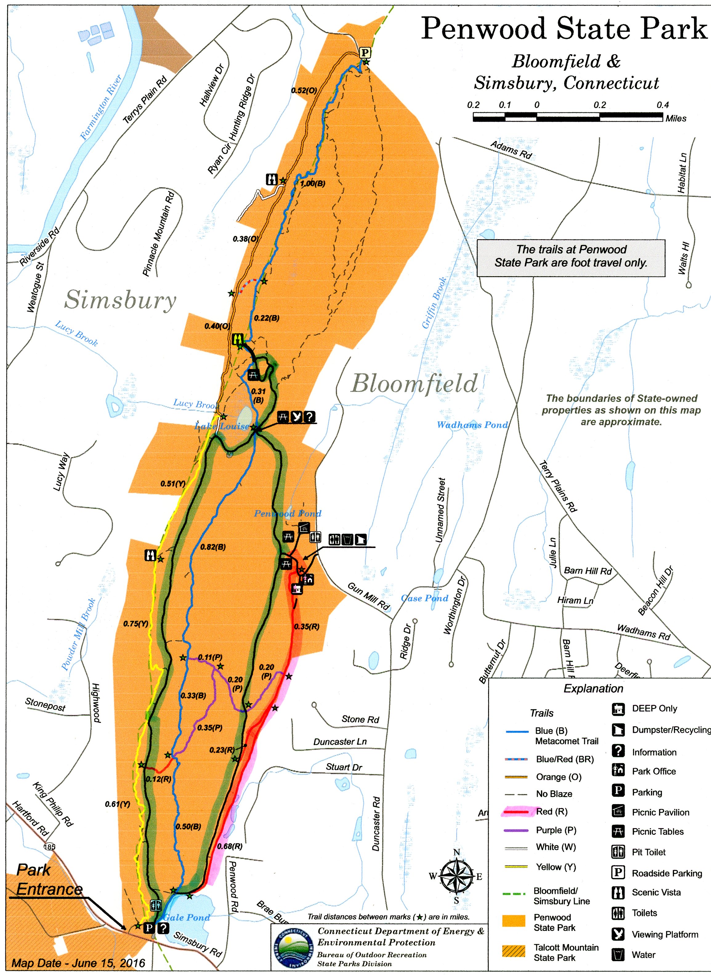
The Penwood SP Loop Trail mostly follows old roads through the park, leading to the Pinnacle. The Ranger Station is located at the Shadow Pond parking lot, along with facilities and picnic tables. For more information visit; PENWOOD STATE PARK .
Starting from the Park Entrance parking lot [Southern End]; The closed gate on your left leads to the Old West Side Park Road (closed to traffic). Travel right, North, along the East Side Road (low traffic) past Gale Pond along your right. After only 0.1 miles, you'll pick up the Lower Red Trail on your right.
Note; You have the option to utilize the paved East Side Park Road (low traffic), however it requires a slight hill climb. Come to the *Old East Side Road Gate at 1.3 miles.
The crushed gravel Lower Red Trail follows a mostly level grade alongside the ridge (similar to a railbed). Occasional tree root & rock. Pass by an intersection on your left at 0.8 miles. This leads up to the East Side Park Road. Here you'll continue along a wide, dirt park road to an intersection. Continue left, along a narrow trail that brings you up to the Penwood Pond Area road.
Note; Right, brings you to the Ranger Station.
Travel left, passing by the restroom building on your right and coming to an intersection.
Note; Right, will bring you to the Penwood Pond parking lot. Picnic area and picnic pavilion located here.
Continue straight to East Side Road, where the *Old East Side Road Gate is located at 1.3 miles. You'll continue North, up the old paved Old East Side Road. This is a steep climb and the road is in poor condition. Come to a **Map Board and picnic table at 1.8 miles, behind which is a boardwalk that leads out to a platform overlooking Lake Louise. The "blue" Metacomet Trail crosses here.
Note; The Old West Side Road begins here on your left, heading South. I utilize this old road later. See; Below.
Continue right, North, past the old stone column, uphill along the Old East Side Road. After about 0.25 miles the trail splits. This is actually just a Loop and you will return back to this point. Continue right, Northeast, up a steep, short section of the old road (narrow, bad shape), where you'll level off. This is the Northern End of the Loop at 2.1 miles.
Note; To your right, North, is the "blue" Metacomet Trail that takes you up a short hike to the Pinnacle. A very scenic overlook of the Farmington River Valley, with a view of Talcott Mountain and the Heublin Tower to the left.
Continue Southwest, down a less steep section of the old road, then back to the **Map Board, completing the Loop, at 2.5 miles.
You have 2 Options from here:
Option 1; You can head left, South, back down the Old East Side Road returning to the Park Entrance parking lot after 4.3 miles. Mostly all downhill.
Option 2; To complete the Loop, head right, South, along the Old West Side Road, however, the pavement is in much worse shape and you still have some climbing to do if you choose to follow this route. You'll encounter another steep hill. Pass by a picnic table and bench on your right at 3 miles.
Note; Next to the bench, you can follow a crushed gravel trail up to Cedar Ridge Overlook and Yellow Trail. Picnic table here, along with great views of the Farmington River Valley.
Continuing South, it's mostly downhill except for a couple of slight hills. Return to the Park Entrance parking lot after a 4.3 mile Loop.
HH
CLICK HERE FOR PENWOOD SP LOOP MAP
BEFORE YOU SET OUT BE SURE TO READ THE
WAIVER OF RESPONSIBILITY AND DISCLAIMER
BIKE IT OR HIKE IT