NORWALK RIVER VALLEY TRAIL:
NORWALK-WILTON-RIDGEFIELD-REDDING-DANBURY, CONNECTICUT
-BIKE IT OR HIKE IT-
Last Updated: March 26, 2026
Length: NRVT; Norwalk Section; 5.7 miles
Oyster Shell Loop Trail; 0.7 miles
NRVT; Wilton; Southern Section; South: 0.7 miles
NRVT; Wilton; Southern Section; North: 0.3 miles
NRVT; Wilton Center Loop; East Side; 2.2 miles
NRVT; Wilton Center Loop; West Side; 3.2 miles
NRVT; Ridgefield Section; 0 miles
NRVT; Redding Section; 0.8 miles
NRVT; Danbury Section; 0 miles
Difficulty: NRVT; Norwalk Section: Easy. Flat paved trail.
NRVT; Wilton; Southern Section; South: Moderate. Crushed gravel trail. Hilly.
NRVT; Wilton; Southern Section; North: Easy. Flat, crushed gravel trail.
NRVT; Wilton Center Loop; East Side; Moderate. Crushed gravel trail. Hilly.
NRVT; Wilton Center Loop; West Side; Easy. Crushed gravel trail. Some on-road sections.
NRVT; Ridgefield Section;
NRVT; Redding Section; Moderate. Wide, crushed gravel trail w/some hills.
NRVT; Danbury Section;
Directions:
To Start from Veterans Memorial Park & Marina or Calf Pasture Beach in Norwalk [Southern End]; From I-95 take exit 16 to East Ave south for 0.5 miles.
For Veterans Memorial Park & Marina; Continue on East Ave to Seaview Ave and turn left. Park entrance will be on your left just past the marina. Parking Fee.
For Calf Pasture Beach; Turn left on Cemetery St to Gregory Blvd. At the traffic circle follow Cafe Pasture Beach Rd south to the Park entrance after 1.8 miles. Parking Fee.
To Start from Union Park or Mathews Park in Norwalk [Central Section];
From Route 7 Northbound take exit 1 to Belden Ave and turn right. Next, turn right on Byington PI, then right alongside Union Park. To reach Mathews Park continue along Belden Ave which becomes West Ave. The park entrance will be on your left.
From Route 7 Southbound take exit 1 to Van Buren Ave and head left. Next, turn left on Union Park S, then left alongside Union Park. To reach Mathews Park continue along Van Buren Ave to Connecticut Ave. Turn left and travel underneath Route 7. The park entrance is on your right.
To Start from the Chipmunk Lane parking lot in Wilton for the NRVT; Wilton; Southern Section; South [Center Section]; From the junction of Routes 7 & 15, travel north, along Route 7 to Grist Mill Rd and head left. Take your first right on Old Belden Rd, then your first right on Kent Rd. Take your next right on Chipmunk Ln and look for the parking lot on your right.
To Start from the Route 7 commuter lot or Merwin Meadows Park in Wilton for the NRVT; Wilton Center Loops [Southern End] & NRVT; Wilton; Southern Section; North [Northern End]; From the junction of Routes 7 & 33 in Wilton head north on Route 7. Just before you reach Route 106 (Wolfpit Rd) turn left into the commuter lot.
To start from the Picketts Ridge Road parking lot in Redding for the NRVT [Northern End]; From the junction of Routes 7 & 35, in Ridgefield, follow Route 7 south and take your first left on Great Pond Rd. This becomes Picketts Ridge Rd. The parking lot will be on your right as you head down a hill.
The Norwalk River Valley Trail (NRVT) will provide a 30 mile route for cyclists, hikers, and walkers from Calf Pasture Beach in Norwalk, North, to Danbury. For more information visit; NRVT . The planned Norwalk River Esplanade is a paved trail running North-South, along the Eastern Side of the Norwalk River. This trail is currently disjointed and not complete.
Norwalk Section:
Starting from Calf Pasture Beach [Southern End]; A sidewalk follows the beach from the pier North, to Shady Beach Park. Sports fields, playground and refreshments. Heading out the entrance a BIKE LANE on Calf Pasture Beach Rd takes you North. Pass by Ludlow Park and come to a traffic circle at 0.7 miles. Continue North, on Gregory Blvd (wide shoulder) to 1st St (no shoulders) and head left. Turn right on Seaview Ave (narrow shoulder) and come to the entrance for Veterans Memorial Park & Marina after 1.4 miles. Enter the park and follow the park road South, past multiple parking lots. When the road turns right, head left where you'll pick up a paved trail which follows the Norwalk Harbor's edge around the park. Whenever the trail splits you go either way. (Note; the river’s edge trail is in poor shape along here). The trail then rejoins the park road heading North, past the boat launch and exiting the park onto Washington St (Route 136). Head right, East, via a BIKE LANE to the intersection where you'll find a cross-light, then travel left, West, back along Washington St (BIKE LANE) past Constitution Park. Cross the Washington Street Drawbridge over the Norwalk River and come to N Water St after 2.3 miles. On your right, North, you'll pick up the paved Norwalk River Valley Trail which quickly becomes a boardwalk as you pass by the Sheffield Island Lighthouse Ferry dock; See: NORWALK SEAPORT ASSOC . Lots of informational signs. Return to N Water St and continue right, on-road (low traffic) traveling underneath the RR bridge. Pass by the MARITIME AQUARIUM and turn right. This brings you to a nice pergola and promenade overlooking the river at 2.6 miles. Great views of the RR swing bridge across the river, which we saw opening to let a tugboat pushing a barge through. A Map Board is also located here. You pick up the paved Norwalk River Valley Trail again as it follows the river North, to the *N Water Street parking lot where you'll find a playground and a wooden bridge.
Note; You may take a short detour across the wooden bridge through Oyster Shell Park along the 0.7 mile Oyster Shell Loop Trail. Come to the gravel trail and travel right, East, alongside the river, past a fishing and wooden promenade overlooking the river before the trail Loops back, West, up a knoll to a wide paved trail. Continue straight through open fields and past many sculptures to another intersection. Right continues North, out to the Norwalk River Valley Trail. Head left to a second intersection. Left leads to a brick lined oval overlooking the river. Then head right where the trail returns you to the wooden bridge and *N Water Street parking lot.
Continuing North, along the paved Norwalk River Valley Trail where it travels underneath I-95 to Science Rd. Head left across the RR tracks to Crescent St. Across the street is Pine Island Historic Cemetery. Head right on Crescent St where you'll pick up the paved trail on your left as it travels West, through Devon's Place playground in Mathews Park. Pass by the tennis courts on your left and the Mathews Park parking lot on your right before crossing a park road and passing by a wooden sculptured Map Board made by the Norwalk River Water Assoc. Travel past the Lockwood-Mathews Mansion Museum on your right before coming to West Ave.
Note; Just past this trailhead, a second trail will take you left, East, across the Norwalk River alongside I-95 to the intersection of Hendricks & East Ave. Heading left, West, on Hendricks Ave, will bring you to the Norwalk River Esplanade. The Norwalk River Esplanade is a paved trail running North-South, along the Eastern Side of the Norwalk River. The Norwalk River Esplanade is currently disjointed and not complete.
Head right past the Visitor Center/restrooms and you'll come to the parks entrance after 3.7 miles.
Note; Its worth exploring Mathews Park, which is very impressive. If you have young kids, they will love it. It contains the STEPPING STONE MUSEUM and LOCKWOOD MATHEWS MANSION .
Cross-light gets you over West Ave where the paved trail continues North, through a residential area on your right and Route 7 above on your left. After crossing Maple St and Union Park S you'll come to Union Park (parking) after 4.2 miles.
Continue North, just below Route 7, crossing busy Belden Ave, before coming to the Northern End of the Norwalk River Esplanade at 4.4 miles. Map Board.
Note; The paved Norwalk River Esplanade travels East, along the Western Side of the Norwalk River, out to Cross St. You'll need to travel either left or right on-road (sidewalk available) to access a cross-walk over this busy road. A cement trail then continues alongside Norwalk River out to Burnell Blvd. A wide cement trail then crosses over the river to Irving Freese Park on your right. A narrow paved trail travels South, along the Western Side of the river, through this pocket park out to Main & Wall Streets after 0.5 miles. A Gap exists here to the next section. Note; The Norwalk River Esplanade is currently disjointed and not complete past here.
The trail then travels West, underneath Route 7, next to the Norwalk River and out to Riverside Ave. Continuing North, you travel between the river and road. You'll pass by the Riverside Ave parking lot at 4.7 miles (Map Board), before passing a small picnic area on your right. S short elevated section of trail brings you to New Canaan Ave. Cross the road and head right, East, back over the Norwalk River, where the trail continues North, on your left at 5.3 miles. The trail now follows the Eastern Side of the Norwalk River alongside an electrical sub-station and transmission line. Come to **Broad Street where the trail currently ends, as of 2025 after 5.7 miles.
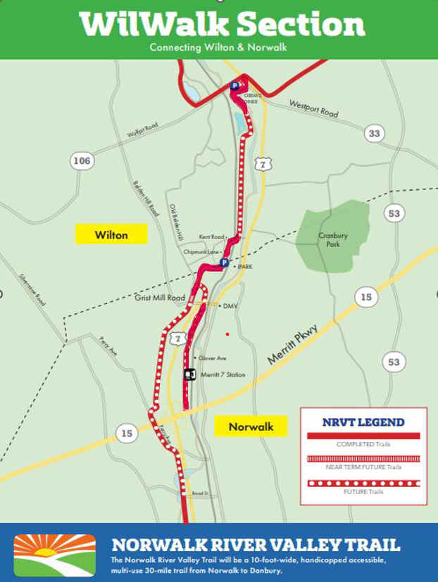
Note; The next 4.8 mile section is called the "WilWalk" and will continue the trail North, into Wilton, where it will connect to the Wilton Center Loop at the Route 7 commuter lot. 3 sections have been completed along this route, as of 2025.
WilWalk Section:
North of Route 15 in Norwalk, there will be 2 Sections of the Norwalk River Valley Trail, as you can see on the Map Above. The 1st Section, not yet constructed, will travel North, from **Broad Street, along the Western Side of Route 7 to Route 15, where it will continue North, to ***Grist Mill Road. The The 2nd Section, travels North, along the Eastern Side of Route 7, to ***Grist Mill Road. Both Sections will then connect North, to the NRVT; Wilton; Southern Section; South. See Below.
2nd Section:
Starting from Main Ave & Glover Ave; [North of Route 15] Travel West, on-road, along Glover Ave across the Norwalk River. Cross the RR tracks and continue right, North, on-road (BIKE LANE traveling South). RR tracks along your right. Travel underneath a bridge at 0.25 miles where a BIKE LANE now follows both sides of the road. Quickly pass by Oakwood Ave on your left, where you can utilize the paved Norwalk River Valley Trail along your left. Pass by the Merritt 7 Train Station on your right. At 0.9 miles, the paved trail crosses the road, where it then travels down alongside the RR tracks, before ending just below the ***Grist Mill Road bridge after 1 mile.
Note; Future plans will continue the trail underneath the ***Grist Mill Road bridge and connecting to the completed NRVT; Wilton; Southern Section; South. See Below.
Wilton Section:
NRVT; Wilton; Southern Section; South:
Starting from the Chipmunk Lane parking lot [Central Section]; This section travels both North & South, dead ending at both ends.
Heading South; The wide, crushed gravel Norwalk River Valley Trail winds through the woods, mostly uphill. You cross 3 wooden bridges, before the trail dead ends after 0.5 miles, just above ***Grist Mill Road far below.
Heading North; The wide, crushed gravel Norwalk River Valley Trail winds through the woods, crossing a wooden bridge. Long downhill section brings you to a transmission line and dead ends after 0.2 miles, just short of Kent Rd.
Note; A Gap exists North, as of 2025, to the NRVT; Wilton; Southern Section; North. See Below.
NRVT; Wilton; Southern Section; North:
Starting from the Route 7 commuter lot [Northern End]; From the back of the parking lot the wide, crushed gravel Norwalk River Valley Trail travels across an old bridge over the Norwalk River, then South, through the woods, alongside the river. The trail ends after 0.3 miles at Wilton Pitts Lake.
Note; A Gap exists South, as of 2025, to the NRVT; Wilton; Southern Section; South. See Above.
Wilton Center Loop; East Side:
Starting from the Route 7 commuter lot [Southern End]; Head out of the commuter lot to Route 7 and turn left to the junction of Wolfpit Rd. A cross-light gets you over busy Route 7 to the start of the hard packed gravel Wilton Center Loop. Map Board. Heading North, you head into the woods and soon cross Gaylord Dr. The trail winds its way up the hilly woods briefly following Chestnut Hill Brook before crossing a short boardwalk at 0.4 miles. Cross Raymond Lane after 0.7 miles. The trail continues north crossing Sharp Hill Rd at 1.3 miles. Sharp Hill Road parking lot and Map Board. Trail crests and starts a more downhill route. Cross a boardwalk and come to an intersection at 1.9 miles.
Note; Left brings you out to Twin Oak Lane parking lot. Map Board.
Continuing straight the trail currently ends at a bridge just before Skunk Lane at 2.2 miles. Future plans call for continuing the trail North, 1 mile, to Pimpewaug Rd in 2025.
Wilton Center Loop; West Side:
Starting from the Route 7 commuter lot [Southern End]; Head out of the commuter lot to Route 7 and turn left to the junction of Wolfpit Rd. This section of the Wilton Center Loop currently utilizes on-road sections. Travel left, West, on-road (sidewalk available) along Wolfpit Rd for almost 0.4 miles to Horseshoe Rd East and turn right. On your left will be Horseshoe Road parking lot. A paved trail travels past the Southern End of the pond bringing you to Horseshoe Rd West. This residential road travels North, up the West Side of the pond to River Rd. Here, you'll pick up a narrow paved trail which travels North, alongside River Rd. River Rd becomes Old Ridgefield Rd at 1.2 miles where you continue on-road (sidewalk available) through the quaint downtown. When you come to a wide intersection with a small island continue straight along Center St. Immediately take your first right into Old Post Office Square (spot an NRVT sign) and travel through the parking lot where you'll pick up the hard packed gravel Wilton Center Loop as it travels underneath Ridgefield Rd next to the Norwalk River at 1.5 miles. Travel through Merwin Meadows Park past a soccer field and across the Comstock Brook where you'll pass a beach and playground before coming to the Merwin Meadows Park parking lot at 1.8 miles. Travel through the parking lot and you'll come to a Map Board. The wide gravel trail continues to the left of the Map Board heading into the woods and alongside the river. Continue straight past a spur trail on your left alongside the Norwalk River and you'll soon come to School Rd after 2.4 miles. Head right, North, on-road (narrow paved path available) to the Cider Mill School entrance, where you'll find a Map Board across the road. The narrow paved path then turns left, alongside Kristine Lilly Way. Pass by ball fields and a parking lot before coming to Catalpa Rd and Wilton High School at 2.8 miles. Cross the road to the paved path and follow it right, out to Route 7. Head left, North, utilizing the sidewalk past Wilton High School. Come to the entrance to Allens Meadows Park at 3.2 miles. Parking lot.
Note; Future plans call for continuing the Norwalk River Valley Trail North, through Allens Meadows.
The on-road portion (sidewalk available) of the Wilton Center Loop continues North, alongside Route 7 to Cannon Rd on your right at 3.4 miles. Crosswalk. The on-road portion continues East, along Cannon Rd, to
Note; Future plans call for continuing the Wilton Center Loop East, along Cannon Rd and connecting to the future Wilton Center Loop; East Side.
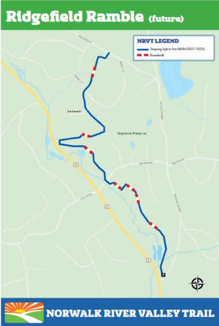
Ridgefield Section:
Ridgefield is planning to build its first section of the NRVT from the Simpaug Tpke, North, 1.5 miles, to Fire Hill Rd in Redding in 2025. See; Map Below.
Redding Section:
Starting from the Pickett's Ridge Road parking lot; Kiosk. The wide, crushed gravel Norwalk River Valley Trail travels South, downhill into the woods. The hilly trail winds through the woods bringing you to Fire Hill Rd, across from Bobbys Ct, after 0.8 miles South, at the Ridgefield border.
Danbury Section:
Construction planned in 2025, for a demonstration trail through Tarrywile Park.
HH
CLICK HERE FOR NORWALK SECTION MAP
CLICK HERE FOR WILTON SECTION MAP
CLICK HERE FOR RIDGEFIELD SECTION MAP
CLICK HERE FOR REDDING SECTION MAP
CLICK HERE FOR DANBURY SECTION MAP
BEFORE YOU SET OUT BE SURE TO READ THE
WAIVER OF RESPONSIBILITY AND DISCLAIMER
BIKE IT OR HIKE IT