NEW MILFORD RIVER TRAIL:
NEW MILFORD, CONNECTICUT
-BIKE IT OR HIKE IT-
Last Updated: July27, 2025
Length: New Milford River Trail: Northern Section; 1.3 miles
River Road Section; 3.6 miles
New Milford River Trail: Southern Section; 0.5 miles
Difficulty: New Milford River Trail: Northern Section; Easy. Flat hard packed gravel trail.
River Road Section; Easy. Flat hard packed dirt & gravel road.
New Milford River Trail: Southern Section; Easy. Flat paved trail.
Directions:
To start from the Young's Field Road parking lot for the New Milford River Trail; Southern Section; From Routes 7 & 202 in New Milford head east, along Route 202, across the river. Turn left on Young's Field Rd. Parking lot is on your left, next to the Trailhead.
To start from the Boardman Road parking lot for the New Milford River Trail; Northern Section [Southern End]; From the junction of Routes 7 & 202 in New Milford head north, on Route 7 for 2.3 miles. Turn right on Boardman Road and cross the river. The parking lot is on your left. A secondary parking lot is located back across the river off of Route 7, however, the old footbridge over the river is closed, so you'll have to cross the Boardman Road Bridge. To access the River Road parking lot; Continue along Boardman Rd and take your first left on River Rd. Travel just over a mile and spot a dirt road on your left that leads to the parking lot.
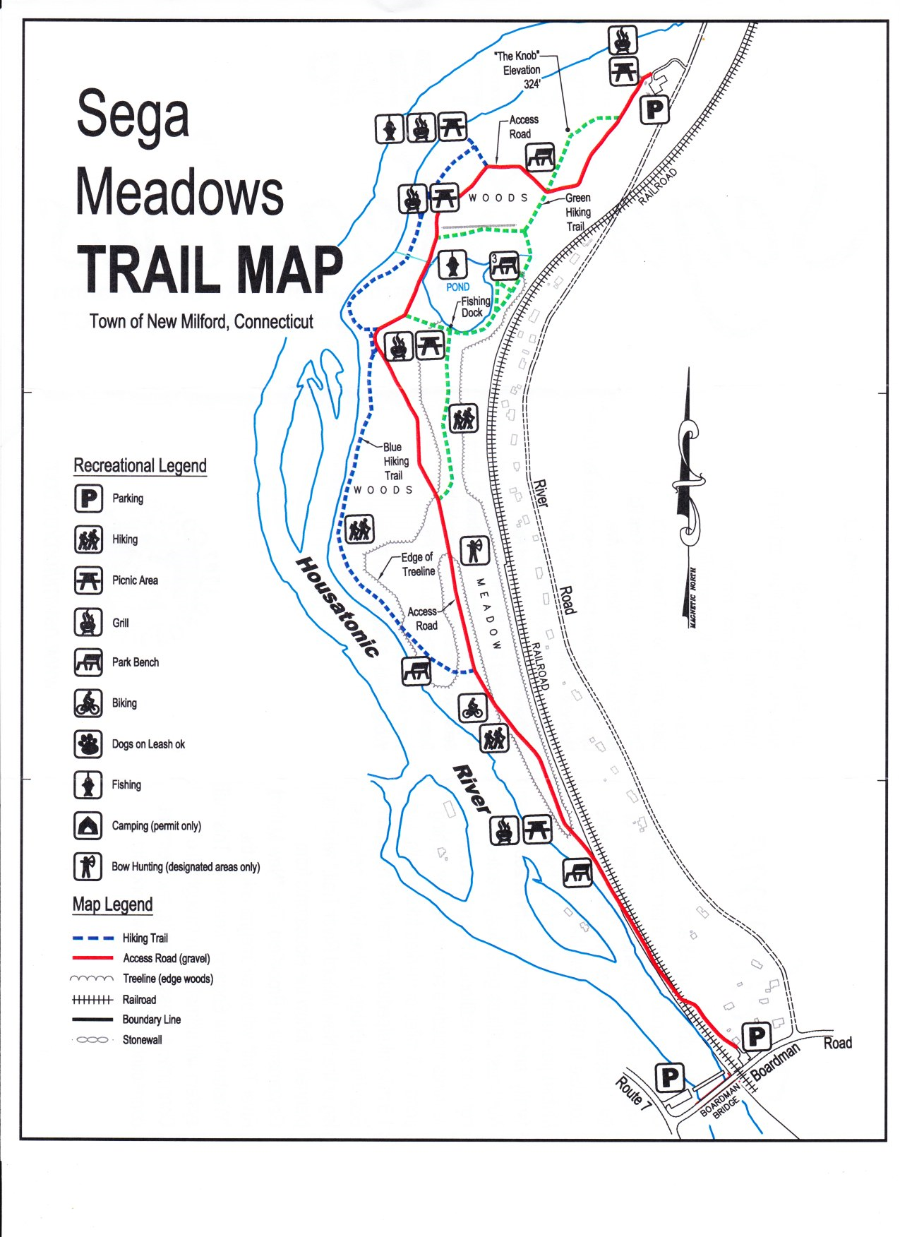
The New Milford River Trail currently consists of two sections. The Northern Section is off-road and follows the Housatonic River corridor in the town of New Milford. You can extend your trip North along River Road (low traffic dirt packed road) up to Gaylordsville. The Southern Section travels alongside the Housatonic River through Young's Field. For more information visit; NEW MILFORD RIVER TRAIL .
New Milford River Trail; Southern Section:
Starting from Young's Field Road parking lot [Southern Section]; The trail begins next to a Kayak launch for the Housatonic River.
Note; Across the road is Young's Field. Sports fields & courts, playground & Skate Park.
The paved New Milford River Trail travels North, alongside the river. Just past some picnic tables the trail turns right, across Young's Field Rd and travels up Patriots Way. Here the trail travels South, alongside the road. The trail crosses the road and continues above Young's Field. The trail ends after 0.5 miles, across from the New Milford RR Station. Here you can check out downtown New Milford.
New Milford River Trail; Northern Section:
Starting from Boardman Road parking lot [Southern End];
Note; The old historic Boardman Bridge is located next to the Route 7. This lenticular truss structure bridge was built in 1888 and is listed on the National Register of Historic Places. It is currently closed, but will hopefully be restored as a pedestrian bridge.
The New Milford River Trail travels North, past the gate into Saga Meadows Park, along an old paved road. Cross over the RR tracks where the trail surface changes to hard packed gravel. The trail travels between the Housatonic River and RR tracks for a bit before pulling away from both and traveling alongside a meadow. Take a sharp left into a Pine forest at 0.6 miles. Follow the signs. You'll hang a right with views of the river below and pass by a small pond.
Note; A Spur Trail takes you alongside the pond, which has a dock and benches.
Hang a left, at the next intersection following the "bike trail" sign. Continue straight at the next intersection up a slight knoll. At your next intersection continue straight past the gate to the River Road parking lot. Sign board here. If you head out the dirt road you'll come to River Road after 1.3 miles.
Note; You can head left, North, on-road, along the hard packed dirt & gravel River Road (low traffic) to extend your ride. It travels between the river and RR tracks, is wooded and isolated. After 2.9 miles the road becomes more residential and turns into Riverview Rd before coming to Route 7 in Gaylordsville after 3.6 miles.
HH
CLICK HERE FOR PROPOSED TRAIL MAP
BEFORE YOU SET OUT BE SURE TO READ THE
WAIVER OF RESPONSIBILITY AND DISCLAIMER
BIKE IT OR HIKE IT