
MERRIMACK RIVER GREENWAY TRAIL:
CONCORD, NEW HAMPSHIRE
-BIKE IT OR HIKE IT-
Last Updated: May 11, 2026
Length: Merrimack River Greenway Trail; 1 mile
Difficulty: Easy. Flat paved trail.
Directions:
To Start from Terrill Park parking lot [Southern End]; From I-93 take exit 13 to Route 3 and head west across the river. Turn left on Old Turnpike Rd and travel 0.3 miles to the Park entrance on your right.
The Merrimack River Greenway Trail will be a paved, continuous and primarily off-street path, roughly following the Merrimack River in Concord. It will run from the Southern End of the Northern Rail Trail South, to Terrill Park. For more information visit; MERRIMACK RIVER GREENWAY TRAIL .
Northern End:
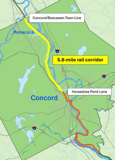
Note; Phase 3 construction will complete the trail from the Northern Rail Trail South, 1.8 miles, to Sewalls Falls Rd. Design in 2026. See; Map Below.
The city 0f Concord has purchased the 5.8 mile rail corridor. See; Map Below.
Southern Section:
Starting from Terrill Park parking lot [Southern End]; Map Board and picnic tables located here. Currently the stone-dust Merrimack River Greenway Trail travels South, through the park, alongside the Merrimack River. After passing by a "Dog Park" you come to a cement trail after 0.3 miles. Left brings you up to the Northern Side of the Route 3 Bridge. Straight takes you underneath, then up to the Southern Side of the Route 3 Bridge.
Note; If you cross the bridge over the Merrimack River (narrow shoulder/sidewalk available) you'll pick up a cement trail on your right that leads down to William A. Healy Memorial Park. I haven't checked out this park.
Note; A Gap exists, as of 2026, from the Terrill Park parking lot, North, to the completed Sunflower Section. Plans are to install a boardwalk along this Gap.
Starting from Gully Hill Road plaza [Northern End]; Map Board. The Sunflower Section is open and travels West, then South, along the Merrimack River. I haven't checked out this section yet.
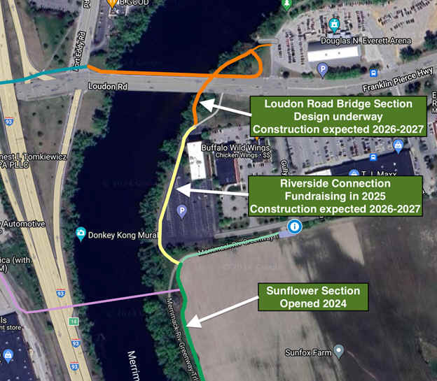
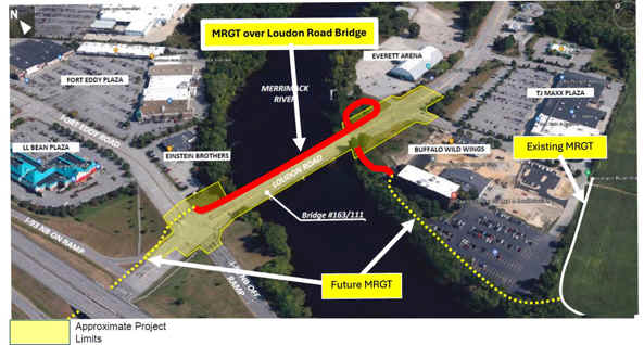
Note; In 2026, the trail will be extended North, from the Sunflower Section, along the Merrimack River to Loudon Rd, along the Riverside Connection. Future plans will then take the trail across the river via the Loudon Road Bridge Section. See; Map Above & Below.

HH
BEFORE YOU SET OUT BE SURE TO READ THE
WAIVER OF RESPONSIBILITY AND DISCLAIMER
BIKE IT OR HIKE IT