MANCHESTER & LAWRENCE RAIL TRAIL:
LAWRENCE RAIL TRAIL:
METHUEN RAIL TRAIL:
SALEM BIKE-PED CORRIDOR:
WINDHAM RAIL TRAIL:
LONDONDERRY RAIL TRAIL:
SOUTH MANCHESTER RAIL TRAIL:
MANCHESTER, NEW HAMPSHIRE to LAWRENCE, MASSACHUSETTS
-BIKE IT OR HIKE IT-
Last Updated: February 13, 2026
Length: Lawrence Rail Trail; 1.4 miles (proposed)
Methuen Rail Trail; 2.4 miles
Salem Bike-Ped Corridor; 5 miles (Currently 2 miles paved)
Windham Rail Trail; 4.4 miles
Derry Rail Trail; 4.3 miles (Currently 3.8 miles developed)
Derry Loop Trail; 4.7 miles
Londonderry Rail Trail; 6.6 miles (Currently 4.5 miles developed)
South Manchester Rail Trail; 2.4 miles
Difficulty: Lawrence Rail Trail; (to be constructed in 2025)
Methuen Rail Trail; Easy. Flat paved rail trail.
Salem Bike-Ped Corridor; Easy. Flat, partly paved rail trail.
Windham Rail Trail/Derry Rail Trail/Londonderry Rail Trail/South Manchester Rail Trail; Easy. Flat paved rail trail.
Derry Loop Trail; Moderate. Trail consists of paved sections, stone-dust sections and on-road sections. Some hilly sections.
Directions:
To start from Manchester Street Park in Lawrence [Southern End]; From I-93 in MA take exit 43 to Route 110 east. Bear left on Woodland St and follow to a traffic circle. Follow around to Manchester St, traveling underneath the old RR bridge and take your first left into the Park. Note; There are no Park entrance signs.
To start from the Main Street Municipal parking lot in Salem [Southern Section]; From I-93 take exit 2 to Pelham Rd and head east. Pelham Rd becomes Main St. Just before Route 28 the parking lot will be on your right next to Central St.
To start from the Depot Road parking lot in Windham [Central Section]; From I-93 take exit 3 to Route 111 west. Take a right on Church St and another right onto N Lowell Rd. After traveling underneath I-93 you'll come to Windham Junction. Turn right up Depot Rd and you'll spot the "Blue Caboose" on your left. The parking lot is on your right.
To start from Hood Park in Derry [Central Section]; From I-93 take exit 4 to Route 102 east. When you come to downtown look for a wide brick cross-walk. Just past this cross-walk turn left up Manning St and you'll come to Hood Park.
To start from Route 102 in Derry [Derry Loop Trail]; From I-93 take exit 4 to Route 102 east. When you come to downtown look for a wide brick cross-walk. Just before this cross-walk take a right past the old train station, now the "Depot Square Steak House" and park near the rear.
To Start from the Sanborn Road parking lot in Londonderry [Northern Section]; Take exit 5 off of I-93 to Route 28 north. Routes 28 & 128 combine. Take your second right onto Sanborn Rd. Across from the North Londonderry Elementary School is a parking lot.
To Start from the Manchester Commons Shopping Center parking lot in South Manchester [Northern End]; From I-293 take exit 1 to S Willow St (Route 28) north. Turn left when you reach Spring Garden St, then left on S Beach St. You'll immediately spot the trailhead on your left. Turn left and follow the road to a parking lot next to the trail.
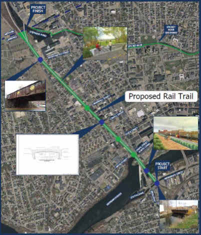
The Manchester & Lawrence Rail Trail follows the rail bed of the former Manchester and Lawrence Branch of the Boston and Maine Railroad. Starting in Lawrence, MA the proposed Lawrence Rail Trail will connect North, to the Methuen Rail Trail in Methuen, MA, which connects North, to the Salem Bike-Ped Corridor in Salem, NH, which connects North, to the Windham Rail Trail in Windham, NH, which connects Northwest, to the Derry Rail Trail in Derry, NH, which connects North, to the Londonderry Rail Trail in Londonderry, NH, which will finally connects Northwest, to the South Manchester Rail Trail in Manchester, NH. All the trail sections in NH are also part of the state wide GRANITE STATE RAIL TRAIL , a proposed 120-mile trail extending from Methuen MA Northwest, to Lebanon NH. You can also access the Spicket River Greenway in Lawrence, MA from the Southern End of the Methuen Rail Trail. From the Windham Rail Trail you can access the undeveloped Rockingham Recreational Trail and in the future the proposed Windham Greenway. From the Derry Rail Trail you can access the Derry Loop Trail. For more information visit; Methuen Rail Trail , Salem Bike-Ped Corridor , Windham Rail Trail , Derry Rail Trail , Londonderry Rail Trail & South Manchester Rail Trail . See also; Manchester Trails for Rockingham Recreational Rail Trail, Heritage Trail & Piscataquag Trail.
Lawrence Rail Trail:
[Southern End]
Construction started in August 2025, that will convert an old rail bed from the Southern End of the Methuen Rail Trail, South, 1.5 miles through Lawrence. Two bridges will be rehabbed over the Merrimack River & South Canal and a new bridge constructed over Manchester St.
Methuen Rail Trail:
Starting from Manchester Street Park in Lawrence, MA [Southern End]; A sign board and picnic tables are located here. From the parking lot travel past the community garden and playground along the paved trail to a promenade that overlooks the Spicket River with the old Arlington Mills across the river.
Note; This paved trail with a wide white stripe is part of the Spicket River Greenway's Northern Endpoint in Lawrence. It heads right, East.
A short section of this trail continues straight which is where you head. Just before a an old RR bridge that crosses the river turn left and follow a stone-dust trail back alongside the park and up an embankment. This will bring you up to the old rail bed just shy of 0.4 miles. To your left, South, is the old double track RR bridge across Manchester St.
Note; This is where Lawrence has future plans for the Lawrence Rail Trail.
Heading right from the bridge the paved Methuen Rail Trail travels North, above the river and old mills along your right. Travel underneath Oakland Ave and across Union St before passing by the old Methuen Railroad Depot (1907). You then pass by the Railroad Street parking lot after 1.5 miles. A tunnel takes you underneath Osgood & Lowell Streets. After crossing over the Spicket River you enter a Bird Sanctuary and leave the town behind. Travel underneath Route 213, then an old wooden road bridge at 2.1 miles. Travel past a large marsh and pass by the NH border post to your right as you enter Salem, NH. The trail ends after 2.8 miles at Hampshire Road. Hampshire Road parking lot located here.
Salem Bike-Ped Corridor:
Starting from Hampshire Road parking lot [Southern End] [Continuing Mileage]; Heading North, from the end of the Methuen Rail Trail cross Hampshire Rd (Use Caution; No cross-walk) to the Salem Bike-Ped Corridor.
Note; As of Feb. 2024, the Southern Section of the trail surface consists of recycled asphalt, hard packed dirt & grass surface which makes for a slightly bumpy ride.
Pass by an old RR Mileage Marker at 3 miles on your right reading M23/L4 (Manchester 23 miles/Lawrence 4 miles). These old RR Mileage Markers were located every mile along the railroad. Straight, open corridor between woods and marsh on your left and commercial to your right. Cross Kelly Rd at 3.9 miles (Use Caution; No cross-walk/Head right for a cross-walk) where the trail now along Route 28. Again, Use Caution; No cross-walk past the plaza entrance. Come to Cuff Crossing Rd at 4.6 miles (Use Caution; No cross-walk).
Note; Phase 4 will pave the trail North, from here to Rockingham Park Blvd.
The old rail bed continues along Route 28 crossing busy Rockingham Park Blvd (Route 38) at 5 miles (Use Caution; No cross-walk). Cross Main St at 6 miles (Use Caution; No cross-walk/Head right for a cross-walk) and you'll pass by the old Salem RR Depot, which is now a Transportation Museum.
Note; To your left just up Main Street is a Municipal parking lot.
Here the Northern Section of trail is paved as it travels through an open plaza past a pergola and fountain. Cross Willow St where the trail is a bit more isolated as it travels alongside a large marsh and along a causeway. Cross Old Rockingham Rd at 6.7 miles. Travel up along a berm above Route 28. Travel over a "Cattle Culver" which is a culvert built underneath the RR tracks to allow farm animals access. Informational signs located along the trail. Travel past the site of the old Canobie Lake RR Station before coming to a Map Board. A cross-light over Range Road brings you to the Windham town line and the Southern End of the Windham Rail Trail after 7.8 miles. Parking is located here, along with a BIKE STATION.
Windham Rail Trail:
Starting from Range Road [Southern End] [Continuing Mileage]; Continuing Northwest, from the end of the Salem Bike-Ped Corridor cross Range Rd and the Windham town line where the paved Windham Rail Trail continues North. The trail slowly pulls away from Route 28 before an iron bridge takes you over Route 111 at 8.3 miles where you travel through a rock cut into the woods. Cross Roulston Rd at 8.7 miles.
Note; Future plans call for constructing a parking lot here.
The trail now travels through deep woods with many marshes and rock cuts. Wooden Mile Markers are located at 0.5 mile increments. Cross a small bridge followed by a causeway through a large marsh (Flatrock Brook) at 9.6 miles. Pass by another large marsh (Mitchell Pond) and over a culvert for Flatrock Brook. Just past the 1 Mile Marker you'll find an old granite RR Mileage Marker (mile numbers have broken off). A bridge takes you over Mallard Rd. Come to the restored 1849 Windham Train Depot where you'll find a Map Board. Across from the old train station sits the restored Freight Storage building, behind which you'll find the Depot Road parking lot. Porto-Potty's located here.
Note; On your right, East, just before the old train station spot a dirt trail and a sign reading "NH snowmobile club" This leads to the undeveloped ROCKINGHAM RECREATIONAL TRAIL .
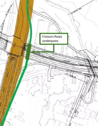
Note; Future plans call for connecting to the planned paved Windham Greenway Trail, West of here in Windham and the Rockingham Recreational Trail; Fremont Branch, East of here in Derry. See; TRAILSPOTTING; WINDHAM GREENWAY TRAIL & Map Below.

Cross Depot Rd at 12 miles passing by an old blue B&M RR caboose. A final rock cut takes you out to N Lowell Road at 12.2 miles where you'll find the wooden 0 Mile Marker. Just before this Mile Marker look East, to spot an old RR Mileage Marker reading L13/M14 which meant Lawrence 13 miles/Manchester 14 miles. These old RR Mileage Markers were located every mile along the railroad. Across the road is the start of the Derry Rail Trail.
Derry Rail Trail:
Starting from N Lowell Road [Southern End] [Continuing Mileage]; Continuing North, from the end of the Windham Rail Trail, cross N Lowell Rd (Use Caution; No cross-walk) where the paved Derry Rail Trail continues. Map Board located here along with a 0 Mile Marker painted on the trail. Head into the woods. You'll briefly lose the tranquility of the trail as you skirt close to I-93. Travel past a large pond along your right before coming to Bowers Rd after 13.7 miles. You'll need to head right, then cross the road to return to the trail. Enter a residential corridor where a cross-walk takes you over Kendall Pond Rd at 14.4 miles. Cross the junction of Norton St & Hall Ave after 14.7 miles.
Note; The Derry Loop Trail returns to the rail trail here. See Below.
Continue North, through a small rock cut and along a berm with green fencing. Beaver Brook runs below. This leads to the South Ave parking lot. Continue past the ball fields alongside a cul-de-sac and across South Ave in Derry. This brings you to the old Derry Train Station and Route 102 parking lot. Map Board located here. A wide cross-walk takes you over Route 102 at 15.2 miles. Travel through a small bricked lined garden park where you'll find a Map Board for the Derry Loop Trail. Spot an old RR Mile Marker here as well; M11/L16 or Manchester 11 miles-Lawrence 16 miles. These old RR Mileage Markers were located every mile along the railroad. The trail follows alongside Manning St & Courthouse Lane before crossing Rollins St to the Hood Park parking lot after 15.5 miles. Map Board located here.
Note; The Derry Loop Trail heads East, through the parking lot and past the basketball courts to a paved trail. SEE BELOW.
Continuing North, the trail travels along a high berm above Hoods Pond before ending near N High Street after 15.8 miles.
Note; The last 0.5 miles in Derry has yet to be developed as of 2025. Furthermore, another 0.6 miles in Londonderry is undeveloped creating a Gap. This 1 mile segment in Derry and Londonderry will be built as part of the larger "Exit 4A highway connector" development. This will include a tunnel underneath this highway.
Derry Loop Trail:
Starting from the Route 102 parking lot along the Derry Loop Trail [Re-zeroing Mileage]; Head North, across the wide cross-walk to a small garden park. Here you'll find a Map Board along with an old RR Mile Marker; M11-L16 or Manchester 11 miles-Lawrence 16 miles. These old RR Mileage Markers were located every mile along the railroad. The trail follows a brick lined path along Manning St. The old "Grainery of Derry" building is across the street. The trail can be tricky to follow at times as some of the green "Bike Route" signs are missing. The only Map I could find on-line is not as specific as the Map Board. The trail crosses the street near the courthouse and utilizes a BIKE LANE (low traffic). You'll come to Hoods Pond & Hood Park after 0.3 miles. Head right through the parking lot to the basketball courts and take the paved trail.
Note; The lower paved trail simply brings you down to the beach.
The paved trail heads into the woods, turning to gravel after 0.5 miles. Bear right and you'll emerge at the end of a cul-de-sac (Mitchell Ave). Head on-road up Mitchell Ave and turn right on Franklin St Ext, then a quick left on Lincoln St (all residential). Take the cross-walk over Crystal Ave and turn left. A quick right will bring you back to a paved path at 0.7 miles. You come to an intersection with athletic fields on your left. If you continued straight up the hill you'd come to a small playground. STOP. You need to turn left towards the fields. The paved trail ends and turns to hard packed dirt as it travels around MacGregor Park, which is part of the middle school. You return to a paved path and continue around the fields and out to Peabody Annex at 1.3 miles. This begins another on-road section (although their are sidewalks available). Follow Peabody Rd Annex to Peabody Rd and turn right. BIKE LANE. Take a left when you reach Perley Rd (BIKE LANE) and then a right when you reach Hoodkroft Dr (BIKE LANE). This brings you to E Broadway (Route 102). No cross-walk is located here and this is a busy rd, so head left along a narrow sidewalk until you come to Crescent St. Here a cross-walk will bring you over E Broadway to the Derry Fire Dept. at 1.9 miles. A paved trail runs around the right side of the FD, past the cell tower and out to S Main St (Route 28 Bypass). Take the cross-walk over S Main St and turn right along the paved trail which parallels the road. At 2.4 miles you turn left into Derry Village Elementary School. The trail then crosses right in front of the school and heads uphill through the woods and passes in front of West Running Brook School. The trail heads right, out the entrance, to a cross-walk over S Main St. Turn right and follow the paved trail to Fairway Dr. Head left down the paved trail. Just before the road takes a sharp left, the trail turns right into an apartment complex and changes to a hard packed surface before heading through a Pine stand. After crossing a wooden bridge you head up a short hill and come to the Alexander Carr Playground, located at the end of Pierce Ave, after 3.5 miles. A parking lot is located here. From the parking lot the paved trail head left through a Red Pine stand, past another playground, tennis courts and out to Birch St. A cross-light takes you over to Summit Ave where you start an on-road (residential) segment. From Summit Ave take a right on Berry St, then a left on Norton St/Hall Ave. This will bring you back to the Derry Rail Trail at 4.2 miles. Turn right and follow the rail trail back to Route 102 for a 4.7 mile Loop.
Londonderry Rail Trail:
Currently, as of 2025, there is a 1 mile Gap between the current Southern End of the Londonderry Rail Trail at Route 28 & the Northern End of the Derry Rail Trail on N High Street. Phase 7 is a 0.6 mile section that connects Seasons Ln South, to Rt. 28, though to Franklin St. Ext. at the Derry Town Line. This will include the construction of a safe pedestrian crossing across Rt. 28.
Starting from Route 28 [No parking located here] [Southern End] [Re-zeroing Mileage]; Heading Northwest, the paved Londonderry Rail Trail travels underneath 2 large power lines before heading into the woods. Pass an old RR Mileage Marker L18/M9 (Lawrence 18 miles/Manchester 9 miles) on your right before passing by the Beaver Brook Marsh on your left at 0.4 miles. These old RR Mileage Markers were located every mile along the railroad. After traveling along a causeway between another marsh you'll pass by a Spur Trail on your right to the Independence Drive parking area at 1.4 miles before crossing Liberty Dr. Here the trail travels alongside Independence Dr before crossing Auburn Rd and continuing alongside Verani Way past a scenic pond into the woods at 1.8 miles. You then travel underneath I-93 as the trail turns west. Pass by the Exit 5 Park n Ride parking lot at 2.2 miles before crossing Symmes Dr. Look right to spot old RR Mileage Marker L20/M7 before passing a marsh on your right. Next cross Enterprise Dr, followed by Clark Rd. More marsh and a couple of brook crossings before passing a Spur Trail on your right to the Sanborn Road parking lot at 3.2 miles. Pass by an old cement RR Whistle Post on your right before you cross Sanborn Rd and Route 28 (Cross-light). + See; RR Whistle Post Below. Cross Mammoth Rd into heavy woods. Cross a causeway through Little Cohas Marsh at 4 miles passing by a small dam. Just past a medium berm pass by RR Mile Marker M5 on your left before coming to Harvey Road at 4.5 miles. Nice view of the runways.
Phase 6 will continue the trail across Harvey Rd, then North, alongside the Manchester-Boston Regional Airport fence up to the AVIATION MUSEUM OF NH . *The trail will then continue right, along the side of Navigator Rd to Harvey Road and the Manchester town line where it will then connect to the South Manchester Rail Trail section. *The Manchester plan shows the trail crossing Navigator Rd and continuing straight alongside Kelly Ave to Bouchard St where it turns right up to Harvey Road. Construction is slated for 2025.

South Manchester Rail Trail:
Currently a Gap exists between the Southern End of the South Manchester Rail Trail at Perimeter Road & the Northern End of the Londonderry Rail Trail on Harvey Road.
Continuing on-road from the Northern End of the Londonderry Rail Trail on Harvey Road [Southern End]; Travel right, on-road (low traffic), along Harvey Rd north to S Willow St (Route 28) at 1.9 miles. Head left along Route 28 (High speed traffic, not recommended for novice bikers). Turn left on Perimeter Rd (low traffic) at 2.3 miles. Come to the old rail bed on your right after 2.6 miles.
Starting from Perimeter Road [Southern End] [No parking available] [Re-zeroing Mileage]; I haven't checked out this new section yet. The paved South Manchester Rail Trail travels North, through the woods and quickly follows a berm to the rehabbed Cohas Brook Train Trestle over Cohas Brook before traveling through a tunnel under Goffs Falls Rd at 0.4 miles. You then enter a more industrial/Commercial corridor. Travel under I-293 before coming to Gold St at 1 mile. I've checked out this next section. The partially shaded corridor continues North. Look left to spot some old railroad tracks paralleling the trail before you pass by Nutt Pond, with a couple of benches overlooking the pond. Pass by a Spur Trail to Precourt Park before coming to an intersection at 1.5 miles.
Note; Right, East, a Spur Trail takes you to Precourt Park. Left, West, takes you out to Mystic St.
Several more Spurs along the left side of the trail connect to local streets. You'll pass by a spur for the Manchester Commons parking lot on your right before coming to a cross-walk over South Beech St at 2 miles. The trail has been expanded. I haven't checked out this next section. The paved trail continues North, along the old rail bed, to Queen City Ave after 2.4 miles.
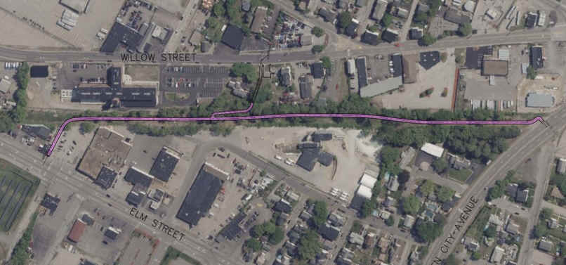
Note; A cross-light will take you over Queen City Ave, where future construction will continue the trail North, along the old rail bed. This section will be called the Central Manchester Rail Trail. It will bring you to Elm Street after 0.7 miles. See; Map Below. For more information visit; RAISE MANCHESTER .
Old Railroad Equipment:
+
RR Whistle Post:
The Whistle Post,
was a post with a large "W" engraved or painted on it. This
meant the railroad engineers were to start sounding the trains Whistle.
The Whistle posts
were usually placed 0.25 miles
in advance of a road crossing,
bridges, tunnels and other points. Usually, there would be a post placed on both
sides of the crossing, covering both directions.
HH
CLICK HERE FOR METHUEN RAIL TRAIL MAP
CLICK HERE FOR SALEM BIKE-PED CORRIDOR MAP
CLICK HERE FOR WINDHAM RAIL TRAIL MAP
CLICK HERE FOR DERRY LOOP TRAIL MAP
CLICK HERE FOR LONDONDERRY RAIL TRAIL MAP
CLICK HERE FOR SOUTH MANCHESTER RAIL TRAIL MAP
CLICK HERE FOR MANCHESTER TRAILS MAP
BEFORE YOU SET OUT BE SURE TO READ THE
WAIVER OF RESPONSIBILITY AND DISCLAIMER
BIKE IT OR HIKE IT