
FALL RIVER REGIONAL BIKEWAY:
Alfred J. Lima QUEQUECHAN RIVER RAIL TRAIL:
FALL RIVER HERITAGE STATE PARK WALKWAY:
DAVOL STREET BIKEWAY:
BOUTHOT MEMORIAL BIKE PATH:
SOMERSET-FALL RIVER-WESTPORT, MASSACHUSETTS
-BIKE IT OR HIKE IT-
Last Updated: May 05, 2026
Length: Fall River Heritage State Park Walkway; 1.5 miles
Davol Street Bikeway; West Side; 1.5 miles
Davol Street Bikeway; East Side; 1 mile
Bouthot Memorial Bike Path; 1.1 miles
Kennedy Park Loop; 1 mile Loop
Alfred J. Lima Quequechan River Rail Trail; 2.8 miles
Difficulty: Fall River Heritage State Park Walkway; Easy. Flat paved trail. Boardwalk section does not allow bikes.
Davol Street Bikeway East & West Sides; Easy. Flat, paved trail.
Bouthot Memorial Bike Path; Easy. Paved trail up and over the bridge.
Kennedy Park Loop; Easy. Flat paved trail.
Alfred J. Lima Quequechan River Rail Trail; Easy. Flat paved rail trail.
Directions:
To start from Battleship Cove & the Fall River Heritage State Park Walkway [Central Section]; From I-195 take exit 11 to the Western Fall River Expressway and head left (south). Enter Water St Connector and follow to Water St. Turn right and follow underneath I-195. This will bring you down to the Battleship Cove parking area on your left.
To start from the Martine Street parking lot & the Alfred J. Lima Quequechan River Rail Trail [Southeastern End]; From I-195 take exit 14A to Route 24 south. Take exit 2 to Brayton Ave and turn right. Turn right on Martine St (Route 6). Travel 0.4 miles to the Martine Street parking lot on your right next to LePage's Seafood.
The Fall River Regional Bikeway, once completed, will begin from Westport and travel West, alongside South Watuppa Pond via the Alfred J. Lima Quequechan River Rail Trail. It then turns Northwest, following the Quequechan River. A Gap exists to the next section at Battleship Cove, where the Fall River Heritage State Park Walkway & Davol Street Bike Trail both travel North, alongside the Taunton River, to Bicentennial Park, where another Gap exists North, to the Bouthot Memorial Bike Path. This trail takes you West, across the Taunton River via the Veterans Memorial Bridge to Somerset. Pvt. M Bouthot was killed in Iraq in 2006 and this trail is dedicated to him. From Battleship Cove, you can also connect, South, on-road, to the Kennedy Park Loop.
The Alfred J. Lima Quequechan River Rail Trail follows the rail bed of the Old Colony Railroad. This former rail line terminated in Fall River in 1854. On April 9, 1861, the Old Colony was authorized to build and operate a railroad from the end of track in Fall River, to the Rhode Island state line, to connect with a railroad to be built from Newport. It was renamed the Old Colony & Newport Railway.
The Fall River Regional Bikeway is part of the larger SOUTH COAST BIKEWAY , a planned 50-mile continuous system of bike paths and BIKE LANES that will connect Rhode Island to Cape Cod. Cities and towns included in this plan are Swansea, Somerset, Fall River, Westport, Dartmouth, New Bedford, Fairhaven, Mattapoisett, Marion, Wareham and Bourne. Several segments of the bikeway already exist in Swansea, Fall River, New Bedford, Fairhaven and Mattapoisett.
FALL RIVER REGIONAL BIKEWAY:
Fall River Heritage State Park Walkway:
Starting from the Battleship Cove parking lot [Southern End]; The Carousel Building, restrooms and food are all located here, as well as, access to BATTLESHIP COVE . From the parking lot head North, across the *Pedestrian Bridge over the mouth of the Quequechan River to FALL RIVER HERITAGE SP .
Note; The Fall River Heritage State Park Walkway boardwalk travels alongside the Taunton River and restricts the use of bikes, so if you are biking head right to utilize the Davol Street Bike Trail. See; Below.
Continue left, following the boardwalk alongside the Taunton River and past the Fall River heritage SP Visitor Center. Pass by the Heritage State Park Boathouse parking area, where the boardwalk now parallels the Davol Street Bike Trail. Pass by a Marina and a wooden dock jutting out into the Taunton River, before coming to the Senator Thomas Norton City Pier at 0.5 miles. Here, a wide, cement trail Loops around the pier and back to Davol St. Here, the trail continues alongside the river, utilizing various surfaces, bringing you to Bicentennial Park, where you'll find Veteran Memorials and restrooms. The paved trail ends as you come to three stone-dust paths. Bear left and follow this path across a boat launch, past a parking lot to Brownell St after 1.5 miles. The trail currently ends here as of 2026.
Davol Street Bike Trail; West Side:
From the *Pedestrian Bridge head right, up the ramp to a cement trail, then past the Fall River Heritage SP Visitor Center and out to Davol St. Here the wide, paved Davol Street Bike Trail [Southern End] heads North, alongside Southbound Davol St. Pass by the Heritage State Park Boathouse parking lot, where the Fall River Heritage State Park Walkway boardwalk parallels along your left. Pass a **Wooden Dock jutting out into the Taunton River at 0.5 miles.
Note; Here, you can connect to the Start of the Davol Street Bike Trail; East Side, via the wide, paved East-West Tunnel Connector on your right, which travels through a tunnel under the road. See; Below.
A wide median is along your right. Pass by the Senator Thomas Norton City Pier and come to Turner St. You'll lose the Fall River Heritage State Park Walkway past here, as well as, views of the river.
Note; Here, the wide paved Turner Street Trail connects East, to the Davol Street Bike Trail; East Side.
The trail continues alongside Davol St, with several more connections to the Davol Street Bike Trail; East Side via the President Ave Trail & Cory Street Trail, before finally coming to the Brightman Street Trail. You'll need to head right, East, along this trail which connects to the Davol Street Bike Trail; West & East Side ***Intersection & start of the Bouthot Memorial Bike Path after 1.5 miles. See; Below.
Note; The Davol Street Bike Trail; East Side travels South. See; Below.
Bouthot Memorial Bike Path:
From the Davol Street Bike Trail; West & East Side ***Intersection [Northern End]; [Continuing Mileage] The wide, paved Bouthot Memorial Bike Path travels North, underneath, then up to the Veterans Memorial Bridge. A separated cement path takes you up and over the bridge to Riverside Ave in Somerset. A couple of promenades along the bridge overlooking the Taunton River. Warning; Drawbridge, may be delayed.
Note; Right, the wide, paved Riverside Ave Path travels South, to Shades Ferry Blvd after only 0.25 miles. Across Riverside Ave is Slade's Ferry Park, where you'll find lots of picnic tables, along with parking.
Cross Riverside Ave and come to a median.
Note; Right, North, leads to Newhill Ave and ends. Future plans will continue trails alongside the Taunton River, via the proposed Taunton River Bike Path & Somerset Riverwalk.
The wide, paved trail continues East, below Route 6 through Chick Marchand Memorial Park. Come to Brayton Ave after 1.1 miles and the end of the trail.
Note; Right, North, will quickly bring you to the Brayton Ave BIKE LANE, which travels 0.5 miles to Read St. Head left, West and the Read Street BIKE LANE will bring you to the South Complex after 0.9 miles. Playground, ball fields and parking lot.
Davol Street Bike Trail; East Side:
Starting from the Davol Street Bike Trail; West Side, next to the **Wooden Dock; Head East, along the wide, paved East-West Tunnel Connector, which travels through a tunnel underneath the road. The wide, paved Davol Street Bike Trail; West Side then heads North, alongside Northbound Davol St. Wide median along your left. Come to Turner St.
Note; Here, the wide paved Turner Street Trail connects West, to the Davol Street Bike Trail; West Side.
The trail continues alongside Davol St, with several more connections to the Davol Street Bike Trail; West Side via the President Ave Trail & Cory Street Trail, before finally coming to the Brightman Street Trail after 1 mile. The Davol Street Bike Trail; West Side heads left, West, along the Brightman Street Trail, while the wide, paved Bouthot Memorial Bike Path travels North. See; Above.
Kennedy Park Loop:
Starting from the Battleship Cove parking lot; The Carousel Building, restrooms and food are all located here, as well as, access to BATTLESHIP COVE .
Note; You can also park at Kennedy Park. The on-road route includes some hills.
To access the Kennedy Park Loop follow the paved trail past the Carousel Building and Battleship Cove out to Water St. Head right, South, on-road, (BIKE SHARROWS) along Water St. Spot the old train cars on your left, before passing by the NARROWS CENTER for the ARTS , MARITIME MUSEUM and finally the Gates of Ponta Delgada. The city of Ponta Delgada, located in Azores, had gifted to Fall River these beautiful gates, replicas of the gates that welcomes visitors to that city. Head up a slight ramp along Ponta Delgada Blvd to Ferry St. Bear left crossing over the RR tracks.
Note; Looking West, these RR tracks quickly end. Future plans call for constructing the 2.8 mile Mount Hope Bay Greenway along the old rail bed South, to Tiverton.
This brings you to Columbia St after 0.5 miles. Continue straight along Eagle St for a 0.2 mile long uphill climb to Bradford Ave. Kennedy Park is across the road, however, you'll need to head right to access a cross-walk at Broadway. Cross over Bradford Ave and ***Broadway to start the Kennedy Park Loop after 0.7 miles. *Broadway separates the park into Western & Eastern Sections.
Heading West through the Western Section of the park, the paved Kennedy Park Loop follows the Northern Side of the park. Pass by a parking lot and fountain before coming to a stone pavilion that overlooks the mouth of the Taunton River, across which you can spot the old cooling towers on Brayton Point. Head East, back along the Southern Side of the park past a playground then up to Middle St. Cross ***Broadway to the Eastern Section of the park, where the trail parallels Middle St, with sports fields along your left. Come to S Main St and head left. Beautiful granite church across the street. Come to Bradford Ave and head left, West, back to Broadway along the Northern Side of the park, completing your Loop after 1 mile. Cross Bradford Ave and return to Eagle St, retracing your route back to the Battleship Cove parking lot after 2.5 miles.
Alfred J. Lima Quequechan River Rail Trail:
Starting from the Martine Street parking lot [Eastern End]; From the parking area head down to the Alfred J. Lima Quequechan River Rail Trail. This trail follows a former rail bed.
Note; Heading East, the trail quickly comes to an end at the Westport town line, after only 0.1 miles. The trail will be extended East, another 0.25 miles, to Route 6 in the future.
Heading West, the paved trail follows along the Northern shore of South Watuppa Pond. Pass by a small shaded picnic area on your left that juts out into the pond. After only 0.6 miles, a cross-light takes you over Brayton Ave to a Map Board. The trail now travels Northwest, through a marsh and across a wooden bridge. Look right to spot an old stone mill building. Travel underneath Route 24, followed by another bridge and another tunnel underneath I-195. Here you'll pick up the Quequechan River. Come to ****Quequechan Street at 1.2 miles.
Note; Heading right, Northeast, on-road (sidewalk available) across a bridge over the Quequechan River, brings you to the paved Alfred J. Lima Quequechan River Rail Trail on your right.
Note; Future construction will continue the trail left, North, alongside the Quequechan River, connecting to the completed trail in Interchange Park.
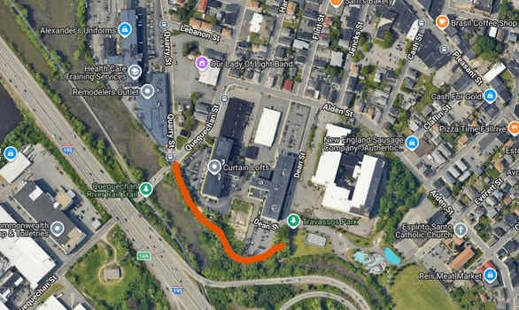
The wide, paved Alfred J. Lima Quequechan River Rail Trail takes you Southeast, alongside the river to Travassos Park, next to old stone mills and a parking lot. Pass an outdoor roller rink & playground. The trail then Loops around a sports field before traveling between the playground and a splash park, returning you to the parking lot after 0.5 miles. See; Map Below.
Continuing straight, where a boardwalk leads to the paved trail along a causeway. Cross another bridge at 1.5 miles before coming to another informational board, benches, some RR tracks and an old RR Switch. + See; RR Switch Below. The trail splits at 1.8 miles.
Note; Heading left, West, across a bridge takes you underneath I-195 and out 0.2 miles to Rodman St.
Continuing straight across another bridge the trail veers off the old rail bed bringing you around to Britland Park at 1.9 miles.
Note; Straight the trail leads to the Britland Park parking lot.
Note; Future plans will continue the trail Northwest, to connect to the Heritage State Park Walkway.
Heading right, Southeast, the trail now Loops back between the park and river, passing by Interchange Park before the trail currently ends after 2.2 miles.
Note; Future plans call for continuing the trail Southeast, along the river, back to ****Quequechan Street, where it will re-join the Alfred J. Lima Quequechan River Rail Trail.
Old Railroad Equipment:
+ RR Switch:
A RR Switch is a mechanical
installation enabling trains to be guided from one track to another, such as at
a junction or where a spur or siding branches off.
HH
FALL RIVER REGIONAL BIKEWAY MAP
BEFORE YOU SET OUT BE SURE TO READ THE
WAIVER OF RESPONSIBILITY AND DISCLAIMER
BIKE IT OR HIKE IT