EASTERN TRAIL:
PORTLAND-KENNEBUNK, MAINE
-BIKE IT OR HIKE IT-
Last Updated: February 25, 2025
Length: Eastern Trail [Northern Section]; 5.4 miles
Eastern Trail [North Central Section]; 8.3 miles [3.8 mile Gap between Northern & Central Sections]
Eastern Trail [South Central Section]; 6.1 miles
Difficulty: Easy. Flat, paved & crushed gravel rail trail.
Directions:
To Start from Bug Light Park in South Portland [Northern Section/Northern End]; From the junction of Route 77 (Casco Bay Bridge) and Broadway in South Portland follow Broadway east all the way to Breakwater Dr and turn left. Turn right on Madison St and follow to Bug Light Park. The first parking lot is for the boat launch, continue right to the car parking lot.
To Start from the Eastern Road parking lot in Scarborough [North Central Section/Northern End]; From the junction of Routes 1 & 207 in Scarborough, follow Route 207 south quickly to Eastern Rd. Turn right and travel 0.3 miles to the parking lot on your left.
To start from W Cole Road in Biddeford [South Central Section/Northern End]; From I-95 take exit 32 to the Biddeford Connector, then turn right on Route 111. Take your 2nd right on W Cole Rd. You can part at the Southern Maine Medical Center Rear parking lot, on your right, just before the road ends. The trail starts at the end of the road.
To Start from Kennebunk Elementary School parking lot in Kennebunk [South Central Section/Southern End]; From I-95 take exit 25. Northbound; Turn left on Route 35 and travel 1 mile to the school on your right. The trail connector is located at the south end of the parking lot.
See; EASTERN TRAIL PARKING for more parking locations.
The Eastern Trail is a proposed 65 mile trail running Southwest, from Bug Light Park (where Liberty Ships were constructed during WWII) in South Portland to Kittery. The trail follows the rail bed of the former Eastern Railroad, which was the first railroad to connect Boston to Portland, operating from 1842 until 1945. In 1872 the Eastern Railroad bought out the Portland, Saco & Portsmouth RR. The trail, as of 2025, is comprised of 3 Sections: The Northern Section travels Southwest, from South Portland, with a Gap to the Scarborough section. The North Central Section travels Southwest, from Scarborough through Old Orchard Beach to Saco, with a Gap to the Biddeford section. The South Central Section travels Southwest, from Biddeford, through Arundel to Kennebunk. The 4th Southern Section is still under design and will extend the trail Southwest, to North Berwick. See; EASTERN TRAIL CONNECTIVITY STUDY . For more information visit; EASTERN TRAIL , GREENBELT WALKWAY & MAINE TRAIL FINDER .
The Eastern Trail is part of the EAST COAST GREENWAY , a planned biking & hiking route stretching 3,000 miles from Maine South, to Florida. When complete it will traverse 15 states with a mostly off-road path.
Eastern Trail:
Northern Section:
Starting from Bug Light Lighthouse [Northern End]; The paved Spring Point Shoreway Trail/Eastern Trail/Greenbelt Walkway all start from the Bug Light Lighthouse, which overlooks Portland Harbor and where the Fore River discharges into Casco Bay. Across the channel sits Fort Gorges on Hog Island Ledge. Picnic tables/benches. This section in South Portland is also known as the South Portland Greenbelt Walkway.
Note; A narrow, paved trail travels Southwest, down along the harbor, to the Bug Light Boat Ramp parking lot.
The wide, paved Spring Point Shoreway Trail travels Southeast, alongside the bay and past the Bug Light Park parking lot to the Liberty Ship Memorial (Liberty Ships were built here during World War II). Informational signs along the trail. Exit the park where the trail travels South, alongside Madison St. Come to *Breakwater Drive at 0.6 miles.
Note; Left, East, a narrow paved trail along Breakwater Drive brings you to the Spring Point Shoreway Trail .
Continue straight along the paved trail as it travels along open fields, turning Southwest. Pass a spur trail left out to Preble St before following a residential corridor with multiple street crossings. Pass by some old RR tracks before coming alongside a cove for Fore River at 1.4 miles. Cross Cottage Rd and follow Trout Brook before crossing it. Cross Ocean St and enter a commercial corridor before coming to Broadway & Route 77 at 2.2 miles.
Note; Right, North, the paved Casco Bay Bridge Path takes you over the Fore River to Portland, where you connect to the West Commercial Street Pathway, part of the Portland Peninsula Loop Trail. See; Portland Trails .
A series of cross lights gets you over Broadway to a Map Board, where the trail continues West, alongside another cove for Fore River. Come to Chestnut St at 2.8 miles and travel left, on-road (residential) to the end of Chestnut St, where you'll pick up the paved trail again on your right at 3 miles. This is as far as I traveled. The trail now travels South, alongside some RR tracks, crossing Broadway again and following a residential corridor briefly before all woodlands at 3.9 miles. Pass by some solar panels in an open field before coming to Wainwright Sports Complex. Travel around the ball fields to Gary L Maietta Way at 5.4 miles and the current end of the trail. Wainwright Sports Complex parking lot here.
Note; As of 2025, a Gap exists between the next section Southwest to Scarborough. This 1.6 mile section is under construction, as of, 2026. Scheduled to open Fall 2027. See; Map Below.
CLICK HERE for an on-road route around this Gap.
North Central Section:
Starting from the Southern End of the future 1.6 mile "Close the Gap" section in Scarborough, after it crosses the Nonesuch River and comes to a transmission line; I haven't checked out this section. The Eastern Trail follows the old dirt railbed Southwest a short distance. Here, I believe the trail goes off the old railbed.
Note; Straight, the old railbed soon becomes Desfosses Ave.
This bypass travels left, through the woods, bypassing Desfosses Ave and bringing you back to the old railbed. Continuing left, Southwest, along the dirt railbed brings you to Eastern Ave after 0.8 miles. Continue on-road (Residential Eastern Ave is the old railbed) to Black Point Rd after 1.9 miles. Here you'll briefly, pick up a paved trail that travels alongside Eastern Rd. You then continue on-road, coming to the Eastern Road parking lot after 2.2 miles.
Starting from the Eastern Road parking lot in Scarborough [Northern End]; [Re-zeroing Mileage] I've checked out this section. The open, crushed gravel Eastern Trail continues Southwest, passing fields and marshlands of the Nonesuch River. Pass by the Willowdale Golf Club, before a causeway through Mill Brook, which brings you to a Spur Trail on your right at 0.9 miles, which leads to Washington Ave. You now follow a causeway through Scarborough Marsh, the largest saltwater marsh in Maine. Informational signs. A highlight of the trail. Cross a bridge, over the Nonesuch River, before passing by the Pine Point Road parking lot and crossing Pine Point Rd at 2.2 miles. Map Board. This was as far as I traveled. The crushed gravel & grass trail continues into the woods, crossing Old Blue Point Rd and into Old Orchard Beach, then Milliken Mills Rd at 3.8 miles. Cross a bridge over Mill River, before crossing Cascade Rd. Pass by a Spur Trail on your right at 5.2 miles, which leads to Mill Brook Rd, as you cross into Saco. The trail travels up to and over Portland Rd (route 1), before crossing Moody St at 6.7 miles. I've checked out this next section. The now paved trail, turns left, off the rail bed to Route 1. Here the paved trail follows alongside Route 1, traveling underneath I-195 and across the off-ramp to a Map Board, where at 7.2 miles, the crushed gravel trail turns right, back to the rail bed. You continue Southwest, alongside active RR tracks on your right, before the trail turns left off the rail bed again. Come to Thorton Academy Middle School, where the trail is paved again. You travel around some sports fields and out to Clark St in Saco after 8.3 miles and the current end of the trail.
Note; As of 2025, a 3.1 mile Gap exists Southwest, between the next section in Biddeford and is referred to as the "Over the River" section. Under study in 2025. See; Map Below.

CLICK HERE for an on-road route around this Gap.
Note; Between Saco & Biddeford you can check out the Biddeford-Saco Riverwalk .
South Central Section:
Starting from W Cole Road in Biddeford [Northern End]; [Re-zeroing Mileage] I haven't checked out this section. The crushed gravel Eastern Trail travels Southwest, into the woods. Isolated and straight as an arrow. Active RR tracks parallel the trail to your left. Travel underneath the Biddeford Connector at 0.5 miles. Cross a bridge over a brook, before crossing into Arundel and crossing another bridge over a creek. Cross Bass Lane at 1.7 miles. Cross Limerick Rd at 3.9 miles, where you'll find a Map Board. Possibly cross a couple more small bridges, before crossing a bridge over the Kennebunk River at 4.7 miles, into Kennebunk. Cross a bridge over I-95 at 5.6 miles. You'll pass by a Spur Trail on your right, which leads up to the Kennebunk Elementary School parking lot, before coming to Alewive Rd in Kennebunk after 6.1 miles and the current end of the trail.
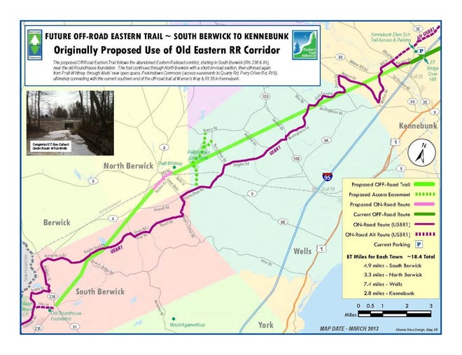
Note; As of 2025, the Southern Section, referred to as the "Blaze the Trail South", is under design, which will extend the Eastern Trail 11-miles, from Kennebunk, Southwest, to North Berwick. Construction funding for two end portions of this segment or 2.7 miles of trail total, have been awarded. This will create trail access immediately adjacent to the Kennebunk Savings Operations Center in West Kennebunk and Pratt and Whitney along Route 9 in North Berwick. Construction could start in 2025/26. See; Map Below.
Southern Section:
Eastern Trail Gap Map:

HH
CLICK HERE FOR EASTERN TRAIL MAP
BEFORE YOU SET OUT BE SURE TO READ THE
WAIVER OF RESPONSIBILITY AND DISCLAIMER
BIKE IT OR HIKE IT
