DRYDEN RAIL TRAIL:
JIM SCHUG TRAIL:
DRYDEN-FREEVILLE, NEW YORK
-BIKE IT OR HIKE IT-
Last Updated: November 24, 2024
Length: Jim Schug Trail; 4.1 miles
Dryden Rail Trail; 3.4 miles
Difficulty: Jim Schug Trail; Easy. Flat, hard packed cinder & grass rail trail.
Dryden Rail Trail; Easy. Flat, hard packed cinder & grass or stone-dust rail trail?
Directions:
To Start from E Lake Rd/Willow Crossing parking lot in Dryden for the Jim Schug Trail [Southern End]; From the junction of Route 13 & 38 in Dryden follow Route 38 south for 3.6 miles. Turn left on Purvis Rd, then right on E Lake St/Willow Crossing. The parking lot and trailhead will be on your left.
Starting from the Game Farm Road parking lot for the Dryden Rail Trail [Western End] & East Ithaca Recreation Way [Northeastern End]; From the junction of Routes 13, 34 & 79 in Ithaca travel east on Route 79 for a mile. Turn left on Route 366 (Mitchell St-Ithaca Rd-Dryden Rd) and follow for 2.1 miles. Turn right on Game Farm Rd and travel 0.7 miles to parking lot on your right.
The Dryden Rail Trail follows the former rail bed of the Lehigh Valley Railroad and will travel Northwest from Dryden to the village of Freeville, where it will then turn Southwest through the towns of Etna & Varna and connect to the East Ithaca Recreation Way in East Ithaca. The Eastern Section is complete from Dryden to the village of Freeville, while the Western Section is complete from East Ithaca to Varna. The Central Section has not yet been developed. In Dryden the Southern Section is called the Jim Schug Trail. For more information visit; JIM SCHUG TRAIL , DRYDEN RAIL TRAIL & FRIENDS of DRYDEN RAIL TRAIL .
Dryden Rail Trail; Eastern Section:
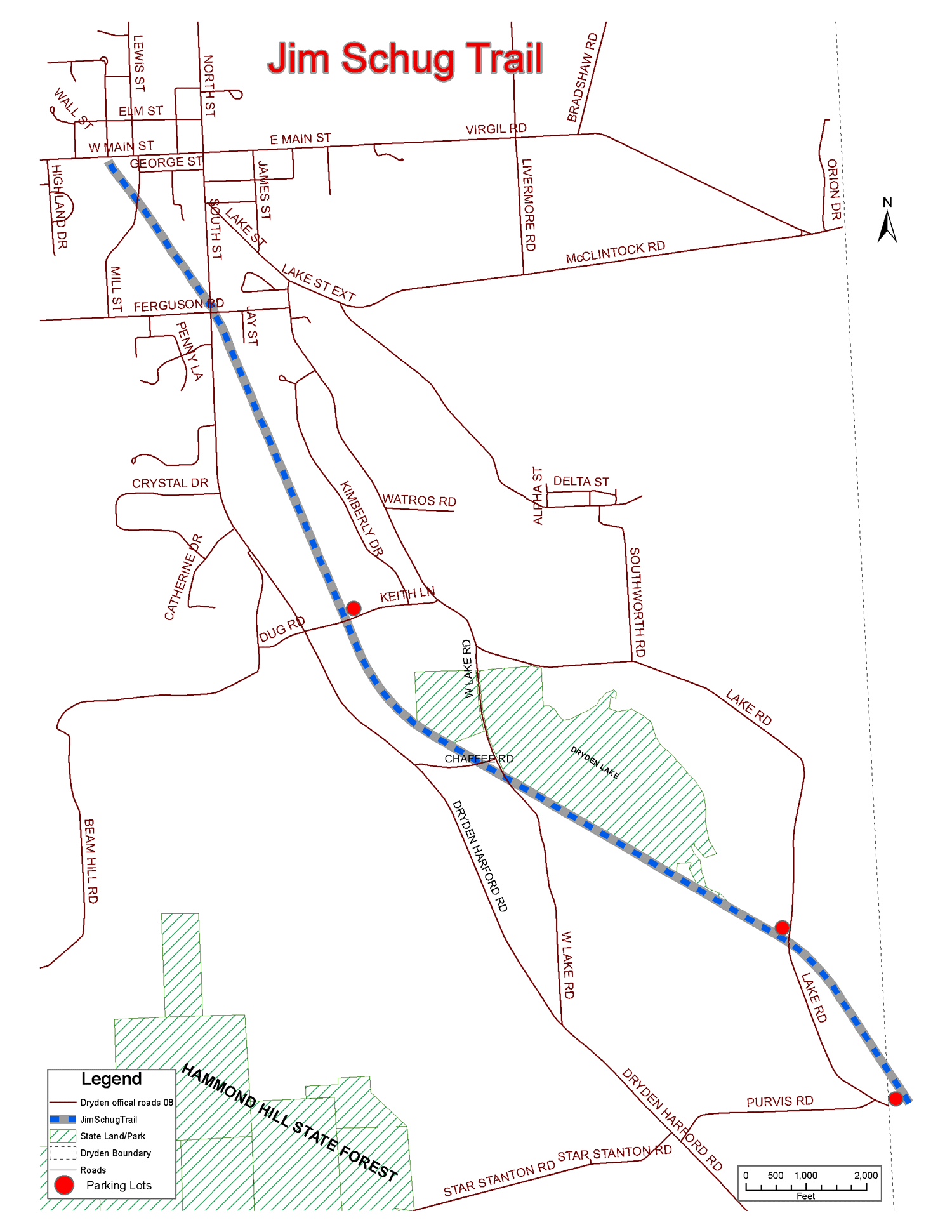
Starting from E Lake Rd/Willow Crossing parking lot in Dryden [Southern End]; Mile Markers every 0.5 miles along with a bench. The Jim Schug Trail consists of hard packed cinder & grass as it follows the old rail bed Northwest. Travel through a marsh along a causeway crossing a bridge before coming to the Lake Road parking lot at 0.7 miles. Travel through another marsh along a causeway before passing by Dryden Lake. Lots of wildlife sightings including Blue Herons. Come to an intersection at 1.5 miles.
Note; The trail on your right will bring you to Dryden Lake Park where you'll find rest rooms, fishing and picnic shelters.
Continue straight leaving the lake behind. Cross W Lake Rd before coming to Chaffee Road parking lot at 1.8 miles. Another marsh with 3 bridge crossings along the Dryden Lake Outlet that parallels the trail North before crossing Keith Lane parking lot at 2.4 miles. The trail travels along a partially shaded corridor passing by a pond and crossing Weber St at 3.5 miles where you'll find a Map Board. Quickly cross South St (Route 38) and the trail passes by the Dept of Public works before crossing Mill St at 3.9 miles. Cross an old iron RR bridge over Virgil Creek where the grass trail brings you out to Main St in downtown Dryden at 4.1 miles. Map Board located here.
I have not checked out this next section. The Dryden Rail Trail continues Northwest across Main St, as a hard packed cinder & grass rail trail. You quickly cross Elm St and leave the village behind following a wooded corridor. Cross Spring House Road, small parking lot, where the trail heads West crossing a bridge over Egypt Creek. Cross a causeway along Virgil Creek before crossing George Road and a parking lot at 5.7 miles. Map Board. The trail re-enters the woods back to the rail trail as it starts to turn North again. Come alongside Virgil Creek briefly. At 6.6 miles the trail follows DPW Dr. You'll come to a narrow stone-dust trail on your left. Follow this West, to Factory St in Freeville at 7 miles. Head left on-road (low traffic) then bear right on Union St and you'll quickly pick up the Dryden Rail Trail on your left. The trail travels South into the woods along a grass trail. Come to Freeville Depot Rd and continue on-road to Johnson Rd at 7.5 miles. Across the road a gate blocks the trail and says "No Trespassing".
Dryden Rail Trail; Western Section:
Starting from Game Farm Road parking lot in East Ithaca [Southern End];
Note; Heading West is the Eastern End of the East Ithaca Recreation Way in East Ithaca.
I have not checked out this next section. Heading Northeast through Varna, the stone-dust Dryden Rail Trail enters the woods and quickly crosses two bridges over Cascadilla Creek. Cross Stevenson Rd at 0.4 miles where the trail follows a dirt road briefly before re-joining the old rail bed at 0.8 miles. Travel past a large solar field before crossing Mt Pleasant Rd at 1.3 miles. Cross Route 366 via an old RR bridge followed by Monkey Run Rd at 2.1 miles. Finally you'll come to Route 13 after 2.8 miles.
Note; Construction is planned in 2025, to build a bridge over Route 13, where the trail will continue Northeast, to Pinckney Rd.
HH
CLICK HERE FOR JIM SCHUG TRAIL MAP
CLICK HERE FOR DRYDEN RAIL TRAIL MAP
BEFORE YOU SET OUT BE SURE TO READ THE
WAIVER OF RESPONSIBILITY AND DISCLAIMER
BIKE IT OR HIKE IT