
CHENEY RAIL TRAIL:
CENTER SPRINGS PARK LOOP TRAIL:
MANCHESTER, CONNECTICUT
-BIKE IT OR HIKE IT-
Last Updated: April 12, 2026
Length: Cheney Rail Trail; 1.7 miles
Center Springs Park Loop Trail; 1.3 miles
Difficulty: Cheney Rail Trail; Easy. Flat, stone-dust rail trail.
Center Springs Park Loop Trail; Easy. Paved trail with slight hills.
Directions:
To start from Truman Cowles Park for the Cheney Rail Trail [Northern End]; From I-84, take exit 63 to Route 30 east, then Route 83 (Oakland St-N Main St-Main St) south. Turn right onto Hilliard St. Truman Cowles Park, a small parking lot, will be immediately on your left.
To start from Center Springs Park for the Center Springs Park Loop Trail [Western End]; From I-84, take exit 63 to Route 30 east, then Route 83 (Oakland St-N Main St-Main St) south. Turn right on Bigelow St, left on Liberty St, right on Hemlock St then left on Lodge St.
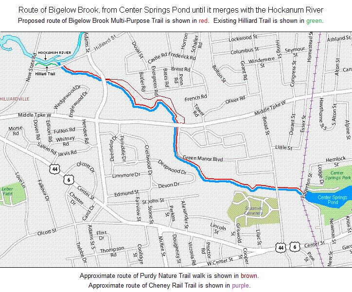
The Cheney Rail Trail follows the rail bed of the former South Manchester Railroad. The old South Manchester Railroad, as the Cheney's called it, connected Cheney Brothers silk mills to northern Manchester. Built in 1869 with Cheney family funds, the railroad linked the silk mills to the main line, at that time known as the “Providence, Hartford, and Fishkill Railroad,” which ran through the North End. At 2.25 miles, it was the shortest freight-and-passenger railroad in the United States, but the longest private railroad. Starting from Main St in Manchester, the trail travels South. For more information visit; CHENEY RAIL TRAIL . You can also access the Center Springs Park Loop Trail, near the Southern End of the Cheney Rail Trail. From the Southern End of the trail, you can also connect to the Charter Oak Greenway , via a short on-road route.
Cheney Rail Trail:
Starting from Main Street/RR crossing [Northern End]; Just South, of N Main St, across the RR tracks, the trail begins next to a RR Crossing sign.
Note; Construction is planned to begin in 2026 and will extend the trail Northeast, to the Hop River SP Trail in Manchester and consist of stone-dust. A pedestrian bridge will be built to cross Lydall Brook & about 10 parking spaces will be created on Old North Main St (behind the library). See; Map Below.
To connect on-road, (Not recommended for kids on bikes) head left, along Main St, crossing Route 83 to N School St (low traffic). Cross Route 83 and continue along Sheldon Rd, then head right on Colonial Rd and pick up the Hop River SP Trail on your left after 1.3 miles.
The wide, stone-dust Cheney Rail Trail travels South, passing a cement Whistle marker, before a cross-walk takes you over Hilliard St to the Truman Cowles Park parking lot after only 0.1 miles. The 0 MILE MARKER starts here. MILE MARKERS every 0.5 miles. From the parking lot, a picnic table, benches and Map Board are located in this tiny park. Very nice wayfinding signs along the route include a Map. This is an urban trail that travels through a residential and industrial corridor. Cross-walk over Woodland St at 0.3 miles where the trail continues to your right. The trail dips down past another old RR Crossing sign and brings you to Middle Turnpike at 0.8 miles where you'll find a Map Board and picnic table. The trail continues along the power lines. This section is a bit more isolated. You travel along a high berm and come to an iron arched bridge overlooking Center Springs Park & Pond below to your left at 1.2 miles.
Note; Just before the bridge, a side trail will bring you down to *Edgerton Street, where you may connect to the Center Springs Park Loop Trail. See Below.
Continuing across this arched bridge, you'll soon cross another old RR bridge over Center St. This section travels through the old rail yard which included a RR Roundhouse, + See; RR Roundhouse Below, now long gone, along with old RR tracks, sidings and an old RR Switch. + See; RR Switch Below. Here you'll find a picnic pavilion along with an informational board. On your right is a large stone wall and open area where an old RR building used to sit. Travel underneath Park St, which brings you to the old Cheney Mills (now Lofts at the Mills) after 1.7 miles. A wide sidewalk takes you past an old RR silk loading shed, followed by the old brick silk storage building with its iron doors and locks on your right.
Note; Be sure to check out the old Cheney Mills site, which is huge and contains beautiful old brick mill buildings.
Note; To connect to the Charter Oak Greenway from here you have 2 Options:
Option 1: Continue straight, South, on-road along Elm St (residential/sidewalk available). This will take you through the old Cheney Mills, passing the old Cheney Clock Tower on your left and Cheney Hall (now the Little Theatre of Manchester) on your right, before coming to Hartford Rd at 2 miles. Turn right, on-road (sidewalk available) and come to Pine St. Across Pine St is the Connecticut Firemen's Historical Society Museum (located in the old 1901 wooden fire house) and left, across Hartford Rd is a small pocked park with benches and an informational pavilion. This brings you to Prospect St. If you cross Prospect St you'll come to a small gauge RR track loop park. Nicely done. Travel down Prospect St and across I-384. Here you'll pick up the Charter Oak Greenway , which travels East-West, after 2.3 miles.
Option 2: Continue straight, South, on-road along Elm St (residential/sidewalk available). This will take you through the old Cheney Mills, passing the old Cheney Clock Tower on your left and Cheney Hall (now the Little Theatre of Manchester) on your right, before coming to Hartford Rd at 2 miles. Head left, along Hartford Rd (narrow shoulder/sidewalk available). Pass by the old 1751 Cheney Homestead and 1785 Schoolhouse on your right and the Great Lawn (Mansions of the Cheney management) on your left. Come to Main St, across which you'll pick up the Charter Oak Greenway at Charter Oak Park after 2.5 miles.
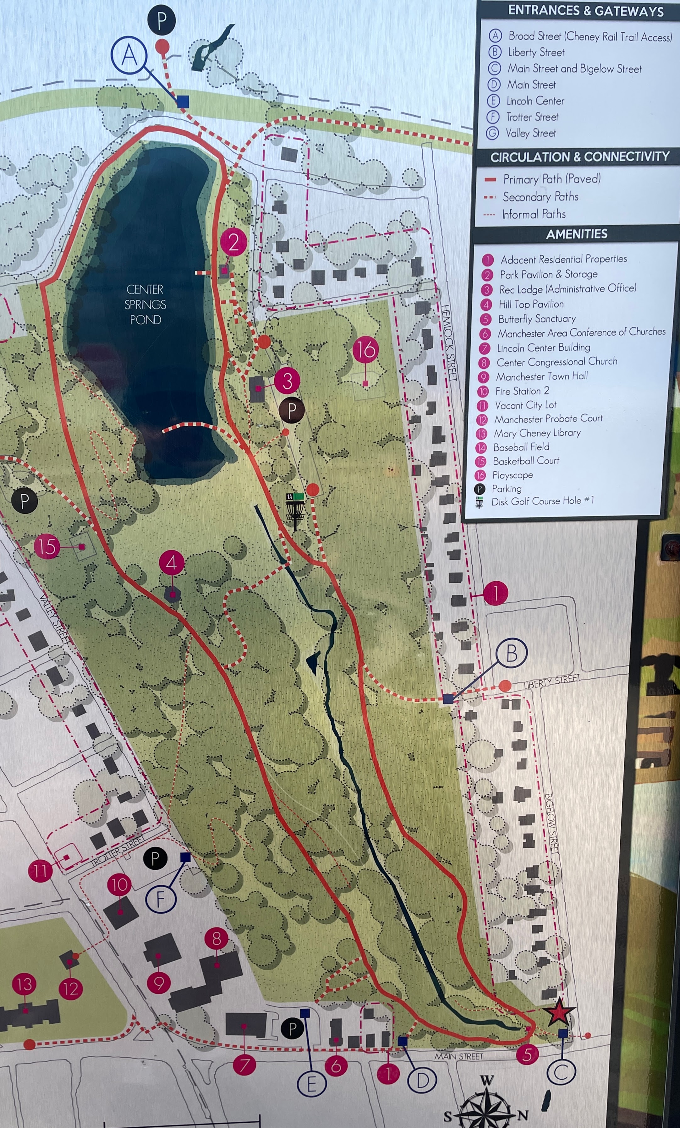
Center Springs Park Loop Trail:
Starting from the intersection of the Cheney Rail Trail & Center Springs Park [Western End]; From *Edgerton Street, a paved trail heads West, up to the Cheney Rail Trail.
Note; From Edgerton Street, another paved trail travels West, underneath the Cheney Rail Trail Bridge and out to Broad St. Here you'll find the Broad Street parking lot. Future plans call for creating a link to the planned Bigelow Brook Greenway, which will be built across Broad St on a vacant lot. No progress as of 2026. See; MAP .
From Edgerton Street, the narrow, paved Center Springs Park Loop Trail, travels East, along the Northern Side of Center Springs Pond. You'll pass by a pavilion, the Parks & Recreation building (restrooms available) on your left and some fishing docks on the right, before coming to an intersection. Head right up to Lodge Drive (closed to traffic) and turn right.
Note; Left brings you to the Center Springs Parks & Recreation parking lot. A Folf Course is located in the park as well.
Follow the road which turns into a wide paved trail straight ahead. The trail heads uphill following Bigelow Brook and then turns right, South, just below Main St (Route 83) at 0.6 miles.
Note; A short paved path takes you up to Main St and a small pocket park.
The trail now Loops back West, high above the brook, with a couple of spur trails on your left, leading up to Manchester town offices. Pass by a Spur Trail on your right at 0.9 miles.
Note; This narrow paved Spur Trail leads downhill to a small bridge over the brook, where you can return to Edgerton Street after a 1.3 mile Loop.
Continue straight and bare right at the next intersection. This takes you out to Edgerton St. Travel right, on-road (low traffic/sidewalk available), downhill, returning to Edgerton Street after a 1.3 mile Loop.
Old Railroad Equipment:
+ RR Roundhouse:
A RR Roundhouse is a building with
a circular or semicircular shape used for servicing and storing trains. They
could have only a few stalls or as many as 50. Locomotives would be serviced
with the front of the locomotive pointing outward and the tender of the
locomotive facing the Turntable. RR Turntables are bridges that
spin and are used for turning locomotives and rolling stock.
+ RR Switch:
A RR Switch is a mechanical
installation enabling trains to be guided from one track to another, such as at
a junction or where a spur or siding branches off.
HH
CLICK HERE FOR CHENEY RAIL TRAIL MAP
CLICK HERE FOR CENTER SPRINGS PARK LOOP MAP
CLICK HERE FOR HOP RIVER SP TRAIL & CHENEY RAIL TRAIL MAP
BEFORE YOU SET OUT BE SURE TO READ THE
WAIVER OF RESPONSIBILITY AND DISCLAIMER
BIKE IT OR HIKE IT