CAPITOL CRESCENT TRAIL:
WASHINGTON, DC-BETHESDA & SILVER SPRINGS, MARYLAND
-BIKE IT OR HIKE IT-
Letterbox Planted:
June 5, 2002Last Updated: November 02, 2025
Length: Capitol Crescent Trail; 7.1 miles
Difficulty: Easy. Paved rail trail with a downhill grade from Bethesda to Georgetown.
Moderate. Paved rail trail with an uphill grade from Georgetown to Bethesda.
Directions:
Starting from Georgetown [Southern End]; Wisconsin Ave runs from I-495 in the north, all the way to the Potomac River south in Georgetown. In Georgetown, Wisconsin Ave ends at Water & K Streets. Turn right (west) along Water St, which travels underneath the elevated Whitehurst Fwy. Metered parking along Water St. Georgetown Waterfront Park is on your left. The trail starts at the end of Water St where you travel through a tunnel underneath the Alexandria Aqueduct Ruins to the start of the Capitol Crescent Trail.
The trail officially begins from the Western End of Water St and the tunnel underneath the Alexandria Canal Potomac Aqueduct Ruins; Parking is available but requires a Fee. Instead you can park for at the Rock Creek Park; Thompson's Boat House parking lot and follow a paved trail for 0.9 miles to the trailhead. (Fee)
Starting from the Rock Creek Park; Thompson's Boat House parking lot in Georgetown [Southern End]; Wisconsin Ave runs from I-495 in the north, all the way to the Potomac River south in Georgetown. In Georgetown, Wisconsin Ave ends at Water & K Streets. Turn left (east) along K St, which travels underneath the elevated Whitehurst Fwy. When you see daylight (Freeway above turns) take a right towards Rock Creek Pkwy which heads south. Quickly come to an intersection where you'll turn right into the Thompson's Boat House parking lot (Fee).
To access the Trail via the Metro; Take the Red Line up to Bethesda Station. Take the elevator up to street level (bikes must use the elevators) and take a right down Montgomery Lane. Turn left on Woodmont Ave which will bring you to the junction of Bethesda Ave. Head left for the trailhead. Its only a little over a ¼ mile from the Metro to the trail. For other Metro information visit; BIKES on METRO .
The Capitol Crescent Trail runs along the route of the old Georgetown Spur, a B&O Railroad Line completed in 1910, from Georgetown to Silver Spring. Service was discontinued in 1985. The trail travels Northwest, from Georgetown, in Washington, DC, where it runs parallel to the Potomac River and Chesapeake & Ohio Canal , then curves North, inland to Bethesda. If you want to do this trail without any hills, you can start up in Bethesda and travel South, to Georgetown. Then simply take the metro, along with your bike, back to Bethesda. For more information check out; CAPITOL CRESCENT TRAIL , CAPITOL CRESCENT TRAIL; MONTGOMERY , CAPITOL TRAILS COALITION , DC TRAILS , BIKE WASHINGTON , WASHINGTON BIKE ASSOC .
Note; The National Park Service plans to rehabilitate 3.7 miles of the Capital Crescent Trail located between the Maryland/DC line and the Water St, DC, trailhead at the Alexandria Canal Potomac Aqueduct. The project consists of resurfacing the 10-foot wide asphalt pavement surface and reestablishing the 2-foot wide stone dust shoulders. Construction is planned for 2026.
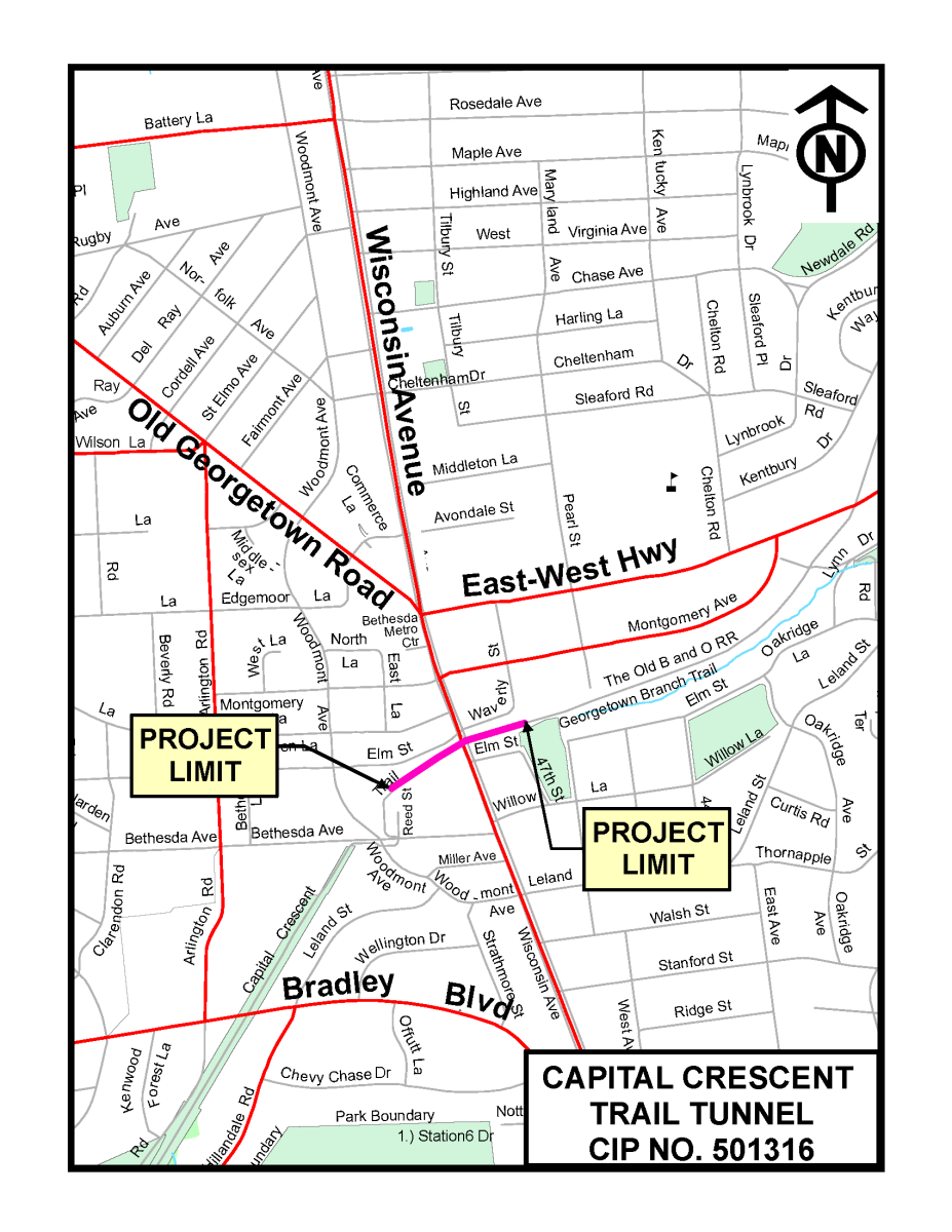
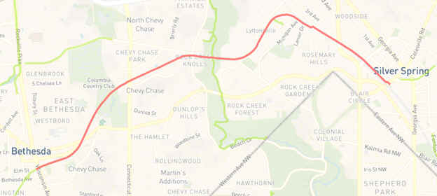
Note; In Bethesda, the trail used to travel through the Wisconsin Ave Tunnel, where it connected to the old Georgetown Branch Trail, which traveled Northeast, to Silver Spring. However, the old converted rail bed between Bethesda & downtown Silver Spring is currently returning to a transit line, the "Purple Line". A new paved trail is being installed alongside this new transit line and will become an extension of the Capitol Crescent Trail. Completion is expected in Fall 2026. See; PURPLE LINE/CCT EXTENSION .
Starting from the Rock Creek Park; Thompson's Boat House parking lot in Georgetown, Washington, DC; Head out of the parking lot to the Rock Creek Park Trail and travel left, North. You quickly come to an intersection underneath an off-ramp.
Note; Rock Creek Park Trail continues right, North.
Head left, West, along the narrow paved trail, underneath the Whitehurst Fwy. Come to 30th St NW. You have 2 Options from here:
Option 1: Direct Route: On your right is the K & Water Streets TWO-WAY SEPARATED BIKE LANE. Head left, West, along this BIKE LANE, which travels underneath the Whitehurst Fwy. You'll find bike rentals along this route. See; CAPITOL BIKESHARE . Travel through a tunnel underneath the Alexandria Canal Potomac Aqueduct Ruins to the start of the paved Capitol Crescent Trail after 0.9 miles.
Option 2: Scenic Route: On your right is the K Street TWO-WAY SEPARATED BIKE LANE. Head left, West, along this BIKE LANE, which travels underneath the Whitehurst Fwy. Come to 31st ST NW, where you'll pick up a paved trail. Turn left into Georgetown Waterfront Park. I haven't checked this out yet. You'll find bike rentals along this route. See; CAPITOL BIKESHARE . Follow the wide pavers South, to an overlook of the Potomac River. Then head right, West, through the park alongside the river. Pass by the Senator Charles Percy Plaza, which has a Splash Park. Pass by the Labyrinth before the trail turns back to Water St at 0.8 miles. Head left, West, along the Water Street TWO-WAY SEPARATED BIKE LANE. Next, travel through a tunnel underneath the Alexandria Canal Potomac Aqueduct Ruins to the start of the paved Capitol Crescent Trail after 1 mile.
Starting from the Western End of Water Street in Georgetown, Washington, DC [Southern End]; [Re-zeroing Mileage] The Capitol Crescent Trail starts after you travel through a tunnel underneath the Alexandria Canal Potomac Aqueduct Ruins to the paved trail.
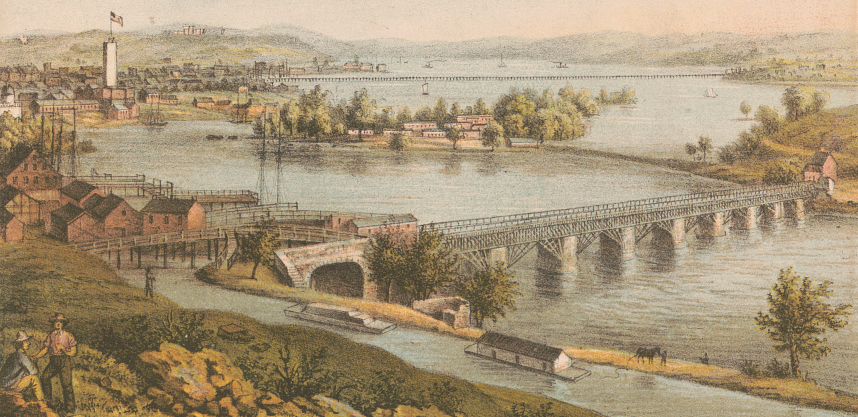
Note; There is a set of stairs on your right before you enter the tunnel that lead up to the Alexandria Canal Potomac Aqueduct Ruins. The Alexandria Canal connected the city of Alexandria, VA to Georgetown in Washington, DC. The Canal ran Southwards, for seven miles through today's Arlington County and City of Alexandria, Virginia, dropping 38 feet through a series of four Locks between Washington St and the Potomac River in the Northern portion of Alexandria. The Canal ended at a Tidal Basin (Pool No. 1 and a Tidal Lock (Lift Lock No. 1) located at the Northern End of Old Town Alexandria. Built between 1833 and 1843, the Potomac Aqueduct Bridge was designed to connect the Chesapeake and Ohio Canal to the Alexandria Canal. From 1843 to 1886, coal boats navigated across the Potomac Aqueduct, actually over the Potomac River, on their way via the Alexandria Canal. Later, the aqueduct became part of a trolley line from Rosslyn to Georgetown. If you look across the river, you can still see the only remaining pier. See; C&O Canal & POTOMAC AQUEDUCT RUINS .
You'll quickly pass by a Map Board across from the Washington Canoe Club as the trail follows alongside the Potomac River on your left and the Chesapeake & Ohio Canal up along your right. After 0.5 miles you'll pass by a Spur Trail on your right.
Note; To your right stairs lead up to the C&O Canal Towpath and to your left is the stone arched entrance to the Foundry Branch Tunnel. This 252-foot-long tunnel takes you underneath the C&O Canal and Canal Rd to a sidewalk along the North Side of Canal Rd. It started out as a culvert, then a road and now a trail. If you head right a short distance and look right you'll spot the old 1896 Foundry Branch Trolley Trestle, which once carried commuters from Georgetown through Dalecarlia and on to Glen Echo, once home to a popular amusement park along the old Washington & Great Falls Electric Railway Company. Plans are in the works to demolish this old trestle.
The trail turns Northwest and you'll pass by another spur up to the C&O Canal Towpath at 1.2 miles. Here the trail starts to pull away from the river. Pass by a large parking lot on your left, for Fletchers Cove, before coming to Fletcher’s Boathouse at 2.2 miles. Here, you can rent bikes, canoes or boats, get refreshments or use the restroom. Map Board located across the C&O Canal. At 2.7 miles you'll approach an old RR Trestle. Spot a dirt trail on your left that leads down to the C&O Canal. For the Letterbox, take this trail part way down, but do not cross under the bridge. Instead, turn left at the bottom of the stairs and spot two trees growing from one, just off the path. In the hollow base, under a rock and board is the Capitol Crescent Trail Letterbox. Cross the bridge over the C&O Canal and Canal Rd. Here the trail follows a ridgeline heading uphill. Pass by the Washington Aqueduct facility and cross into Montgomery County, MD at 3.7 miles. The Washington Aqueduct provides the public water supply system serving Washington, D.C., and parts of its suburbs, using water from the Potomac River. One of the first major aqueduct projects in the US, the Aqueduct was commissioned by Congress in 1852, and construction began in 1853. Next cross over a bridge and pass by a Map Board and water fountain and you'll soon travel through the Dalecarlia Tunnel, underneath Macarthur Blvd at 4.2 miles. The Dalecarlia Tunnel, a Roman Arch brick tunnel, is 18 feet wide by 340 feet long, built in 1910. As you go through the tunnel you’ll see "step backs", recessed areas that allowed people to avoid being hit by a train if they were caught in the tunnel. You then cross a bridge over Little Falls Branch which overlooks the Dalecarlia Reservoir. Enter a heavily wooded section as the trail turns Northeast. You then cross a bridge over the Little Falls Stream Valley Trail before passing by Spur Trail on your right.
Note; This trail leads to the Little Falls Stream Valley Trail.
Just before a bridge over Mass Ave pass by a Spur Trail on your right.
Note; This Spur Trail brings you down to Mass Ave and the start of the Little Falls Stream Valley Trail which follows the Little Falls Branch from Massachusetts Ave down through the East Side of Westmoreland Park to MacArthur Blvd, paralleling the Capitol Crescent Trail.
Cross Mass Ave at 5.3 miles and the trail soon follows an urban corridor as you enter Bethesda. Cross a long bridge over River Rd followed by a crosswalk over Dorset Ave and busy Little Falls Pkwy at 6.5 miles. Cross a bridge over Bradley Blvd before coming to Bethesda Ave. Lots of places to eat. Here you'll find the Bethesda Bikeway [SEPARATED BIKE LANE] heading right, East, along Bethesda Ave to Woodmont Ave where you cross over Bethesda Ave after 7.1 miles. Location of the Wisconsin Ave Tunnel.
Note; The Georgetown Branch Trail used to start here, where it entered the Wisconsin Ave Tunnel and traveled East, to Silver Springs. The Purple Line transit project has taken over the tunnel and old Georgetown Branch rail bed. The new Purple Line is being built along the old rail bed, along with an extension of the Capitol Crescent Trail, which will parallel it. They will both travel East, to the Silver Spring Transit Center in Silver Springs. Completion is expected in Fall 2026. See; Maps Below.
Bethesda Bikeway:
The Bethesda Bikeway SEPARATED BIKE LANE continues East, along Bethesda Ave, crossing Wisconsin Ave and continuing along Willow Lane to 47th St. Left paved paths take you North, through Elm Street Park. At the Northern End of this park is where the Georgetown Branch Trail used to exit the Wisconsin Ave Tunnel and continue East. For more BIKE LANES, check out; MONTGOMERY COUNTY BIKEWAYS .
HH
CLICK HERE FOR CCT MONTGOMERY COUNTY MAP
CLICK HERE FOR CAPITOL TRAIL NETWORK MAP
CLICK HERE FOR DISTRICT of COLUMBIA TRAILS MAP
CLICK HERE FOR MONTGOMERY COUNTY TRAILS MAP
LETTERBOX LAST VERIFIED ON
FEBRUARY 23, 2013
TO EMAIL A VERIFICATION
bikeitorhikeitcontact@gmail.com
BEFORE YOU SET OUT BE SURE TO READ THE
WAIVER OF RESPONSIBILITY AND DISCLAIMER
BIKE IT OR HIKE IT