CAPE COD RAIL TRAIL:
CAPE COD, MASSACHUSETTS
OLD COLONY RAIL TRAIL:
CHATHAM-HARWICH, MASSACHUSETTS
-BIKE IT OR HIKE IT-
Last Updated: May 05, 2026
Length: Cape Cod Rail Trail; 28.6 miles
Cape Cod Rail Trail [Sandwich Section]; 4 miles
Higgins Crowell Road Path [West Yarmouth]; 1.5 miles
Difficulty: Cape Cod Rail Trail; Easy. Flat paved rail trail.
Cape Cod Rail Trail [Sandwich]; Paved trail with slight hills.
Higgins Crowell Road Path [West Yarmouth]; Easy. Flat paved trail.
Directions: Cape Cod Rail Trail:
To start from Old Town House Road/Peter Homer Park in Yarmouth [Western End]; From Route 6 take exit 8 to Station Ave south. Just after you travel underneath the trail bridge the Station Ave parking lot will be on your left. Continuing south on Station Ave take your next right on Old Town House Rd. Travel 0.5 miles and the park entrance is on your right.
To Start from the Route 134 parking lot in Dennis [Mile 5.8]; From Route 6 take exit 9A to Route 134 south. The parking lot is located on the left just past Theophilis Smith Rd.
To Start from the Nickerson SP parking lot in Brewster [Mile 16.5]; From Route 6 take exit 12 to Rout2 6A and head left. Travel 1.6 miles to the Park's entrance on your left. Use the parking lot immediately to the right of the gate house. Daily fee, however, you can continue past the Park and take your first left into Barbs Bike Shop parking lot where parking is free.
To Start from the Lecount Hollow Road parking lot in Wellfleet [Northern End]; From the traffic circle in Orleans where the expressway ends continue 8.8 miles north on Route 6 to Lecount Hollow Rd. Turn right and the parking lot will be on your right.
Before the first railroad tracks were laid, the Cape was a relatively isolated area, accessible only by packet boat or stagecoach. By 1848, the Old Colony Railroad Company laid tracks that connected Boston and Sandwich. Railroad track extensions continued and by 1873, Old Colony had linked Boston with Cape Cod’s outermost point of Provincetown. The Cape Cod Rail Trail follows this former railroad right-of-way from Yarmouth, East through Dennis & Harwich to the Bike Rotary. Here, a spur East, to Chatham, along the Old Colony Railroad bed, is now the Old Colony Rail Trail. The Cape Cod Rail Trail continues North, through Brewster, Orleans, Eastham and Wellfleet. You can also access the Nickerson State Park Trails in Brewster & Nauset Bike Trail in Eastham from the Cape Cod Rail Trail. See; Cape Cod National Seashore Trails .
A paved, East-West section of the Cape Cod Rail Trail in Sandwich, travels alongside the Route 6 Service Rd, which parallels Route 6. Another East-West section of the Cape Cod Rail Trail will be constructed in Barnstable. For more information visit; CAPE COD RAIL TRAIL .
Cape Cod Rail Trail:
West to East to North:
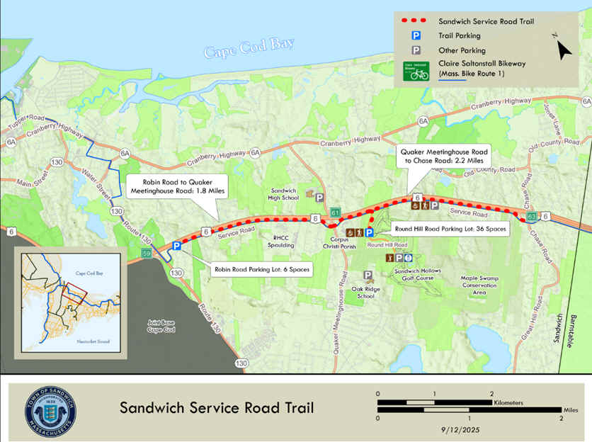
Starting from the Service Road parking lot (across from Robin Rd) in Sandwich [Western End]; The wide, paved Cape Cod Rail Trail travels East, alongside the Service Rd and above Route 6 below left.
Note; West, the Service Rd takes you down to Route 130. Not sure of future plans.
This trail has some slight hills. Cross Quaker Meetinghouse Rd at 1.8 miles. Pass Round Hill Rd at 2.2 miles on your right.
Note; The wide, paved Round Hill Road Trail takes you up a long incline, then down to the Round Hill Road parking lot after 0.2 miles.
The trail continues, ending after 4 miles at Chase Rd, near the Sandwich-Barnstable town line. See; Map Below.
In Barnstable, Phase 4 is in the design phase, as of 2026 and will extend the Cape Cod Rail Trail about 10 miles East, from the Sandwich town line to Mary Dunn Road. See; Map Below.
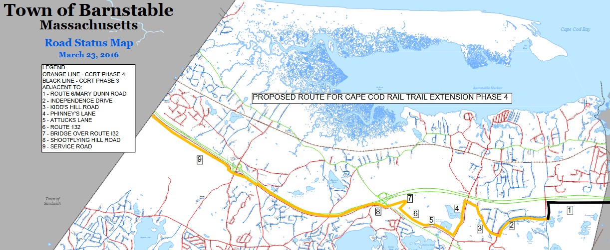
In Barnstable, Phase 3 is under construction, as of 2026 and will extend the Cape Cod Rail Trail from Mary Dunn Road East, 4 miles to the completed trail in West Yarmouth. A bridge is under construction that will take the trail over RR tracks and Willow St. Two new parking lots are also being built. One at Mary Dunn Rd and another off Higgins Crowell Rd. See; Map Below.
Starting from Higgins Crowell Road (Green Line on Map Above) in Yarmouth [Western End];
Note; The wide, paved Higgins Crowell Road Path travels North, alongside Higgins Crowell Rd, before abruptly ending just shy of the traffic circle (Red Line & P on Map Above) after 0.3 miles (this is where a new parking lot is under construction in 2026) It also travels South, alongside Higgins Crowell Rd, before ending at Buck Island Rd after 1.2 miles. [1.5 miles Total]
The paved Cape Cod Rail Trail winds East and rolls through the Pine/Oak forest. The trail here is older, thus not as wide as the rest of the trail. Just before the Bayberry Hills Golf Course at 0.4 miles spot a dirt path on your left.
Note; Phase 3 construction is underway in 2026 and will extend the trail North, to Higgins Crowell Rd and a new parking lot. In May 2026, they were repaving the trail East, to Peter Homer Park.
The trail now travels between the golf course bringing you out to Old Town House Road at 1.2 miles. Parking lot located here. Cross W Yarmouth Rd where the trail parallels Old Town House Rd. Cross Forest Rd and come to the Old Town House Road/Peter Homer Park parking lot after 1.9 miles. Restrooms, playground and sports fields located here. Yarmouth has granite Mile Markers every mile and granite 0.5 Mile Markers embedded in the trail. The trail then travels around the park, exiting alongside some RR tracks through an industrial/commercial corridor. A bridge takes you over Station Ave at 2.5 miles where you'll pass by the Station Ave parking lot. Map Board and benches here. Open wooded corridor. Cross Dupont Ave at 3.4 miles before coming to N Main St at 3.9 miles. Here the trail travels just South of Route 6, bringing you to the Bass River at 4.6 miles. A bridge takes you across the river into South Dennis, where the trail travels next to the Indian Lands Conservation Area along your right in Dennis. Pass by the Dennis Trailhead parking lot (Map Board and picnic tables) on your right before crossing Main St. A bridge takes you over Route 134 bringing you to the Route 134 parking lot at 5.8 miles. Map Board and picnic tables. Here you'll find the Dennis 0 Mile Marker. Granite Mile Markers every mile along the trail and include the town you are in. They are also painted on the trail every tenth of a mile. The trail heads continues East through a shaded tree corridor. Cross Great Western Rd at 6.5 miles and pass by a side trail to DENNIS CYCLE CENTER at 6.7 miles. Cross Depot St in Harwich at 7 miles where you'll find a small parking lot and Map Board. Look right to spot an old RR Whistle Post before traveling past some cranberry bogs. + See; RR Whistle Post Below. You cross the Herring River which leads into the West Reservoir on your right. Travel over the Great Western Rd again at 8 miles. Travel through a tunnel underneath Main St and you'll come to a Bike Rotary at 9 miles. A Map Board and benches are located in the middle of the rotary.
Note; The Cape Cod Rail Trail continues left, North, while the Old Colony Rail Trail, which travels out to Chatham, continues straight, East. See; Old Colony Rail Trail Below.
Continuing North along the Cape Cod Rail Trail look left to spot what I believe is an old cement RR Mileage Marker (no numbers). These old RR Mileage Markers were located every mile along the railroad. Pass by the trailhead for the HACKER WILDLIFE SANCTUARY at 9.8 miles. You then travel across Queen Ann Rd followed by a bridge over Route 6. You'll come to the Headwaters Drive parking lot at 10.4 miles. Picnic tables located here. Travel past Hinckley's Pond before crossing Pleasant Lake Ave and passing by Pleasant Lake General Store where you can grab a bite to eat at 11 miles. After crossing Squattom Rd you'll travel alongside Long Pond before crossing back over Pleasant Lake Ave and traveling alongside Seymour Pond. Porto-Potty and picnic tables are located here along the beach. Cross into Brewster at 11.8 miles before crossing Pleasant Lake Ave for the final time. Parking lot located here. After a long straightaway you'll come to the Long Pond Road parking lot just shy of 13.8 miles. Map Board and picnic tables. Busy road crossing. Pass by BREWSTER BIKE , before crossing Underpass Rd. Lots of places to grab a bite around here. At 15 miles will be a Spur Trail to Brewster Center. Head through a tunnel underneath Villages Dr and after several more road crossings you'll pass by a spur to BARBS BIKE SHOP and another parking lot before coming to a Spur Trail into Nickerson State Park at 16.5 miles. The Nickerson SP parking lot, restrooms, picnic tables and Map Board are all located here.
Note; You can check out the paved Nickerson State Park Trails South from here.
The trail continues North through a tunnel underneath Route 6A. After crossing Seaview Rd you'll travel past Namskaket Marsh as you cross into Orleans. A slight hill then takes you to a short on-road section off the rail bed. Head left (residential), then right out to West Rd (Caution; no paved trail along this busy road, just a shoulder). Turn right and cross over Route 6. Head downhill where you'll pick up a crosswalk that brings you back to the paved trail on your left. Come to a Map Board and the center of Orleans at 18.9 miles. Parking located here. Places to eat. IDLE TIMES BIKE SHOP located here. Cross Main St where you'll find ORLEANS CYCLE before heading back into the woods. Couple of more road crossings before a bridge takes you back over Route 6. You cross into Eastham and travel along a large marsh and cross Governor Prence Rd at 20.9 miles. Cross a causeway between Great Pond on your left and Depot Pond to your right before crossing Locust Rd at 22.3 miles.
Note: You can access the SALT POND VISITOR CENTER from here, as well as, the Nauset Trail . Head right, East, on-road along hilly Locust Rd. Turn left on Salt Pond Rd at 0.3 miles [Brown signs]. Pass by the LITTLE CAPISTRANO BIKE SHOP before coming to Route 6. Use the cross-light over Route 6 to a paved trail which will bring you past the Salt Pond Visitor Center at 0.5 miles where you'll find restrooms and water and to the start of the Nauset Trail at the East End of the parking lot at 0.7 miles.
Continuing North along the trail a tunnel takes you underneath Route 6 at 22.8 miles. Pass by a large boulder with a plaque, next to old granite RR Mileage Marker 100, just before 24.8 miles (100 miles from Boston via the RR) Cross into Wellfleet before passing by a nice overlook of a marsh at 26 miles. Cross Marconi Beach Rd at 27 miles.
Note; You can access the Cape Cod National Seashore Headquarters, as well as, the Marconi Wireless Station from here. Head right, East, on-road along Marconi Beach Rd (low traffic) then turn left onto Marconi Station Rd. Bear right and you'll pass by the Cape Cod National Seashore Headquarters at 0.3 miles. Continue straight along the wide open road full of Bear Oak and Pitch Pine as the trail turns North. After 1.1 miles you come to the parking lot for the Marconi Wireless Station where you'll find restrooms, a hiking trail and a trail leading to the Wireless Station. Some great overlooks of the Atlantic Ocean.
Finally a causeway across Blackfish Creek Marsh brings you to the end of the trail after 27.8 miles in Wellfleet. Here you'll find a Map Board, Porto-Potty and the Lecount Hollow Road parking lot. I have not yet checked out this new section. The trail has been extended 0.8 miles North to Bittersweet Farm Rd, at 28.6 miles, where you can access the Wellfleet Hollow State Campground.
Note;
Designs are underway
in 2026, to extend the trail another 2 miles
Northwest in Wellfleet to
Route 6, where a new parking lot will be built. Also,
construction is currently underway in building
a SEPARATED BIKE LANE from the Eastham
town line North, to Main St in Wellfleet.
Expected completion Summer 2026.
Old Colony Rail Trail:
Last Updated: January 01, 2025
Length: Old Colony Rail Trail; 7.5 miles
Chatham Loop; 4.4 miles
Difficulty: Old Colony Rail Trail; Easy. Mostly flat paved rail trail with some small hills.
Chatham Loop; Moderate. On-road along some hilly and narrow roads. Not recommended for kids on bikes.
Directions:
To Start from the Cape Cod Rail Trail Bike Rotary in Harwich [Western End] ; From Route 6 take exit 9A to Route 134 south. The Cape Cod Rail Trail parking lot is located on the left just past Theophilis Smith Rd. Travel east along the Cape Cod Rail Trail. When you come to the Bike Rotary after 3.3 miles, continue straight along the Old Colony Rail Trail.
To start from the old Chatham Depot in Chatham [Eastern End] From Route 6 take exit 11 to Route 137 south to East Harwich. Turn left onto Old Queen Ann Rd and follow to Route 28 (Main St). Turn left and travel to the major intersection and bare left on Depot Rd. You can park at the Depot Museum, on-road or at the park on your right.
Before the first railroad tracks were laid, the Cape was a relatively isolated area, accessible only by packet boat or stagecoach. By 1848, the Old Colony Railroad Company laid tracks that connected Boston and Sandwich. Railroad track extensions continued and by 1873, Old Colony had linked Boston with Cape Cod’s outermost point of Provincetown. The Cape Cod Rail Trail follows this former railroad right-of-way from Yarmouth, East through Dennis & Harwich to the Bike Rotary. Here, a spur East, to Chatham, along the Old Colony Railroad bed, is now the Old Colony Rail Trail. Operated by the Chatham RR Company, the line was built in 1887 and leased first to the Old Colony RR and then to the NY, NH & Hartford RR in 1893 before discontinuing service in 1937. The Cape Cod Rail Trail continues North, through Brewster, Orleans, Eastham and Wellfleet.
Starting from the Cape Cod Rail Trail Bike Rotary in Harwich [Western End]; From the Bike Rotary, which contains a Map Board and benches continue straight, East, along the paved Old Colony Rail Trail. The Cape Cod Rail Trail bares left, North. This trail starts out well shaded like the Cape Cod Rail Trail, but becomes more open as you travel. It also contains many small hills that may be hard on young bike riders. Travel past the Island Pond Cemetery before crossing Pleasant Lake Ave. A Map Board is located here and at most road crossings. The trail then follows alongside Old Colony Rd before crossing Oak St and past the Brooks Park parking lot at 0.9 miles. After a small rotary at 1.3 miles you'll cross Orleans-Harwich Rd. Pass by a picnic area on your left in the Scrub Pine at 1.9 miles. Cross Depot Rd at 2.8 miles and Morton Rd at 3.6 miles. You'll notice Mile Markers painted on the trail. These represent the distance from Crowell Rd, the start of the trail in Chatham. After crossing Meetinghouse Rd and Sam Ryder Rd you'll come to a Spur Trail on the left at 4.7 miles that takes you to the Volunteer Park parking lot. Come to George Ryder Rd at 5.3 where you'll find a large Map Board and picnic tables. Cross the road where the paved trail continues. Left is the George Ryder Road parking area. Continue right, South, as the paved trail travels alongside the road. Pass by more parking next to the Chatham Airport. You'll really start to feel the ocean breeze at this point. The trail splits, so head left into the woods.
Note; The paved trail continues South, alongside George Ryder Rd to the Route 28 traffic circle after 0.5 miles. The paved trail continues left, East, alongside Route 28, ending after 0.8 miles just past another traffic circle for Barn Hill Rd.
The Old Colony Rail Trail now takes you around the airports perimeter. At 6.3 miles you'll come to another on-road section along residential Wilfred Rd. Pass by access to White Pond Beach on your right and past Emery Pond on your left before crossing Old Queen Ann Rd and returning to the paved path at 6.9 miles alongside Stepping Stones Rd. After passing by Peoples Cemetery you'll come to the end of the trail after 7.5 miles next to *Crowell Road. Large Map Board located here.
Note; You may continue your trip on-road in and around Chatham. Crowell Rd is part of a scenic bike route that you'll find marked on the Map below. We utilized part of that route, but also detoured out to the old Chatham RR Depot & Museum and into downtown Chatham for grub. We Looped back to this trailhead after checking out Chatham Lighthouse. A 4.4 mile Loop. The scenic Bike Loop is much longer. On-road routes may not be suitable for kids on bikes.
Starting from *Crowell Road and heading South into Chatham; Head right along Crowell Rd and utilize the two crosswalks to head left up Tipcart Dr which is on-road. Turn right on Hitching post Rd and follow to Depot Rd. Veterans Field is straight ahead where you'll also find a Map Board. Head left on Depot Rd and just past the Fire Dept will be the old 1887 Chatham Depot at a 0.5 miles which is now the Chatham RR Museum. See; CHATHAM RR MUSEUM . An old 1910 NY Central wooden caboose is located behind the museum. After visiting the museum continue along Depot Rd out to Old Harbor Rd (Route 28). Turn right down narrow Old Harbor Rd and then left on Main St. Lots of shops and restaurants along Main St. Parked cars along both sides, so not much room to maneuver. You reach Shore Rd at 1.5 miles. Continue right along Main St and you'll come to Chatham Lighthouse on the right at 2 miles. Beach below on your left. Bike racks and a Porto-Potty are located here. Continue along Main St and immediately turn right, West, on Bridge St. Cross Mitchell River Draw Bridge at 2.5 miles at Stage Harbor. Turn right, North, up Stage Harbor Rd and you'll pass by the Atwood House Museum at 3.1 miles. After passing by Oyster Pond Beach (restrooms & picnic tables here) turn left up Pond St, then left along Queen Ann Rd. You'll come to the intersection of Main St, Depot Rd and Crowell Rd at 4 miles. Continue straight up *Crowell Road past Seaside Cemetery and return to the Old Colony Rail Trail after a 4.4 mile Loop.
Old Railroad Equipment:
+
RR Whistle Post:
The Whistle Post,
was a post with a large "W" engraved or painted on it. This
meant the railroad engineers were to start sounding the trains Whistle.
The Whistle posts
were usually placed 0.25 miles
in advance of a road crossing,
bridges, tunnels and other points. Usually, there would be a post placed on both
sides of the crossing, covering both directions.
HH
CLICK HERE FOR CAPE COD RAIL TRAIL MAP
CLICK HERE FOR OLD COLONY RAIL TRAIL MAP
BEFORE YOU SET OUT BE SURE TO READ THE
WAIVER OF RESPONSIBILITY AND DISCLAIMER
BIKE IT OR HIKE IT