AIRLINE STATE PARK TRAIL; SOUTH;
PORTLAND-WILLIMANTIC, CONNECTICUT
-BIKE IT OR HIKE IT-
Last Updated: September 16, 2025
Length: East Hampton to Willimantic; 21.7 miles
Portland Section; 3 miles
Difficulty: Easy. Flat rail trail with stone dust surface.
Directions:
To start in Portland [Western End]: From the junction of Routes 17 & 66 in Portland, follow Route 66 east for 1.1 miles. Turn left on Middle Haddam Rd and travel 0.4 miles. The Middle Haddam Road parking lot is on your left.
To start in East Hampton [Western Section]: Follow Route 66 to the junction of Route 196 in East Hampton. To start from the Smith Road parking lot; Travel south on Route 196 for almost half a mile. Take a left onto Flanders Rd, go a quarter of a mile. Turn right on Smith Rd. On your left will be a small pond with a parking area. To start from Main Street; Follow Route 196 south to Main St and turn left. The trailhead parking lot will be on your left.
To start at Route 2 commuter lot in Colchester [Center Section]: Take Route 2 to exit 16 to Route 149 and park in commuter lot below the highway. More parking located north up Route 149, then a right down Old Hartford Rd to the Old Hartford Rd parking lot.
To start in Amston [Center Section]: Take Route 85 between Hebron and Colchester to the Amston section, this is about a half mile south of Route 207. There is a parking area located on the western side of Route 85, next to the "Route 85 Lumber" store.
To start from Kingsley Road in Lebanon [Eastern Section]; From the junction of Routes 6 & 66, follow Route 66 east towards Willimantic. After 1.8 miles turn right on Cards Mill Rd. After 0.9 miles Turn left on Baker Hill Rd which becomes Kingsley Rd. The parking area will be on your right where the trail crosses the road.
To start from Bridge Street in Willimantic [Eastern End]; From the junction of Routes 6 & 66, follow Route 66 east towards Willimantic. After 2.5 miles turn right on Bridge St. Cross over the RR tracks and turn right immediately. Follow this road alongside the RR tracks and you'll quickly come to the Parking lot on your left.
The Airline State Park Trail travels Northeast, from Portland to Willimantic. In Hebron, the trail connects to the Airline State Park Trail; Colchester Spur Trail which travels South, to Colchester. When you cross over the Willimantic River to Willimantic, the Airline State Park Trail; North continues right, Northeast, into Willimantic, while the Hop River State Park Trail heads left, Northwest.
The Airline State Park Trail follows the rail bed of the former Air Line Railroad which was built to connect Boston and New York City in the shortest distance possible - as if by a "line" drawn through the "air" via the city of New Haven. The railroad climbed from Middletown to East Hampton, and then went over the Lyman Viaduct, a spectacular 1,100 foot long iron trestle over a deep and wide gorge. The railroad then continued on through North Westchester and Amston in the Southern part of Hebron. The line passed along the boundary of Lebanon and Columbia before dropping steadily down the Ten Mile River valley to Willimantic. The final portion of this section was completed in 1873. The Air Line is remembered for its fast express trains. There was a succession of these beginning with the New England Limited in 1884. This was succeeded in1891 by the White Train, popularly known as the Ghost Train. It was made up of gleaming white coaches trimmed with gold. The parlor cars' interiors were finished in mahogany and furnished with velvet rugs, silk curtains and upholstered plush chairs. The train's schedule was so well advertised that people came from miles around to wait at stations or crossing to see it go by. The fast express was replaced in 1895 by the Air Line Limited. The decline of the Air Line Route came about when passengers and shippers began to prefer the Shore Line Route. Today, the portion of the Air Line from New Haven to Portland is still in use by a shortline railroad, the Providence & Worcester Railroad. For more information Visit; AIRLINE STATE PARK TRAIL , CT RAIL TRAIL EXPLORER , THE AIR LINE & AIRLINE TRAIL MASTER PLAN .
Airline State Park Trail; Portland Section:
Starting in Portland from the Middle Haddam Road parking lot [Western End];
A kiosk is located here. A Connecting Trail travels 0.4 miles North, up to the Airline SP Trail. The stone-dust trail starts out relatively flat for the first 0.3 miles, however, the last 0.1 miles is steep.Note; The Airline State Park Trail crosses here. Heading left, Northwest, the stone-dust trail passes by the [2 Mile Marker] before entering the woods and passing by YMCA's Camp Ingersoll before ending after 0.5 miles. Future construction will continue the trail West, towards Portland and the Arrigoni Bridge, which connects to the City of Middletown.
Heading right, East, the stone-dust Airline State Park Trail follows a mostly open corridor along the flat rail bed. [Continuing Mileage from parking lot] Cross Breezy Corners Rd after 0.7 miles. You'll pass by the first of several informational signs before crossing a bridge over Middle Haddam Rd and briefly entering the woods. After 1 mile [1 Mile Marker] you'll pass by a sub-station and underneath the high voltage power lines. Just before a rock cut you'll pass by 2 iron T-post RR Rail Holders. + See; RR Rail Holders Below. Pass by the Palmer Taylor Preserve (Map Board/hiking trails) before crossing Old Middletown Rd at 1.8 miles. After 2 miles [0 Mile Marker] you cross into East Hampton. Another informational sign about the Great Hill Pond Brook Viaduct that this high berm travels over. Pass another set of iron RR Rail Holders and a kiosk before coming to the Depot Hill Road parking lot at 2.2 miles. The trail continues slightly uphill passing through a rock cut and over a high berm before ending after 2.9 miles from parking lot. [3 Miles Airline Trail].
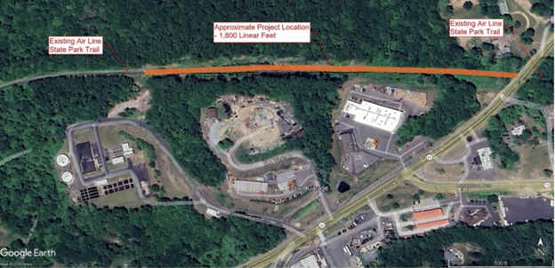
Note; Currently, as of 2025, a Gap exists East, to the next section in East Hampton. Construction planned for 2026. The plan is to construct an elevated 1400-foot boardwalk above the wetlands section that will allow trail users to cross through without disturbing the stream. See; Map Below & PROJECT PLANS .

Airline State Park Trail; East Hampton to Willimantic Section:
Starting in East Hampton from the Main Street parking lot;
Heading West:
From the Main Street parking lot; Travel up Main St to the cross-walk and head left across Main St up Barton Hill Rd. Turn left through the Fire Dept parking lot to reach the rail trail. Informational board here, along with an exercise station. The Airline SP Trail heads Southwest, into the woods past the old RR Station on your right. Cross Forest St at 0.5 miles where you'll pass through a rock cut and along a high berm across Muddy Gutter Brook. The trail then parallels Route 16, crossing over Pine Brook before coming to Aldens Crossing after 1.8 miles. The trail pulls away from Route 16 traveling along a causeway through a marsh. As you exit the marsh look left to spot the old iron RR Rail Holders. + See; RR Rail Holders Below. You enter a tunnel underneath Route 66 after 2.3 miles.
Note; Currently, as of 2025, a Gap exists West, to the next section in East Hampton. See; Map Above.
Heading
East:From the Main Street parking lot in East Hampton; The stone-dust Airline SP Trail travels East, up a ramp and across a bridge utilizing the old RR abutments, then back down and across Watrous St. It then heads up into the woods. After passing through a rock cut you cross Smith Rd and pass through the Smith Road parking lot after 0.7 miles. Here you'll find a Map Board and picnic tables next to Cranberry Bog. This area was once a natural cranberry producing bog. Heading East, the trail heads back into the woods, traveling over many berms and through many rock cuts (created by the RR) along its route. Cattle Lot Brook shadows the trail along your left. Pass the [1 Mile Marker] on your right after 1.7 miles. Mileage Markers are located every Mile along the trail starting from the Smith Road parking lot. After 2 miles you’ll come to the Rapallo Viaduct. This was originally a railroad bridge built in 1873 and spanning 1,380 feet, 60 feet above Flat Brook. However, in 1913, the span was filled in because the bridge could no longer carry the weight of the new freight trains. After crossing the open viaduct the trail then heads back into the woods. At 3.2 miles you’ll come to the Lyman Viaduct. This was once a 1,108 foot railroad bridge crossing 137 feet high over Dickinson’s Brook. This was also filled in around 1913. A couple of blue picnic tables are located here. Spot the iron buried in the trail. That is part of the old RR bridge that was buried long ago. Better views of the surrounding hills from this viaduct. Again, the trail heads back into the woods and at 3.7 miles, you’ll come to the Bull Hill Road parking lot. A better Map Board here, which also highlights points along the trail.
Note; The trail continues across Bull Hill Rd, however, you may wish to take a side trip to see the Comstock Covered Bridge that crosses the Salmon River. Go right, South, down Bull Hill Rd which becomes Comstock Bridge Rd for approximately 1 ½ miles. The bridge will be on your left.
Continuing Northeast, along the trail, which now travels along a ridgeline, the Salmon River parallels the trail far below. When you cross a culvert under the trail at 4.9 miles, look right and you should have a good view of the river. You’ll cross the River Road Bridge which was built in 1887. This 22 foot long brownstone arch bridge crosses over River Rd. A trail leads down to the road. Next, you come to a wooden bridge that crosses high above the Blackledge River at 5.3 miles. After crossing the bridge the landscape levels out, traveling through forest and wetlands. Still plenty of berms and rock cuts however. Cross River Rd again at about 6.1 miles and pass by a nice marsh on the left full of lily pads. Cross a causeway through Day Meadow Brook. Travel past the Route 149 parking lot and across Route 179 at 6.5 miles. The Jeremy River parallels the trail down along your right. You come to the Route 2 parking lot in Colchester at 7 miles. Pass through and exit the commuter lot, heading right for a short jaunt along Route 149 (wide shoulder). After traveling underneath Route 2 the trail picks up again on your right and returns you to the rail trail. Come to the Old Hartford Road parking lot at 7.2 miles where you'll find another Map Board. At 8.1 miles you’ll cross over an old iron RR bridge which traverses high over Jeremy River. A hop, skip and a jump brings you to a wooden bridge over the Judd Brook. At 9.2 miles look to your right to spot part of an old RR Rail Holders. + See; RR Rail Holders Below. Cross Grayville Rd followed by Old Colchester Rd at 10 miles. Now you’ll travel along a causeway through Raymond Brook Marsh. Full of lily pads, beaver huts and wildlife. Beautiful. Just before the [10 Mile Marker] at 10.7 miles is where the Airline State Park Trail; Colchester Spur begins on the right.
Note; The Airline State Park Trail; Colchester Spur takes you South, to Colchester and the old Colchester RR Station.
Continuing onward you'll reach the Route 85 parking lot in Amston at 11.1 miles. A Map Board is located here. Follow the trail Northeast, across Route 85. Cross light. The stone-dust trail starts out a bit narrow until you cross the next road. Here, the trail widens as it goes along a small berm. Next, you come to Route 207 and a Map Board. Cross light leads to a dirt parking lot at 11.8 miles. The trail passes by a large swamp to your left where I spotted a Blue Heron. At 12.3 miles a small stream is down to your left. You pass beneath some power lines and come to a rock outcrop at 13 miles. You'll cross over a high berm with steep drop offs and a view of Lake Williams below on your right. Continuing along the trail, you come to Leonard Bridge Road after 13.8 miles. Cross the road and bear right. The trail continues down past the yellow gate. You'll cross over a couple of wooden bridges before reaching Chesbro Bridge Rd at 14.7 miles. This next section travels through deep woods with many berms. You come to Route 87 at 16.1 miles. Use the cross-walk over the road and follow a short paved road and past a yellow gate to return to the trail. A lot of old junked cars and a bus here. You'll cross a culvert diverting Ten mile River under the trail and come to Cook Hill Road at 16.9 miles. A small parking lot is located here. Cross the road and travel down a berm where you'll travel past a farm and fields before reentering the woods. Cross Village Hill Rd at 18 miles where you'll find a parking area. The stone-dust trail continues North, past the yellow gate where you'll travel through the woods over a small berm and across a bridge. After passing underneath some transmission lines and traveling over a high berm you'll cross Kingsley Road in Lebanon after 18.9 miles. Small parking lot located here. After traveling underneath more transmission lines a berm takes you to an old RR trestle across the Willimantic River at 19.4 miles. After crossing over the Willimantic River you come to the intersection of both the Airline State Park Trail; North and Hop River State Park Trails in Willimantic.
Note; Heading left, West, is the start of the paved Hop River State Park Trail which travels alongside the Willimantic River. This trail takes you to Manchester.
Note; Heading straight is the start of the paved Airline State Park Trail; North which travels East, alongside the Willimantic River, passing by the CT EASTERN RAILROAD MUSEUM and bringing you out to the Bridge Street parking lot in Willimantic.
Old Railroad Equipment:
+
RR Rail Holders:
RR Rail Holders were used to store extra
railroad track alongside the train tracks. Usually made of iron or concrete, the
top is shaped like a small U to keep the tracks from falling off. I
assume these were used to keep the rails off the ground and quickly available if
needed. Couldn't find any information on them.
HH
CLICK HERE FOR AIRLINE SP TRAIL MAPS
CLICK HERE FOR CT TRAIL FINDER; AIRLINE SP TRAIL MAP
BEFORE YOU SET OUT BE SURE TO READ THE
WAIVER OF RESPONSIBILITY AND DISCLAIMER
BIKE IT OR HIKE IT