ACUSHNET RIVERWALK:
BROOKLAWN PARK LOOP:
NEW BEDFORD-ACUSHNET, MASSACHUSETTS
-BIKE IT OR HIKE IT-
Last Updated: May 05, 2026
Length: Acushnet Riverwalk; Riverside Park; 0.4 miles
Acushnet Riverwalk; Rivers End Park/The Sawmill; 1.3 miles
Brooklawn Park Loop; 1.8 miles
Difficulty: Acushnet Riverwalk; Riverside Park; Easy. Flat paved trail.
Acushnet Riverwalk; Rivers End Park/The Sawmill; Easy. Wide sidewalk & stone-dust trails.
Brooklawn Park Loop; Easy. Flat paved trail w/some on-road & sidewalk sections.
Directions:
To Start from the Riverside Park parking lot for the Acushnet Riverwalk; Riverside Park Section;
From I-195 Westbound; Take exit 28 to Veterans Memorial Way and follow to Sawyer St, heading left. Turn right on Belleville Ave, pass the park and turn right on Coffin Ave. Parking lot is on your right.
From I-195 Eastbound; Take exit 27 to Washburn St. First right on Belleville Ave, pass the park and turn right on Coffin Ave. Parking lot is on your right.
To Start from The Sawmill parking lot for the Acushnet Riverwalk; Rivers End Park/The Sawmill Section;
From Route 140 Northbound; Take exit 4 to Kings Hwy, which becomes Tarklin Hill Rd.
The Sawmill; Just before a bridge over the river turn left on Mill Rd. The parking lot will be on your left.
Rivers End Park; Just before a bridge over the river turn right on River Rd. The parking lot will be on your left.
From Route 140 Southbound; Take exit 4 to Mt Pleasant St and head left. Take your first right on Kings Hwy, which becomes Tarklin Hill Rd. Just before a bridge over the river turn left on Mill Rd. The parking lot will be on your left.
The Sawmill; Just before a bridge over the river turn left on Mill Rd. The parking lot will be on your left.
Rivers End Park; Just before a bridge over the river turn right on River Rd. The parking lot will be on your left.
To Start from the Brooklawn Street parking for the Brooklawn Park Loop;
From Route 140 Northbound; Take exit 4 to Kings Hwy, which becomes Tarklin Hill Rd. Just before a bridge over the river turn left on Mill Rd. The parking lot will be on your left.
From Route 140 Southbound; Take exit 4 to Mt Pleasant St and head left. Take your first right on Kings Hwy and your next right on Park Ave. Next right on Church St, then left on Wood St. Come to Acushnet Ave and turn right, then quickly right along Brooklawn St (one-way). First parking spaces on left.
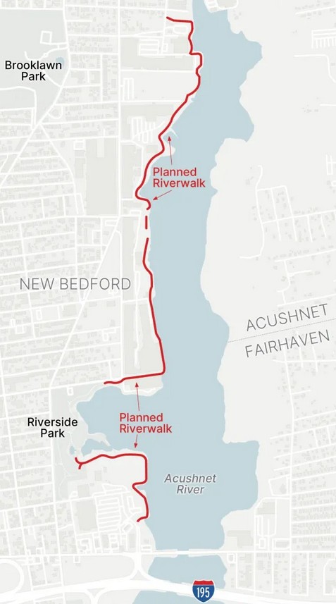
The Acushnet River flows 8.6 miles into Buzzards Bay. The name "Acushnet" comes from the Wampanoag or Algonquian word, "Cushnea", meaning "as far as the waters". The Acushnet Riverwalk will start from Veterans Memorial Way, just North, of I-195, and extend North, alongside the Acushnet River, to Riverside Park. It will then utilize the existing paved trails through the park (playground, sports fields & courts, Skate Park and Porto-Potty) out to Coffin St. Riverside Park parking lot located off Coffin St. The trail will continue along Coffin St, back to the river, then North to the Riverfront Lofts, where a short trail exists. Continuing North, the trail will end at the Slocum Street Bridge. You'll also be able to connect West, on-road to the Brooklawn Park Loop.
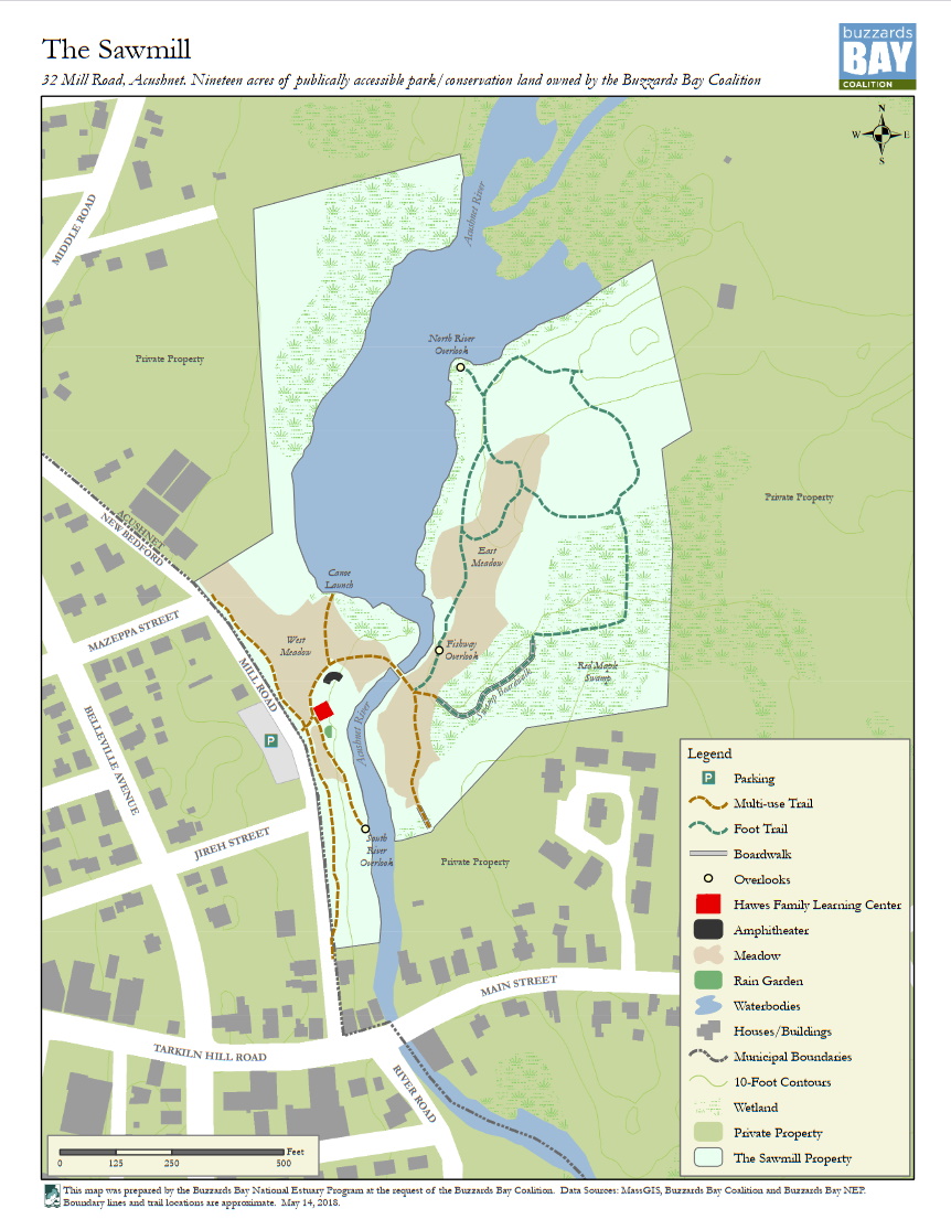
If you continue North, on-road along River Rd, you'll come to Rivers End Park, which is alongside the river and has paths and benches. Parking lot here. If you continue North, on-road along River Rd to Main St, turn left, then right along Mill Rd, you'll pick up a sidewalk that will bring you to The Sawmill (located in Acushnet). Parking lot here. The Sawmill was once home to a large, bustling lumber yard owned by the Acushnet Saw Mills Company. This is a reserve along the river and contains multi-use trails, along with pedestrian paths. A bridge crosses over the river, their is an overlook of Mill Pond, an amphitheater and the Hawes Family Leaning Center. For more information visit; ACUSHNET RIVERWALK & THE SAWMILL .
Acushnet Riverwalk:
Southern Section:
Starting from Sawyer Street in New Bedford for the Acushnet Riverwalk; Riverside Park Section [Southern End]; The wide, paved Riverside Park Trail travels North, through the open park past multiple picnic tables. Quickly come to an intersection where the trail splits. Both routes rejoin each other. The left, Western Route parallels Belleville Ave with more picnic tables. I headed right, along the Eastern Route, which is closer to the Acushnet River. The trail briefly splits again around a small pond. Right, the trail crosses a small bridge next to the river. Come to another intersection (this is where the Western Route rejoins the trail) and continue right, past a pavilion and playground, alongside the river. Pass a sports field and come to a skateboard park and the Coffin Ave parking lot at 0.3 miles. Trail turns right, East, passing by another sports court and garden before traveling alongside Coffin Ave and ending at Riverside Ave after 0.4 miles.
Northern Section:
Starting from Rivers End Park in New Bedford for the Acushnet Riverwalk; Rivers End Park/The Sawmill Sections [Southern End]; Rivers End Park overlooks a marsh and the Acushnet River. Informational signs and a narrow stone-dust trail above the river take you North, to a cement overlook with picnic tables. A stone path then takes you back to the parking lot after 0.1 miles. Head back out to River Rd and travel right, on-road (sidewalk available) to Tarklin Hill Rd and head left, then right, along Mill Rd. Pick up a wide sidewalk on your right after 0.3 miles. This trail enters The Sawmill, bringing you to the Hawes Family Learning Center. Left leads to The Sawmill parking lot. Informational signs all throughout the preserve. Multiple trails located on this preserve for both biking & hiking only. I've created a nice Loop that checks out all accessible bike trails.
Follow the stone-dust The Sawmill Loop right, South, as it quickly brings you to an overlook of the Acushnet River. Return to the Learning Center and travel North, to an *Intersection, next to a stone amphitheatre. Continue straight to an overlook of Mill Pond (part of the river). Return to the *Intersection and head left, East, across a bridge over the river to a 2nd **Intersection. Head right, South, along the Presidential Terrace to a dead end at a bridge over a brook. Return to the **Intersection and head right, East, along Maple Swamp, over a series of boardwalks through the swamp. Trail continues as a hiking trail. Return to the **Intersection and head right, North, along the North River Overlook, past a dam along a hard packed dirt trail. This brings you to an overlook of Mill Pond. Trail continues as a hiking trail. Return to the Hawes Family Learning Center, where the wide sidewalk continues North, alongside Mill Rd, ending after 1.3 miles.
Brooklawn Park Loop:
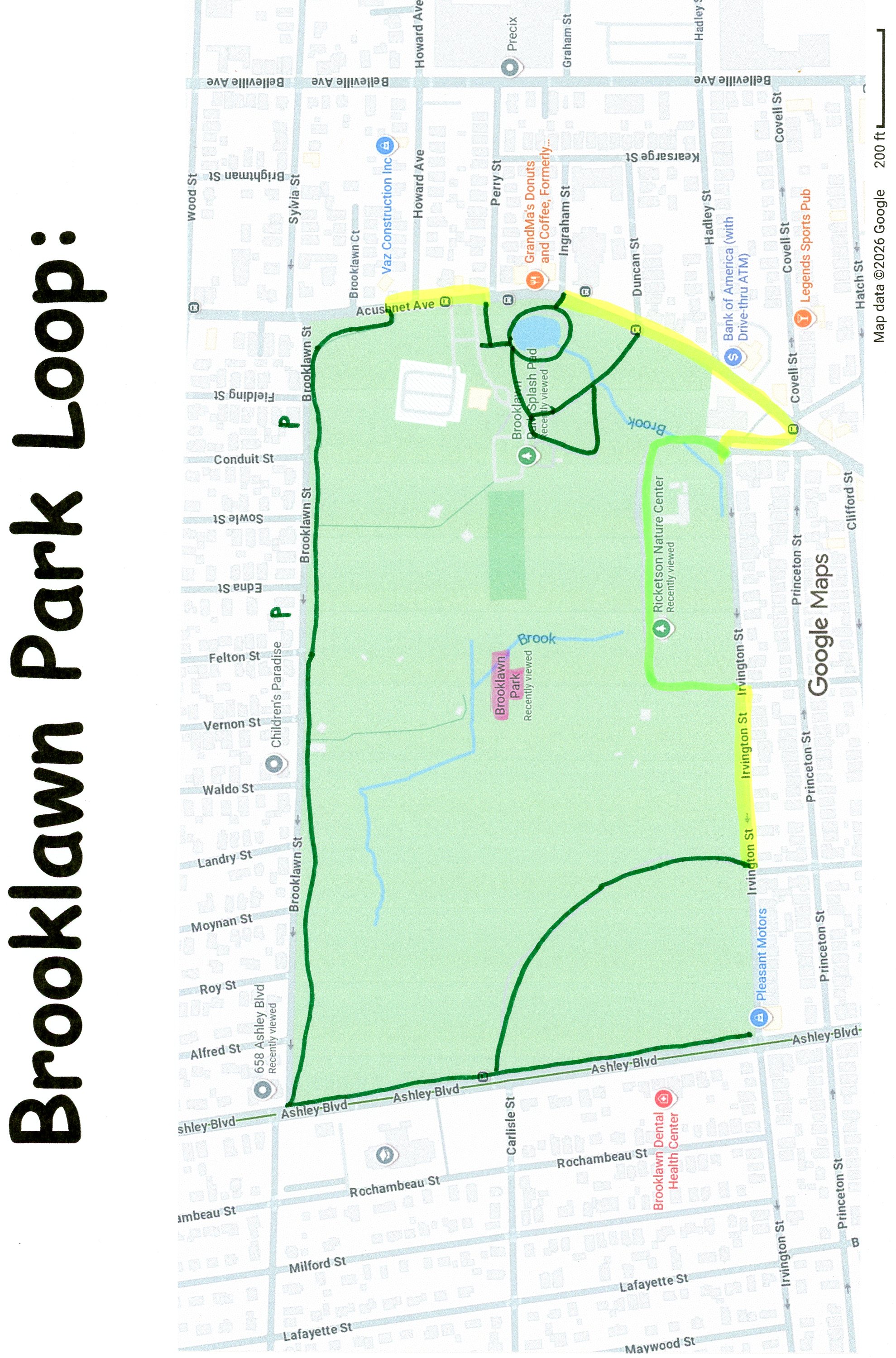
Starting from Brooklawn Street parking [Eastern End]; The paved Brooklawn Park Loop travels East, then South, along the edge of the park. Come to a short set of stairs down to a sidewalk and head right, alongside Acushnet Ave. Quickly pass by the park entrance and pick up a narrow paved trail between 2 granite posts. Enter the park and head left to a paved trail that Loops around a small pond with a tiny house on a small island. Cross a small brook and a bridge, completing the Loop. Head left along a sidewalk, up past the Community Center, then between a playground and splash park to a closed off road, which takes you back out to Acushnet Ave. Head right along a double sidewalk to Irvington Ct on your right. Follow this North, past the Library and back into the park along an entrance road (low traffic). Pass by sports fields and the Ricketson Nature Center, before exiting the park back out to Irvington St. Head right, on-road (one-way/sidewalk available) a short distance before you pick up an old paved road on your right. This takes you North, through open woods out to Ashley Blvd.
Note; A wide, paved trail travels South, alongside Ashley Blvd, 0.2 miles to Irvington St.
Head right, North, along the wide, paved trail alongside Ashley Blvd to Brooklawn St. The trail continues right through open woods alongside the road. Pass by the ball fields and complete your Loop after 1.8 miles.
HH
CLICK HERE FOR THE ACUSHNET RIVERWALK MAP
CLICK HERE FOR THE ACUSHNET RIVERWALK MAP
CLICK HERE FOR THE SAWMILL MAP
CLICK HERE BROOKLAWN PARK LOOP MAP
BEFORE YOU SET OUT BE SURE TO READ THE
WAIVER OF RESPONSIBILITY AND DISCLAIMER
BIKE IT OR HIKE IT