SETAUKET-PORT JEFFERSON STATION GREENWAY:
PORT JEFFERSON-SETAUKET, LONG ISLAND, NEW YORK
NORTH SHORE RAIL TRAIL:
MT SINAI-WADING RIVER, LONG ISLAND, NEW YORK
-BIKE IT OR HIKE IT-
Last Updated: April 12, 2025
Length: Setauket-Port Jefferson Station Greenway; 3.4 miles
North Shore Rail Trail; 10.6 miles
Difficulty: Setauket-Port Jefferson Station Greenway; Moderate. Paved trail with many hills.
North Shore Rail Trail; Easy. Flat, paved rail trail.
Directions:
To Start from the Limroy Lane parking lot in Setauket for the Setauket-Port Jefferson Station Greenway [Western End]; From I-495 take exit 62 to Route 97 north to Route 25A. Turn right and travel a 1/2 mile to Limroy Lane. Turn right and follow to the parking lot on your left.
To Start from the Patchogue Road/Hallock Ave parking lot in Port Jefferson for the Setauket-Port Jefferson Station Greenway [Eastern End]; From I-495 take exit 63 to Route 83 north. After 4.5 miles turn left onto Route 112. Follow 4 miles to the junction of Route 25A. Turn left and travel to the end of the parking lot where you'll find the trailhead.
To start from the Wading River School parking lot in Wading River for the North Shore Rail Trail [Eastern End]; From Route 25A in Wading River, follow Wading River Manor Rd north to the school on your right. Trail head is just past the school. Not sure if there are parking restrictions during school hours.
To start from the Prince Road parking lot in Rocky Point for the North Shore Rail Trail [Center Section]; From Route 25A in Rocky Point, follow Broadway north to Prince Rd and turn right. Parking lot on your left. This parking lot was built over the former rail bed.
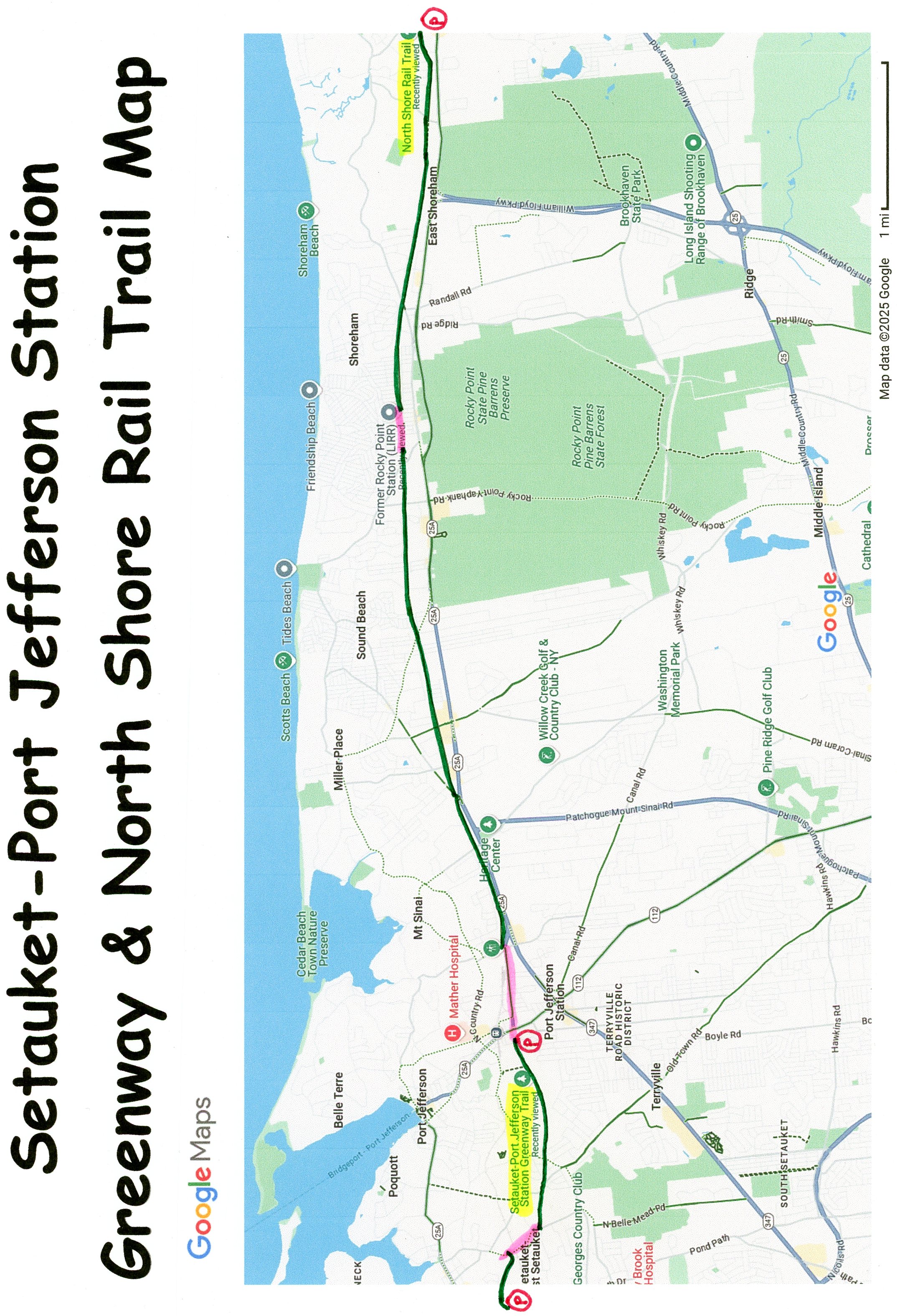
The Setauket-Port Jefferson Station Greenway is a paved trail that travels from Setauket East, to Port Jefferson along a hilly, winding trail. A BIKE LANE continues East, connecting to the North Shore Rail Trail in Mt Sinai. This trail continues East, along the former Long Island RR right-of-way, owned by the Long Island Power Authority, to Wading River. For more information visit; Setauket-Port Jefferson Station Greenway .
Setauket-Port Jefferson Station Greenway:
Starting from the Limroy Lane parking lot in Setauket [Western End]; A Map Board is located here. The paved Setauket-Port Jefferson Station Greenway travels East, down hill through the woods to Gnarled Hollow Rd, where a SEPARATED BIKE LANE travels right, South, for 0.2 miles. Use Caution traveling through a tunnel underneath the RR bridge. Come to the Gnarled Hollow Road parking lot after 0.8 miles on your right and pick up the paved trail again. Map Board. Here the trail climbs up through the woods crossing Gnarled Hollow Rd a 2nd time at 1.2 miles, as the trail turns East. Another hilly section before crossing Old Town Rd at 1.6 miles. This next section has several residential road crossings, before you cross Sheep Pasture Rd at 2 miles, followed by Possum Lane. Finally you wind through open woodland before coming to the Patchogue Road/Hallock Ave parking lot in Port Jefferson after 3.4 miles. [Eastern End] A Map Board is located here.
Note; If you travel through the parking lot out to Patchogue Rd and cross the street you'll pick up a BIKE LANE that follows Hallock Ave East. After 1 mile you'll come to Crystal Brook Hollow Rd. Turn left and you'll pick up the paved North Shore Rail Trail on your right.
North Shore Rail Trail:
(I haven't checked out this trail yet)
Starting from Crystal Brook Hollow Road in Mt. Sinai [Western End]; Map Board. The paved North Shore Rail Trail travels East, along the old rail bed, following an open transmission line. Several road crossings, before crossing busy Echo Ave at 1.8 miles. Trail briefly follows Echo Ave, before returning to the transmission line corridor. Cross into Miller Place. Again, multiple street crossings. Cross N Country Rd at 3.8 miles, as you briefly travel through Sound Beach to Rocky Point. Multiple street crossings. Come to Rocky Point Landing Rd at 5.6 miles. The trail detours off the old rail bed here, traveling around an electrical sub-station, before returning to the old rail bed. Come to Prince Rd at 6.2 miles, where a short on-road, detour takes you left, East, across Broadway, past the Prince Road parking lot on your left. Spot the old Rocky Point RR Station across the parking lot. Come to Tyler St on your left and return to the paved trail. Cross over Woodville Rd (tunnel below) in East Shoreham, before crossing Briarcliff and N Country roads at 7.5 miles. The former East Shoreham RR Station was located here. Multiple street crossings before the trail briefly becomes more isolated. Several more street crossings, before coming to Wading River Manor Rd in Wading River, after 10.6 miles and the end of the trail. Across the street is the Wading River School parking lot.
HH
CLICK HERE FOR SETAUKET-PORT JEFFERSON GREENWAY MAP
CLICK HERE FOR NORTH SHORE RAIL TRAIL MAP
CLICK HERE FOR LONG ISLAND BIKE MAP
BEFORE YOU SET OUT BE SURE TO READ THE
WAIVER OF RESPONSIBILITY AND DISCLAIMER
BIKE IT OR HIKE IT