O&W RAIL TRAIL:
MOUNTAINDALE to HURLEYVILLE, NEW YORK
HURLEYVILLE MILK TRAIN TRAIL:
HURLEYVILLE, NEW YORK
LIBERTY RAIL TRAIL:
LIBERTY, NEW YORK
PARKSVILLE RAIL TRAIL:
PARKSVILLE, NEW YORK
-BIKE IT OR HIKE IT-
Last Updated: July 23, 2026
Length: O&W Rail Trail; Mountaindale to Woodbridge Section; 3.2 miles
O&W Rail Trail; Woodbridge Section; 1.8 miles
O&W Rail Trail; Fallsburg Tunnel Bypass Trail; 0.9 miles
O&W Rail Trail; South Fallsburg to Hurleyville [Hurleyville Milk Train Trail]; 5.3 miles
Liberty Rail Trail; 2.6 miles
Parksville Rail Trail; 1.3 miles
Difficulty: O&W Rail Trail; Mountaindale to Woodbridge Section; Easy. Flat, hard packed dirt, cinder & grass trail. Includes on-road section.
O&W Rail Trail; Woodbridge Section; Moderate. Mostly flat, hard packed dirt, gravel & cinder rail trail.
O&W Rail Trail; Fallsburg Tunnel Bypass Trail; Moderate to Difficult. Wide, crushed gravel, steep trail. Not recommended for kids on bikes.
O&W Rail Trail; South Fallsburg to Hurleyville [Hurleyville Milk Train Trail]; Moderate. Flat, hard packed dirt & grass rail trail for first 1.8 miles. Easy. Hurleyville Milk Train Trail, Flat, paved rail trail.
Liberty Rail Trail; Moderate. Flat, rail trail with varying surfaces. Old asphalt, road, grass, hard packed dirt, cinder & gravel.
Parksville Rail Trail; Moderate. Mostly flat stone-dust, hard packed dirt, gravel and grass rail trail. Mt bike recommended.
Directions:
To start from Woodridge/Mountaindale for the O&W Rail Trail [Southern Section]; From Route 17 take exit 105B to Route 42 north to downtown South Fallsburg. From South Fallsburg continue north on Route 42. Turn right on Old Falls Rd (Route 53) and follow to Woodridge, now Roosevelt Ave. As you enter the town the Northern Section of the trail starts on your right, by the small pavilion. Parking available on your left along Green Ave [Northwestern End] Continue along Green Ave Ext (Route 53) through town. This is also part of the on-road detour for the trail to the Southern Section. You come to the Southern Section and small parking area straight ahead [Southeastern End]. Turn right up Greenfield Rd, then left onto Mountain Dale Rd (Route 54) and into Mountaindale. Turn left on Old Post Hill Rd and then left down Railroad Ave to the Railroad Ave parking lot [Southeastern End]. Cinder Track Bikes is located here. Unable to find a web site however.
To start from the Landau's Park parking lot in South Fallsburg for the O&W Rail Trail [Central Section]; From Route 17 take exit 105B to Route 42 north to downtown South Fallsburg. Turn left on Railroad Plaza Ext and come to Griff Rd. The parking lot is on your left. The trail starts north up Griff Rd, then left along Water St and just past a basketball court.
To start from the Hurleyville parking lot for the Hurleyville Milk Train Trail [Central Section]; From Route 17 take exit 105B to Route 42 N. Take your first left on Route 103 and travel 4 miles to Anawana Lake Rd and turn left, then right along Columbia Hill Rd. Follow to downtown Hurleyville. Parking lot on your right where trail crosses road.
To start from Chestnut Street in Liberty for the Liberty Trail [Northern Section]; From Route 17 take exit 99 to N Main St and head left. Turn right at the intersection of S Main St & Chestnut St (Route 52). Trailhead on left just before a sharp left turn.
To start from the Old Route 17 parking lot in Parksville for the Parksville Rail Trail [Northern Section; Northern End]; From Route 17 take exit 98 to Short Ave and head east to Parksville Rd. Head left and travel 1.4 miles. Parking lot is on your left.
In Sullivan County plans are to complete a Rail Trail along the former rail bed of the New York, Ontario & Western Railroad [See; O&W HISTORICAL MAP ]. The O&W RR operated from 1868 until 1957 and ran from Weehawken, NJ to the shores of Lake Ontario, passing through the Southern Catskills. From its start in the late 19th century until its bankruptcy in the 1950’s, the route was mainly used for transporting people, coal, and dairy to and from rural communities across New York and the New York City metropolitan area. Currently, trails are complete along this old rail line from Mountaindale, Northwest, to Woodridge-the Fallsburg Tunnel Bypass Trail in South Fallsburg-South Fallsburg, Northwest, to Hurleyville-the Liberty Trail in Liberty and the Parksville Rail Trail in Parksville. See; O&W RAIL TRAIL .
2 Sections of the old O&W RR intersect in Summitville. Summitville was a Junction Point, where passengers could disembark and take the branch line Southwest, to Monticello, or Northeast, to Ellenville and eventually Kingston. It was here that the O&W also crossed paths with the remains of the Delaware and Hudson Canal. For more information visit; O&W Rail TRAIL; SULLIVAN COUNTY .
From Summitville; Heading Northwest, the old rail bed is undeveloped until Mountaindale, where the O&W Rail Trail (with Gaps) continues to Hurleyville & the Hurleyville Milk Train Trail. Another Gap exists between the next section, Northwest, to Liberty and the Liberty Rail Trail. Another large Gap exists Northwest, to Parksville and the Parksville Rail Trail. For more information visit; HURLEYVILLE RAIL TRAIL .From Summitville; Heading Southeast, the old rail bed is undeveloped to Middletown, where you can connect to the Heritage Trail , which travels Southeast, through New Hampton, Goshen, Chester, Monroe to Harriman.
In Summitville, the old O&W RR traveled roughly North-South, from Kingston in the North, to Port Jervis in the South. See; D&H Canal Trail-O&W Rail Trail Corridor .
Sullivan O&W Rail Trail; Regional Trail Plan Study
O&W Rail Trail; Mountaindale to Woodridge Section:
Southern Section:
Starting from the Railroad Ave parking lot in Mountaindale [Southeastern End]; From the old Mountaindale Train Station, now a Visitor Center, with restrooms, head past the parking lot and you'll come to a sign board for the Mountaindale O&W Linear Park. Head Northwest, into the woods along the wide, hard packed dirt, cinder & grass trail following alongside Sandburg Creek. Mile Markers every 0.5 miles starting from the train station. Leave the stream behind after crossing Hatt Rd. Trail parallels Route 54 and crosses Quiat Rd at 1.2 miles where you'll find a small parking area. Here you'll find an original O&W RR Signal House that was moved to this location. + See; RR Signal House Below. Cross Silver Lake Rd at 1.7 miles and the trail becomes more isolated. Travel across a causeway between Silver Lake, then head back into the woods. Come to the end of the trail after 2.7 miles at the Greenfield Road parking area in Woodridge. Woodridge Rail Trail sign overhead.
Note; To reach the next section in Woodridge you'll need to travel on-road. Continue straight, Northwest, along Green Ave Ext (narrow shoulder). You'll pass by a small RR park on your right that contains an old RR Crossing Sign, some tracks and a miniature train planter. The road shoulder is wider along this next section. You'll travel past a kiosk, on the left side of the road, that explains the history of the O&W RR. Across the street is parking along Green Ave at 0.3 miles. You'll then come to Veteran's Memorial Park on your left after 0.5 miles [3.2 miles] and the start of the Woodridge-South Fallsburg Section.
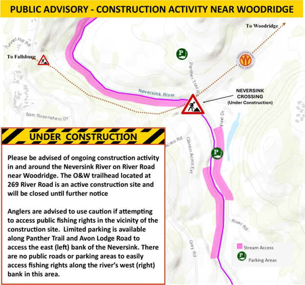
Continuing from Veteran's Memorial Park in Woodridge [Continuing Mileage]; From the gazebo and sign board at Veteran's Memorial Park alongside Roosevelt Ave/Green Ave Ext (Route 53) the gravel based O&W Rail Trail heads down a slight hill through the woods heading Southwest. The trail follows an open gravel road with a few potholes and loose stones. Pass by a wooden Mile Marker 3 on your left? After 3.7 miles you'll bear right and re-join the rail trail. Brown O&W sign marker. The trail heads into the woods along a hard packed dirt & cinder surface with the occasional root. Some ATV use apparent. Travel across a causeway at 4.2 miles through a marsh before re-entering the woods. The trail parallels River Rd on your right and ends at the River Road parking lot after 5 miles. The old bed ends straight ahead, just above River Rd, where an old RR bridge over the Neversink River used to exist.
Note; A new bridge over the river has been installed, but work is still underway, as of July 2026.
Note; Across the Neversink River, the undeveloped rail bed continues Northwest, 0.9 miles to the old *Fallsburg RR Tunnel (1,123 foot long brick tunnel constructed in 1886 as part of the historic Ontario & Western (O&W) Railroad) in South Fallsburg. See; O&W Rail Trail; South Fallsburg Below for the next section.
O&W Rail Trail; South Fallsburg to Hurleyville Section [Hurleyville Milk Train Trail]:
Central Section:
O&W Rail Trail; Fallsburg Tunnel Bypass Trail:
Starting from Dogpatch Town Park in South Fallsburg for the O&W Rail Trail; Fallsburg Tunnel Bypass Trail [Western End]; You'll find a BIKE STATION, sports fields, playground and of a Dog Park here. Exit the park and turn right, along Old Country Rd, which quickly brings you to the trailhead. Map Board. This trail does not follow the old rail bed, but instead was designed to by-pass the old Fallsburg RR Tunnel (1,123 foot long brick tunnel constructed in 1886 as part of the historic Ontario & Western (O&W) Railroad). The wide, crushed gravel O&W Rail Trail travels East, up a steep, switchback trail/road. You top out, then head downhill, crossing the gravel Willow Heights Rd, coming to an intersection at 0.6 miles. Map Board & BIKE STATION located here.
Note; Left leads to a cliff overlook. Picnic tables.
This was as far as I traveled. The crushed gravel trail continues South, downhill, along a switchback. You come to the old rail bed after 0.9 miles. I believe to your right is the old *Fallsburg RR Tunnel. Left, East, the old rail bed travels through the woods. Don't know if it's ridable or even open.
Note; Future construction will continue the trail Northeast, 0.9 miles along the old rail bed to the Neversink River. Construction of a new bridge over the river is underway, as of July 2026.
To connect to the next section in South Fallsburg; You'll need to travel on-road. From the O&W Rail Trail; Fallsburg Tunnel Bypass Trail, head left, Southwest, along Old Country Rd, then right along Dogpatch Rd (residential), left along Doohickey Ln (residential) to Lake St. Head right, North, on-road along Lake St to Railroad Plaza (gravel road next to a small brick building) on your right at 0.5 miles. Follow this road out to the paved Railroad Plaza (old rail bed). Continue North, past the Town Hall & Library and across Main St, along Railroad Plaza Ext. Pass by Landau's Park parking lot, on your left at 0.8 miles and come to Griff Ct. Bare right, then left along Water St, past an old concrete RR bridge and basketball court to the O&W Rail Trailhead after 0.9 miles.
Starting from Landau's Park parking lot in South Fallsburg [Southeastern End]; [Re-zeroing Mileage]; The narrow, hard packed dirt & crushed gravel O&W Rail Trail begins behind the basketball court (Map Board) and travels Northwest, through the woods. Cross La Vista Dr at 0.5 miles (Map Board) and then travel alongside a small pond. Some washouts along this section. Cross over Westwood Dr at 0.9 miles. This heavily wooded section has a nice crushed gravel base but hasn't been maintained, so mind the roots. You'll catch glimpses of Alta Lake along your right. You come alongside Westwood Dr briefly before heading back into the woods along a moderate berm. Return to Westwood Dr at 1.8 miles. Travel right a short distance up Westwood Dr where the trail continues across the road.
Hurleyville Milk Train Trail:
This is the start of the wide paved Hurleyville Milk Train Trail. [Continuing Mileage] This next section is the most scenic. The trail returns to woods and you pass through a rock cut at 2.2 miles. Informational signs located all along the trail. The trail turns West and crosses a long causeway through a scenic marsh. The East Mongaup River passes through the marsh. You come to Main St in Hurleyville at 3 miles. Hurleyville parking lot located here along with a playground, sports courts and garden. Map Board & BIKE STATION. Cross Route 104 to Railroad Ave (sidewalk). Pass by the old O&W Hurleyville RR Station. Past the station on your left you'll pick up the paved trail again as it travels past the Railroad Ave parking lot. Map Board. The trail here is partly shaded as it heads Northwest. Travel along another causeway through a marsh for the East Mongaup River before crossing Krum Rd where the trail enters the woods. Cross the East Mongaup River at 4.6 miles. The river briefly travels below right. Come to Denman Rd after 5.3 miles where the paved trail ends. This was as far as I traveled. The trail continues West, as hard packed dirt, grass, cinder and gravel another mile to Old Monticello Rd and the Ferndale border.
Note; Past Old Monticello Rd, I'm not sure if the trail is ridable. The old rail bed is then blocked by Route 17.
Liberty Trail:
Northern Section:
Starting from Chestnut Street in Liberty [Northwestern End]; A Map Board is located here next to a small parking area. Picnic table. The crushed gravel trail follows the old rail bed South, along an old road to a cul-de-sac on Spur St. The trail then narrows as it continues to follow old State St (deteriorated blacktop/gravel) East, along a power line. Pass by a sub-station and gate at 0.6 miles, continuing on-road along State St, through an industrial area. Cross Lake St (Route 55) and continue on-road, along State St (low traffic) until it ends at 1.1 miles. Here you'll re-enter the rail trail (much more scenic now) as it travels South, into the woods and through a rock cut. Hard packed dirt, gravel, cinder and grass surface, rough in spots. Travel along a berm with a steep drop along the left. Cross Carrier St (Map Board), then Upper Ferndale Rd where you'll need to bear right to another Map Board to get past a gate at 1.6 miles. The trail now follows a power line along a grass trail before entering the deep woods along a grass and hard packed gravel surface. The trail improves with crushed gravel and cinder at 2 miles as you travel along a berm and ridgeline with another steep drop off. Pass through a deep rock cut and then the trail ends at 2.6 miles. A knifes edge leads to the top of a ridge where there must have been a long RR bridge in the past. You can hear the traffic from Route 17 in the distance.
Note; Past here, the old rail bed is blocked by Route 17.
Parksville Rail Trail:
Northern Section:
Starting from the Old Route 17 parking lot in Parksville [Northern End];
Note; Future construction will extend the trail North, 3.9 miles, to Rotary Park in Livingston Manor.
The trail starts out as stone-dust as you ascend a hill East, into the woods along the old rail bed. The Little Beaver Kill parallels the trail below. Cross a short boardwalk at 0.5 miles and pass by a small waterfall at 1 mile. Come to Short & Main Streets at 1.3 miles.
Note; If you continue right, South, across Short Ave and on-road along Main St you'll pass a small Veteran's Memorial before coming to the Main Street parking lot.
You can Loop back to the Old Route 17 parking lot by heading left, North, on-road along Main St, crossing over Little Beaver Kill to Parksville Rd. Here you'll pick up a stone-dust trail on your left at 1.4 miles, that travels West, alongside Parksville Rd. You'll pass by a picnic area and parking lot at 1.7 miles. I believe a path leads down to the waterfall from here. Pass by a 2nd parking lot at 2 miles where the stone-dust trail ends. Continue on-road (wide shoulder), crossing over Little Beaver Kill, where you'll pick up the stone-dust trail again, which returns you to the Old Route 17 parking lot after a 2.7 mile Loop.
Old Railroad Equipment:
+ RR Signal House:
RR Signal Houses contained the
equipment and operators necessary to set the signals that guided trains. The
role of a Signal House was for traffic control. They housed the signal
levers and mechanisms that controlled track signals, and signalmen worked in
these houses to set the signals for approaching trains.
HH
CLICK HERE FOR O&W RAIL TRAIL MAP
BEFORE YOU SET OUT BE SURE TO READ THE
WAIVER OF RESPONSIBILITY AND DISCLAIMER
BIKE IT OR HIKE IT