JESSE KREGAL PATHWAY:
BUFFALO, NEW YORK
-BIKE IT OR HIKE IT-
Last
Updated: October 27, 2025
Length:
Jesse Kregal Pathway;
2.8 miles
Hoyt Lake Loop Trail; 1.4 miles
Delaware Park Loop Trail; 1.7 miles
Difficulty:
Easy. Flat paved trail.
Directions:
To start from the Unity
Island parking lot on Unity
Island [Western
End]; This is the closest parking lot available. From here
you may also access the Erie Canalway Trail;
Rochester-Buffalo & Shoreline Trail.
From I-190 Northbound take exit 12 to Niagara St and
head right. Travel underneath the RR bridge and turn right next to a sign
reading "Squaw Island Park". A ramp takes you up to the Unity Island
Bridge and over to Unity Island. Follow the road straight and you'll come to the parking
lot.
From I-190 Southbound take exit 14 to Niagara St and
head right. Travel 1 mile, passing underneath a RR bridge and turn right
next to a sign reading "Squaw Island Park". A ramp takes you up to the
Unity Island Bridge
and over to Unity Island. Follow the road straight and you'll come
to the parking lot.
The Jesse Kregal Pathway,
formally known as the Scajaquada Creek Greenway, starts from the
intersection of Niagara St (next to the International RR Bridge & Black Rock
Canal) and the Erie
Canalway
Trail; Rochester-Buffalo & Shoreline
Trail and travels South,
to Scajaquada Creek. Here the trail follows Scajaquada Creek
East,
to Delaware Park. You can access 2 other trails along the way; Hoyt
Lake Loop Trail & Delaware Park Loop Trail.
Starting from
the Unity
Island parking lot on Unity
Island [Western
End]; Travel North,
along the Erie Canalway Trail;
Rochester-Buffalo & Shoreline Trail underneath the International
RR Bridge, then right, East, following the RR tracks to the International
RR Bridge across the Black
Rock Canal. After crossing the International RR Bridge you'll come to an intersection after
0.4 miles next to Niagara St.
Note; The Erie
Canalway
Trail; Rochester-Buffalo/Shoreline Trail continues
straight down the Unity
Island Bridge Ramp.
New signage and Maps have been added
since I rode this trail. Head left along the start of the Jesse
Kregal Pathway [Re-zeroing
mileage]. The paved trail travels South,
underneath the International RR
Bridge and above I-190 before crossing a bridge over
Scajaquada Creek and coming to an intersection at 0.3 miles.
Note; Right, West,
a paved trail travels underneath I-190 and alongside Black Rock
Canal to an overlook.
Head left, underneath a RR bridge and exit ramp out to
Niagara St passing by a green awning bench with an informational board.
Cross-light over Niagara St where the trail travels underneath an exit ramp out
to West Ave. Head left, North, along a short
on-road (low traffic) section and across
the creek where you'll pick up the paved trail on your right after 0.7 miles.
Here the isolated trail travels Northeast,
above
Scajaquada Creek.
Come to an intersection at 1.2 miles and continue straight underneath Grant St
as left brings you up to the West Side of Grant St. Come to the
East Side of
Grant St and head right across the
Scajaquada Expressway ramp where the trail continues on your right. The trail
continues East, alongside the creek passing by Peter Street Park and a
Spur
Trail out to Bush St. Pass by McKinley HS where the trail splits. Left
takes you up to Elmwood Ave, so keep straight underneath the off/on ramps for the
Scajaquada Expressway. Travel underneath Elmwood Ave and another ramp
where the trail surface now follows pavers at 2.1 miles as you travel below the BUFFALO
HISTORY MUSEUM and past a Japanese Garden and Cherry
Blossoms. This is
all part of Delaware Park. Come to a Pedestrian
Bridge on your right at
2.3 miles.
Note; Right,
South, leads to the
Hoyt
Lake Loop Trail. Travel across the
Scajaquada Expressway via a pedestrian bridge to a paved trail before
coming to an intersection next to the Statue of David. Continue straight,
West, to a bridge, then left, South,
across the creek to the trail on your left, East,
that circles the Southern Side of Hoyt Lake.
The trail turns to pavers as you enter a wide plaza. To your right you'll find a
Map Board. The stone steps lead up to the ALBRIGHT-KNOX
ART GALLERY . Pass by the stone Marcy
Casino, not a
real casino but an event venue. Behind this building is the Delaware Park
Rose Garden. Continuing alongside the Lake, the trail is paved again with
many spur trails along your right that you can explore. You'll follow a causeway
between the Lake and Creek (separated) before
heading back, Northwest, along the Northern
Side of the Lake. Come to an intersection and
head right back to the Statue of David,
then right, North,
returning to the pedestrian
bridge back over the
Scajaquada Expressway, returning back to the
Jesse
Kregal Pathway after a 1.4 mile
Loop.
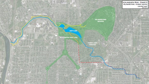
See; Map Below for
all the trails that travel through Delaware Park.

Continuing straight from the Pedestrian
Bridge, you'll pass by some
tennis courts before coming to an access ramp at 2.6 miles. Cross over to a
sidewalk and head right out to the
Scajaquada Expressway, then left across a bridge. This will bring you to
Meadow Dr at 2.8 miles and the end of the trail. Restrooms located here.
Note; I
haven't checked out this next section. You may continue along the
Delaware Park Loop Trail. Head right,
East, across Meadow Dr is access to a
stone-dust trail that encircles the Delaware Park Golf Course and sports
fields. Head either direction and about half way around you'll pass by the BUFFALO
ZOO . You'll complete the Loop after
1.7 miles.
Future
plans will continue a trail South, from Delaware
Park. See; Map Below "Red Line".
HH
CLICK HERE FOR MAP
BEFORE YOU SET OUT BE
SURE TO READ THE
WAIVER
OF RESPONSIBILITY AND DISCLAIMER
BIKE IT OR HIKE IT
HOME
PAGE