FORT HILL BRANCH RAIL TRAIL:
HINSDALE, NEW HAMPSHIRE
-BIKE IT OR HIKE IT-
Last Updated: December 9, 2024
Length: Fort Hill Branch Rail Trail; 6.9 miles
Difficulty: Moderate. Flat hard packed dirt, grass & gravel rail trail. Short gravel road section. Mt bike recommended.
Directions:
Take exit 1 off I-91to Route 5 north. Continue straight on Route 119, crossing over the Connecticut River into NH.
To Start from the Brattleboro Road parking lot [Center Section]; After 4.9 miles turn right at a dirt road to the parking lot. If you come to a pond on your right you went to far.
To Start from the Northfield Road parking lot [Southern End]; Continue south on Route 119. Turn right after 6.7 miles along Route 63 south. After 2 miles you'll come to the parking lot on your right.
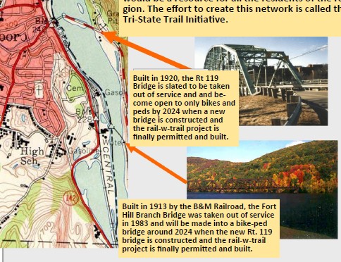
The Fort Hill Branch Rail Trail parallels the East Bank of the Connecticut River North, to an old railroad bridge that crosses the river to Brattleboro, Vermont. The bridge is out of commission. For more information visit; FORT HILL RECREATIONAL TRAIL .
Starting from the Northfield Road parking lot [Southern End]; The trail is reached by exiting the parking lot and heading right to the trailhead.
Note; Across the road is the trailhead for the Ashuelot Rail Trail .
Just past the gate you'll come to the old rail bed where you head North, along a well shaded trail. The Fort Hill Branch Rail Trail surface consists of hard packed dirt, grass & gravel. You get your first views of the Connecticut River after a 0.25 miles. Cross an old RR bridge over the Ashuelot River at 1.3 miles followed by a small bridge over a culvert at 1.8 miles. As you pass through several wide cuts the trail improves a bit. Views of the Yankee Nuclear Power Station across the river in Vermont. Pass by a gate at 2.9 miles and you'll now travel along a gravel road. To your right is the Prospect St boat launch. Follow the road across a causeway to another gate at 3.6 miles. To your right is the Brattleboro Road parking lot and to your left, a dirt & grass road will take you along a causeway out into the Connecticut River. Scenic. The trail continues traveling above the Connecticut River. Cross a causeway & culvert over Ash Swamp Brook at 4.4 miles, before the trail travels more inland. Come back above the river at 6.4 miles. Travel through a cut and pass by a long rock retaining wall at 6.9 miles. Past here the trail is just a narrow path and blocked by a large tree. About another 0.1 miles, you'll come to the old iron Boston & Maine Railroad Fort Hill trestle bridge, that crosses over the river to Brattleboro, VT.
Warning: The bridge has not been renovated and contains large gaps between the ties.
HH
BEFORE YOU SET OUT BE SURE TO READ THE
WAIVER OF RESPONSIBILITY AND DISCLAIMER
BIKE IT OR HIKE IT