CONNECTICUT FASTRAK TRAIL:
NEW BRITAIN-NEWINGTON, CONNECTICUT
BEELINE TRAIL:
NEW BRITAIN-PLAINVILLE, CONNECTICUT
-BIKE IT OR HIKE IT-
Last Updated: July 30, 2026
Length: CT Fastrak Trail; 4.5 miles
Beeline Trail; 1.4 miles
Difficulty: CT Fastrak Trail; Easy. Mostly flat paved trail. No Shade.
Beeline Trail; Easy. Flat paved trail.
Directions:
To Start from the New Britain Station [Southern End];
From I-84 Westbound take exit 39A to Route 9 south. Take exit 28A to E Main St and turn right. Take your second left on Main St. The Fastrak Station and start of the trail is on your left.
From I-84 Eastbound take exit 35 to Route 72 east. Take exit 8 to Columbus Blvd and follow to Main St. Left brings you to the Fastrak Station.
Note; No parking available at this station, so you can either park on-street or in one of the nearby shopping plazas or the Szczesny Municipal Parking Garage located at 35 Bank St. Fee.
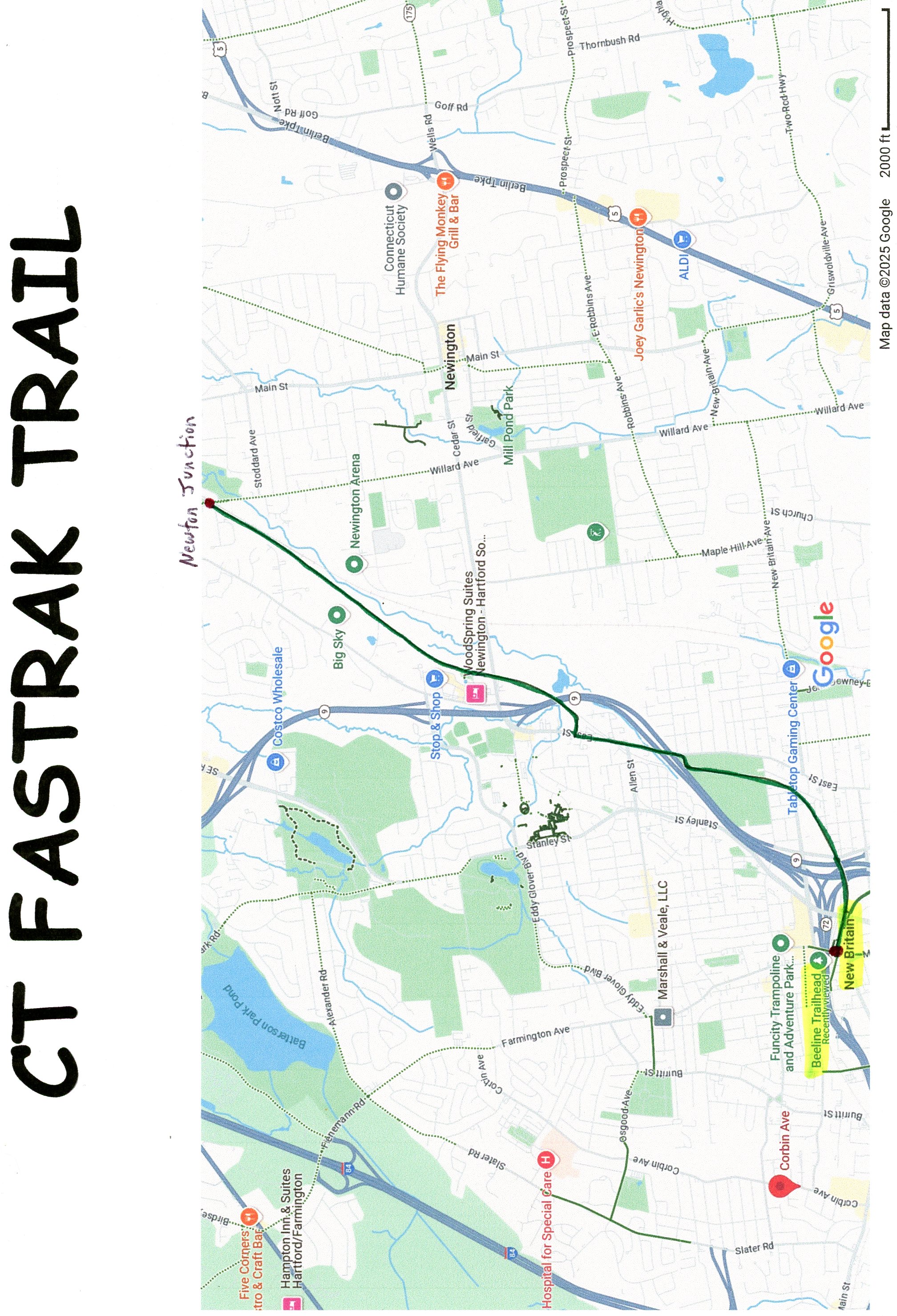
The CT Fastrak Trail is a paved multiuse trail that parallels the CT Fastrak Busway from the New Britain Station in downtown New Britain, North, to the Newington Station in Newington. The CT Fastrak Busway continues on to Hartford, however, the trail stops in Newington because there was no room to continue the trail along the Busway North, towards Hartford. From the Newington Junction Station a short on-road detour will connect you to the Trout Brook Trail . For more information visit; CT FASTRAK TRAIL . The planned Beeline Trail will travel 4.9 miles from New Britain West, to connect to the Farmington Canal Heritage Trail in Plainville. This trail currently starts from the CT Fastrak New Britain Station at Main St, with Phases 1 & 2 are complete.
Beeline Trail:
Starting from Main Street in New Britain [Eastern End]; The Beeline Trail starts across Main St from the New Britain Station & start of the CT Fastrak Trail. The wide, paved Beeline Trail travels West, above Route 72 and next to the RR tracks to Washington St. Cross the RR tracks, where the trail continues alongside Columbus Blvd to Lake St. Cross Columbus Blvd, then Lake St where the trail takes you out to Lenox Pl. Short on-road (residential cul-de-sac) before the trail continues right. Cross Grove Hill and Curtis St, after which the trail travels below Route 72. Pass by the W Main Street parking lot at 0.8 miles, before traveling underneath a "Beeline Trail" sign. Cross W Main & Lincoln Streets where the trail again travels below Route 72. Come to Corbin Ave after 1.4 miles.
Phases 1 & 2 are complete, as of July 2026. See; Map Below.
Note; Phase 3 will continue the trail 1 mile from Corbin Ave West, to the Plainville town line. See; Map Above. Phase 4 will continue the trail West, through Plainville to E Main St. Construction is planned for Spring 2027. See; Map Above [Green Line].
CT Fastrak Trail:
Starting from Main Street in New Britain [Southern End]; The paved CT Fastrak Trail starts from Main St and travels East, alongside the New Britain Station.
Note; You can connect to the Columbus Blvd BIKE LANE by heading South, to Columbus Blvd. The Columbus Blvd BIKE LANE starts from Lake St and travels East, coming to Main St after 0.4 miles. It then continues past the New Britain Station before turning South, ending at Ellis St after 1.4 miles.
The trail then travels underneath Route 71 and over Route 9 before a cross light takes you over Stanley St at 0.5 miles. Travel North, along an urban corridor crossing E Main St at 0.9 miles. East Main Street Station located here. Cross Smalley St where the trail travels through Fairview Cemetery. At 1.5 miles the trail leaves the Busway to detour around Route 9. Cross East St and head left along the paved trail underneath Route 9, over Piper Brook and up a slight hill before turning right into the East Street Station where you'll rejoin the trail alongside the Busway at 2.2 miles. This section is more isolated with all woodland along your right and industrial on your left separated by forest. Travel underneath Route 9 followed by Cedar St before passing by the Cedar Street Station at 2.9 miles. The Hartford/New Haven RR Line merges alongside the Busway as you approach Route 173 (Willard Ave). This is where the paved trail leaves the Busway and takes you up to W Hill Rd. Head right to a cross-light over Willard Ave and you'll come to the Newington Junction Station after 4.5 miles.
This is the end of the trail. The rail corridor becomes too narrow for a separate trail into Hartford. Plans are to extend the trail from Newington Junction Station to Hartford along alternate routes.
Note; You can connect to the Trout Brook Trail via an on-road detour. High traffic. Not recommended for kids on bikes. Travel North, past the station alongside Willard Ave (narrow shoulder) and you'll cross into W Hartford after 0.4 miles and continue along Newington Rd (narrow sidewalk available/shoulder becomes wider). Come to Prescott St at 0.8 miles and take a right along this residential street. Follow to the end and head left on Woodlawn St (residential). Come to New Britain Ave at 1.3 miles and turn right (wide sidewalk). You'll come to a cross-light over New Britain Ave that will take you over to New Park Ave. Use the sidewalk along the left side of New Park Ave as their is no cross-walk further along to get you over to this side of the street. You'll pass by the Elmwood Station before reaching the Trout Brook Trail on your left just before the road crosses Trout Brook at 1.6 miles.
HH
CLICK HERE FOR CT FASTRAK TRAIL MAP
BEFORE YOU SET OUT BE SURE TO READ THE
WAIVER OF RESPONSIBILITY AND DISCLAIMER
BIKE IT OR HIKE IT