EMPIRE STATE TRAIL:
CHAMPLAIN CANALWAY TRAIL; WATERFORD-MECHANICVILLE:
WATERFORD-MECHANICVILLE, NEW YORK
-BIKE IT OR HIKE IT-
Last Updated: January 11, 2026
Length: Champlain Canalway Trail; Waterford Section [Southern Section]; 3.2 miles
Champlain Canalway Trail; Halfmoon Section [Central & Northern Sections]; 2.6 miles
Flight of Locks Trail Detour; 2.4 miles
Difficulty: Champlain Canalway Trail; Easy. Flat, stone dust towpath.
Flight of Locks Trail Detour; Moderate to Difficult depending on how good of shape your in.
Directions:
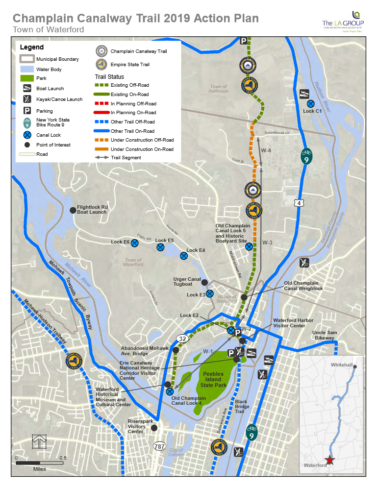
To Start from the Fulton Street/Mill Road parking area in Waterford [Southern Section]; Take I-787 north to Route 787 north to Route 32 (Saratoga Ave) across the Mohawk River into Waterford. Look to your right for a round Canalway Trail sign just past a retail plaza. Turn right here down Fulton St. Cross an iron bridge over the canal and turn right along the dirt Mill Rd. This will take you to a dirt parking lot next to the cement dam across the Mohawk River and the beginning of the Champlain Canalway Trail on your right.
To Start from the Brookwood Road parking lot in Halfmoon [Central Section]; From the intersection of Routes 4 & 32 in Waterford head north 3.6 miles along Routes 4 & 32. Turn left on Brookwood Rd, cross the RR tracks and turn left into the Halfmoon Treatment Facility where you'll find a parking lot on your right. A path will take you up to the trail.
To Start from the Upper Newtown Road in Halfmoon [Northern Section]; From the intersection of Routes 4 & 32 in Waterford head north 5.3 miles along Routes 4 & 32. Turn left on Upper Newtown Rd, cross over the RR tracks and you'll come to the parking lot on your left.
The Champlain Canalway Trail is a planned continuous trail from Waterford (where the Erie Canal departs from the Hudson River) North, to Whitehall. The modern day Champlain Canal follows the Hudson River North, to Fort Edwards where the man-made Champlain Canal branches away from the Hudson River towards Whitehall. In Fort Edwards the Feeder Canal Trail connects to the Champlain Canalway Trail. The original 25-foot-wide Old Champlain Canal was enlarged many times and the current Champlain Canal parallels the original Canal from Fort Edwards North, to Whitehall at the foot of Lake Champlain. The trail will mostly follow sections of the Old Champlain Canal. For more information visit; CANALWAY TRAIL , CHAMPLAIN CANALWAY TRAIL & 2022 CHAMPLAIN CANALWAY TRAIL GAPS .
I have broken the Champlain Canalway Trail into 3 Sections: Starting from Waterford & heading North, to Whitehall: Champlain Canalway Trail; Waterford-Mechanicville [Halfmoon to Mechanicville is all on-road], Champlain Canalway Trail; Mechanicville-Fort Edward [Schuylerville to Fort Edward is all on-road] and Champlain Canalway Trail; Fort Edward-Whitehall [Fort Ann to Whitehall is mostly all on-road].
The Champlain Canalway Trail is part of the Empire State Trail , which will be a continuous 750-mile route spanning the state from New York City North, to Canada and Buffalo East, to Albany, creating the longest multi-use state trail in the nation.
Champlain Canalway Trail; Waterford-Halfmoon Section:
Starting from the Fulton Street/Mill Road parking area in Waterford [Southern End]; To the South, spot the dam across the Mohawk River. To the East, are some rocky falls on the Mohawk River and Goat Island beyond them. To the West, is the Old Champlain Canal. Picnic tables located here as well. Look for the Old Champlain Canal Lock #4 with the wooden bridge crossing over it. The Champlain Canalway Trail starts here following the Old Champlain Canal Northeast, along its Eastern Bank, passing by the iron Fulton Street Bridge.
Note; If you cross the Fulton Street Bridge back to Saratoga Ave (Route 32) and travel left, South, on-road (sidewalk available) you'll cross a bridge over the Mohawk River and come to Route 787 after 0.7 miles. Left is the start of the Route 787 Path , a paved trail that travels South, along the Eastern Side of Route 787 for 1.1 miles to Dyke Ave. Here you may connect to the on-road portion of the Mohawk Hudson Bikeway .
Continuing Northeast, along the stone-dust Champlain Canalway Trail, it can be narrow at times as it travels through well shaded woodland. At 0.4 miles, you travel underneath the abandoned Mohawk Ave Bridge over the Canal. Cross O'Connor Drive at 0.5 miles. Here the towpath was rebuilt in 2021 to Burton Ave as part of a Superfund Site. Next come to where the Champlain Canal crosses the Erie Canal at 1 mile. There is no bridge over the Erie Canal to where the Champlain Canal continues, so you must turn right, Southeast, for a very scenic detour. This brings you to Lock 2, a working lock on the Erie Canal. If you’re lucky, you can watch the lock in action as it raises or lowers a boat in the lock. Continue on by taking the gravel path to the right of the Lock down to South St and travel straight. This brings you to the Point Park parking lot on your right.
Note; A stone-dust path leads down to an overlook of where the Erie Canal enters the Mohawk River. Across the Erie Canal is the Waterford Harbor Visitor Center.
Head left,
East, over the
Erie Canal
via the 4th Street
Bridge. Some great views from the bridge of the Locks massive gates, as well as,
views down stream of the Waterford Harbor Visitor Center and the
2nd Street Bridge over to Peebles Island State Park. Head down the winding, narrow
path to the brick lined Canal Walkway at
1.3 miles.
Note; Heading Southeast, along the Canal Walkway, alongside the Mohawk River, will take you to the Waterford Harbor Visitor Center. A Map Board is located here, as well as, restrooms and an info center. A small museum is located in the upper section, which you can access by going around the Visitor Center. If you continue along the Canal Walkway, it travels underneath the 2nd Street Bridge, before bringing you to Battery Point and the Waterford Boat Launch parking lot. This is where the Mohawk River enters the Hudson River after 0.2 miles. Map Board.
Note; Heading Southeast, along the Canal Walkway, alongside the Mohawk River, will take you underneath the 2nd Street Bridge to a Spur Trail on your left. This trail will take you up to 2nd St, where a pedestrian bridge will take you South, across the Erie Canal to Pebbles Island and the Black Bridge Trail .
Note; From the Waterford Harbor Visitor Center you can also access the Uncle Sam Bikeway located on the Eastern Side of the Hudson River in Troy.
Head right, Northwest, along the brick lined Canal Walkway traveling underneath the 4th Street Bridge to a stone-dust path alongside the Erie Canal. This will take you up alongside the Old Champlain Canal Sidecut Locks. These were Locks that were built to bypass the crowded urban ports along the main Canal. Two small bridges cross over this Sidecut to Lock 2. There are interpretive sign boards here as well. A parking lot is located at the top of the Sidecut, where the Old Champlain Canal picks up again. Follow the Canal right along the Lock 2 access road to the junction of 5th and Broad Streets. The trail continues across Broad St. A short paved section of trail continues North, along the Canal to a crosswalk over Division Street at 1.6 miles.
Note; From here you can take a side diversion to the Flight of Locks Trail (The Flight of Locks is the first five Locks (E2-E6) along the Erie Canal, although, this route only covers Locks 3-6. This sequence of Locks is the largest lift in the shortest distance, only 1.5 miles, of any system in the world). Head left, West, on-road along Division St all the way to 8th St and turn right. Turn left on Washington Ave and cross over the RR tracks. Come to the entrance for Lock 3 after 0.5 miles. After checking out Lock 3 continue North, past the Washington Ave parking lot where you'll pick up a narrow, stone-dust trail on your left. Picnic tables located here. This trail follows the Erie Canal and Fonda Rd up past the Fonda Road parking lot to Flightlock Rd at 0.9 miles. From here the trail travels on-road (low traffic) along the Canal up a sometimes steep grade. Pass by Locks 4-6 before passing by Guard Gates 1 & 2 where the road heads down to the Flightlock Road Boat Launch parking lot at 2.4 miles.
From Division Street, the wide trail reverts to stone-dust, as it follows the Canal. You'll pass an interpretive sign describing the former Champlain Canal Weigh Lock that used to be located here on the Canal. That's why the Canal briefly splits ahead. The trail travels underneath a railroad bridge at 1.8 miles and leaves the town behind. More isolated. A large marsh appears on your right. The Canal starts to choke up with vegetation at 2.4 miles as you travel underneath some transmission lines. Pass by Old Champlain Canal Lock #5. There is another interpretive sign here. Head up a short paved hill to the top of an old landfill where the stone-dust trail continues. Wide open views of the surrounding hills as you travel along the top of the grassy mound. After 3.2 miles you travel through a gate out to Clute Rd. Head right, then left along Bells Lane. Travel on-road (low traffic) up Bells Lane (the Old Champlain Canal is hidden on your left by a berm) and you'll pick up a short paved trail on your left that leads up to Schoolhouse Lane. Across Schoolhouse Lane you'll pick up the old towpath on your right at 3.7 miles. Here the stone-dust trail follows an open corridor. You then pick up the Old Champlain Canal again on your left. At 4.2 miles you'll come to the Halfmoon Section of the trail which is wide with a stone-dust surface. Cross Brookwood Rd at 5 miles.
Note; Just before Brookfield Road, a paved Spur Trail on your right, takes you East, to the Halfmoon Treatment Facility parking lot. The Halfmoon Lighthouse Park Spur then continues out to Brookwood Rd, where you briefly travel right across the RR tracks back to the paved trail which travels East, down to and across Route 4 to Halfmoon Lighthouse Park after 0.3 miles. Here you'll find a picnic pavilion, dock, river overlook and informational signs.
You'll quickly come to a sinkhole, where the Canal disappears. I believe this is Wilson's Culvert, a large culvert that allows Owl Creek to freely pass beneath the Old Champlain Canal. You cross Lower Newton Rd at 5.4 miles. After 6 miles you'll see some old stonework from the Canal. I believe this is remnants from the Old Champlain Canal Lock #7. Pass by an old bridge abutment at 6.5 miles. After 6.8 miles you come to the Upper Newtown Road parking lot in Halfmoon where the developed trail currently ends. As of 2024, the trail continues North, as a grass lined trail. I haven't checked it out. Funds have been secured to continue the trail North, however, it will be out & back.
Note; A GAP exists North, to the next section of the Champlain Canalway Trail in Stillwater.
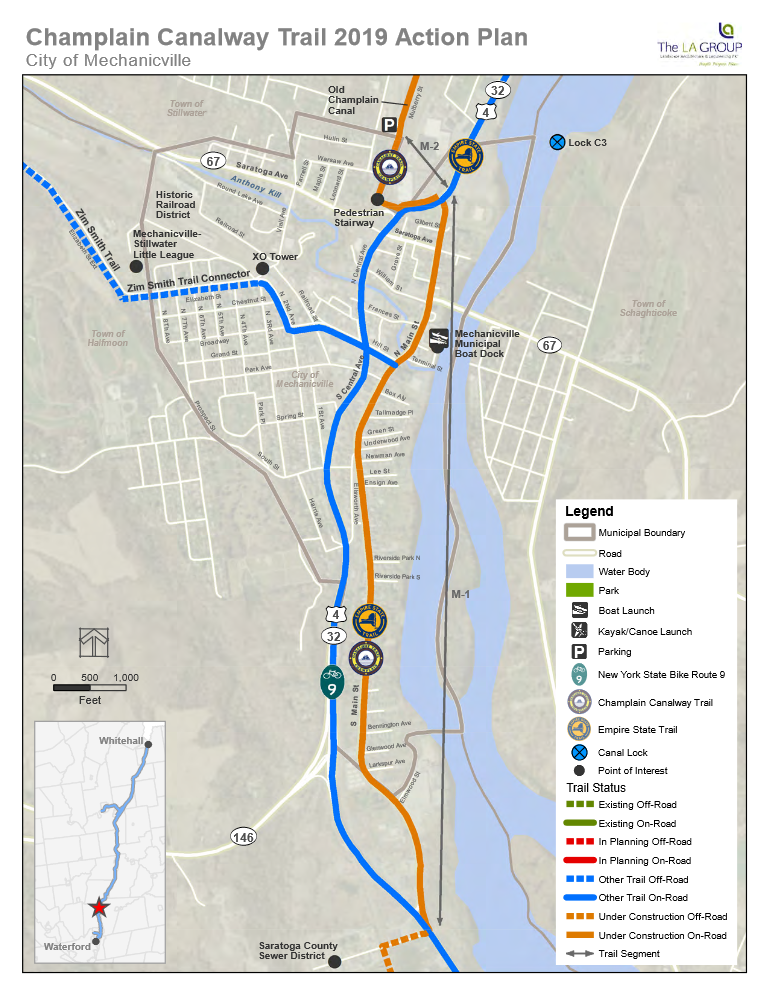
Champlain Canalway Trail; Halfmoon-Mechanicville Section:
From Halfmoon North, to Mechanicville the route is currently all on-road. See; Empire State Trail .
Note; See; Champlain Canalway Trail; Mechanicville-Fort Edward for next section.
CLICK HERE FOR CANALWAY TRAIL MAP
CLICK HERE FOR CHAMPLAIN CANALWAY TRAIL; WATERFORD SECTION MAP
CLICK HERE FOR CHAMPLAIN CANALWAY TRAIL; HALFMOON-MECHANICVILLE SECTION MAP
CLICK HERE FOR CHAMPLAIN CANALWAY TRAIL; MECHANICVILLE SECTION MAP
CLICK HERE FOR HALFMOON TRAILS MAP
CLICK HERE FOR COHOES AREA CANALS MAP
CLICK HERE FOR EMPIRE STATE TRAIL MAP
BEFORE YOU SET OUT BE SURE TO READ THE
WAIVER OF RESPONSIBILITY AND DISCLAIMER
BIKE IT OR HIKE IT