BEACON GREENWAY:
BEACON HUDSON RIVER TRAIL:
FISHKILL CREEK TRAIL:
DENNINGS POINT STATE PARK LOOP TRAIL:
BEACON, NEW YORK
-BIKE IT OR HIKE IT-
Last Updated: July 18, 2026
Length: Newburgh-Beacon Bridge Path; 2.1 miles
Beacon Hudson River Trail; 1.3 miles
Pete & Toshi Seeger Riverfront Park Loop; 0.3 mile Loop
Scenic Hudson's Long Dock Park Trails; 1 mile Loop
Dennings Point SP Loop Trail; 1.4 miles
Fishkill Creek Trail; 3.6 miles
Difficulty: Newburgh-Beacon Bridge Path; Have not checked it out yet.
Beacon Hudson River Trail; Easy. Flat, hard packed gravel, stone-dust and paved trail with some short on-road sections.
Pete & Toshi Seeger Riverfront Park Loop; Easy. Narrow crushed gravel Loop trail.
Scenic Hudson's Long Dock Park Trails; Easy. Stone-dust trails.
Dennings Point SP Loop Trail; Moderate. Relatively flat, hard packed dirt trail. Some sections contain tree roots. Mt. bike recommended.
Fishkill Creek Trail; Easy. Hard packed gravel, stone-dust & paved trail. Some small hills. On-road section.
Directions:
To Start from the Pete & Toshi Seeger Riverfront Park parking lot for the Beacon Hudson River Trail [Northern End]; From I-84 take exit 41 to Route 9D south and travel 0.7 miles. Turn right on Beekman St, then turn right, across a bridge over the RR tracks. Straight leads to the Scenic Hudson's Long Dock parking lot. Head right and the road north to the Pete & Toshi Seeger Riverfront Park parking lot.
To Start from the Dennings Ave parking lot for the Beacon Hudson River Trail [Southern End] & Dennings Point SP Loop Trail & Fishkill Creek Trail [Southwestern End]; From I-84 take exit 41 to Route 9D south and travel 1.3 miles. Turn right on Hudson Ave, then bear right on Dennings Ave. Follow to the parking area next to the sewage treatment plant.
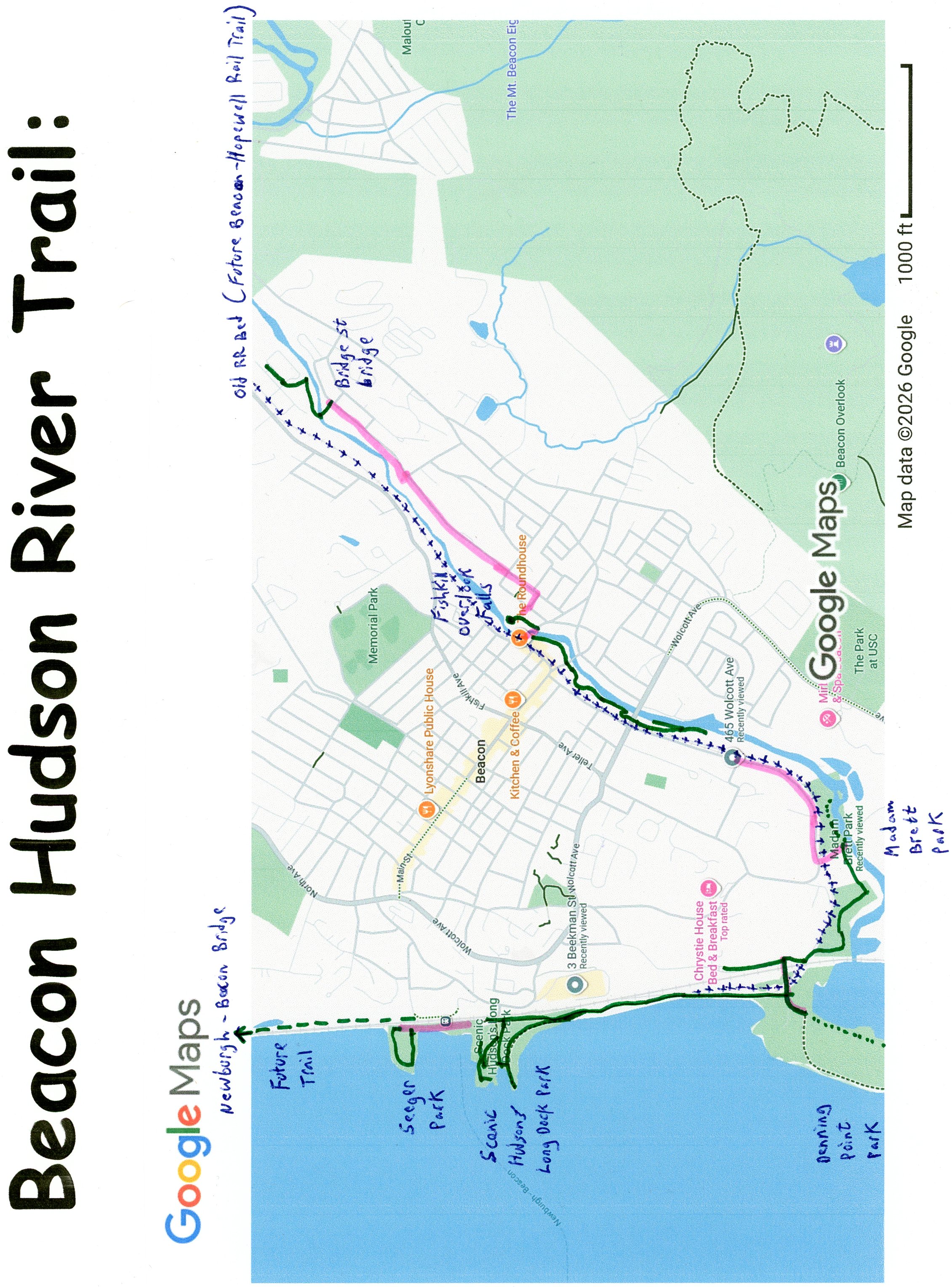
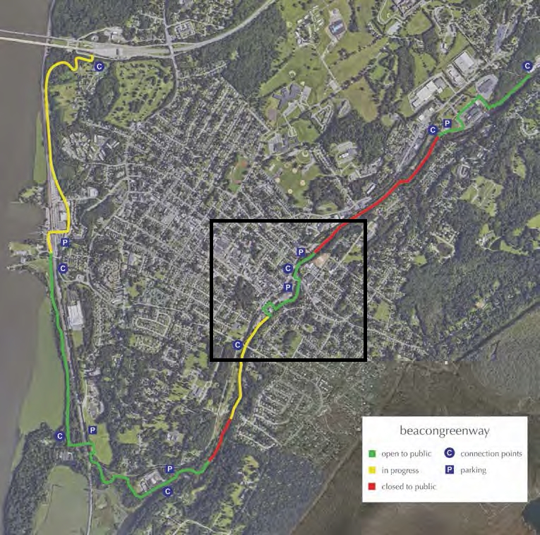
The town of Beacon has proposed the Beacon Greenway, a trail starting from the end of the Newburgh-Beacon Bridge Path (Path crosses the Hudson River from Newburgh East, 2.1 miles to Beacon) that will travel West, down to the Hudson River. Here it will travel North, underneath the Newburgh-Beacon Bridge a short distance (not sure if the plan is to connect to a 0.6 mile paved trail further North, between the RR tracks and a housing development in West Fishkill) as well as, South, alongside the river to the Beacon Metro-North Train Station, where you'll connect to the completed Beacon Hudson River Trail. See; Map Below.
From the Beacon Metro-North Train Station the trail will either cross over the RR tracks via a bridge or the Long Dock Road bridge to Scenic Hudson's Long Dock Park. Here the trail travels North, on-road to the Pete & Toshi Seeger Riverfront Park, where you'll find a Loop Trail. Heading South, the Beacon Hudson River Trail, also referred to as the Klara Sauer Trail & Riverfront Trail, travels underneath Long Dock Rd. Here, you can access the trails around Scenic Hudson's Long Dock Park, which also connect back into the Beacon Hudson River Trail. The trail continues South, between the RR tracks and Hudson River to Dennings Ave. From here you can access the Dennings Point SP Loop Trail South, in Dennings Point State Park [Note; This trail is closed from Dec. 01 -March 31], as well as, the Beacon Hudson River Trail; Fishkill Creek Trail to the East. The Fishkill Creek Trail includes the short, paved Dave Miller Connector Trail, which gets you past two RR crossings and connects to the Madam Brett Park Trails, located at the confluence of Fishkill Bay/Creek. The Fishkill Creek Trail continues Northeast, along Fishkill Creek up to Fishkill. This trail is still a work in progress with on-road GAPS. The Beacon Hudson River Trail would also be part of the regional HUDSON RIVER VALLEY GREENWAY . See; BEACON HUDSON RIVER TRAIL PLAN .
The Hudson Highlands Fjord Trail is a planned 9 mile trail linking Cold Spring's Metro-North Train Station North, to the Beacon Metro-North Train Station. The Beacon Hudson River Trail is part of this larger trail system. For more information visit; HUDSON HIGHLANDS FJORD TRAIL .
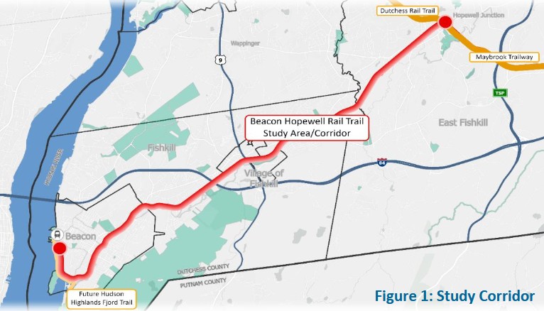
The Beacon-Hopewell Rail Trail is a planned trail that will follow the inactive MTA’s Beacon RR Line, that splits off the active METRO NORTH RR tracks just South of the Beacon Metro-North Train Station. It would start from the Beacon Train Station and follow the current Beacon Hudson River Trail, which travels alongside part of the old rail bed, South, to Dennings Ave. Here the old rail bed separates from the Beacon Hudson River Trail and turns East, crossing over the active Metro North RR tracks, before turning Northeast, through Fishkill to the hamlet of Hopewell Junction in the Town of East Fishkill. Here it would connect to the both the Dutchess Rail Trail & Maybrook Trailway . See; Beacon-Hopewell Rail Trail .
Newburgh-Beacon Bridge Path:
Starting from the Grand Ave parking lot in Newburgh; I have not checked out this trail. Exit the parking lot and travel South, along the wide, paved Newburgh-Beacon Bridge Path, underneath I-84. Map Board below the overpass. The trail then takes you up to and alongside I-84 Eastbound. Path crosses the Hudson River to Beacon, exiting right to Newburgh Beacon Way (Restricted traffic) at 1.7 miles.
Note; Future construction of the Beacon Hudson River Trail will take it West, down to the Hudson River. Here it will travel North, underneath the Newburgh-Beacon Bridge a short distance (not sure if the plan is to connect to a 0.6 mile paved trail further North, between the RR tracks and a housing development in West Fishkill), as well as, South, alongside the river to the Beacon Metro-North Train Station, where it will connect to the completed Beacon Hudson River Trail. See; Map Above.
Continue East, where the trail follows road past the Newburgh-Beacon Bridge Toll Gantry, then out to Route 9D after 2.1 miles.
Beacon Greenway:
Beacon Hudson River Trail:
Starting from the Pete & Toshi Seeger Riverfront Park parking lot [Northern End]; Sports courts. Porto-Potty.
Note; The narrow, 0.3 mile crushed gravel Pete & Toshi Seeger Riverfront Park Loop circles this small park alongside the river. Good view of the Newburgh-Beacon Bridge to your North.
Travel South, on-road, along Red Flynn Dr (low traffic) and you'll come to a *brick lined path.
Note; Right leads to the NEWBURGH-BEACON FERRY dock. Left leads to the Beacon RR Station. See; METRO NORTH RR .
Straight leads to Red Flynn Rd which crosses over the RR tracks. Instead bare left, through a parking lot to the end where you'll pick up the narrow, stone-dust Beacon Hudson River Trail which travels underneath Long Dock Rd to an intersection at 0.3 miles.
Note; Right, takes you to LONG DOCK PARK . Travel West, along the wide, stone-dust Scenic Hudson's Long Dock Park Trail, past fields to a **Kayak Pavilion next to the Hudson River. Head right, past the pavilion, then left, along a boardwalk and right along a wide cement plaza to a picnic pavilion. Head left, along the closed road to a promenade overlooking of the river. A stone-dust trail then travels East, to another intersection.
Note; Left, a stone-dust trail travels East, before quickly ending. Not sure if future plans will continue this trail back to the *brick lined path by the Newburgh-Beacon Ferry.
Continue straight, where the trail takes you out to Long Dock Road. Parking located here. Left leads to the red Scenic Hudson's River Center. Cross the road where a narrow stone-dust trail leads to an intersection. A wide, stone-dust trail will take you right, back to the picnic pavilion. Head left, along a wide cement plaza back past the **Kayak Pavilion. Head right, West, along a boardwalk to an overlook, then back East, along the wide, stone-dust trail. The trail turns South, bringing you to the ***Intersection of the paved Beacon Hudson River Trail after a 1 mile Loop.
The paved Beacon Hudson River Trail (Klara Sauer Trail/Riverfront Trail) continues South, between Scenic Hudson's Long Dock Park & Metro-North RR tracks. Pass by an ***Intersection on your right at 0.5 miles.
Note; The stone-dust Scenic Hudson's Long Dock Park Trail joins you along your right.
Next, come alongside the inactive MTA’s Beacon RR Line at 0.8 miles. The trail continues alongside the Hudson River, before leaving the river and old rail bed behind.
Note; The proposed Beacon-Hopewell Rail Trail would utilize the old rail bed from here heading East, then North, to Fishkill. See; Beacon-Hopewell Rail Trail .
Come to Dennings Ave at 1.2 miles.
Note; Right, the old gravel Dennings Ave leads to the Dennings Point Loop Trail. See; Below.
Continue left, East, along the old gravel Dennings Ave, crossing a bridge over the inactive Metropolitan Transportation Authority’s Beacon Line, followed by a bridge over the Metro North RR Line to the ^Dennings Ave Intersection at 1.3 miles. Map Board.
Note; Left, the old gravel Dennings Ave travels North, bringing you to the Dennings Ave parking lot after 0.2 miles.
Fishkill Creek Trail:
From the ^Dennings Ave Intersection & Map Board; [Continuing Mileage; 1.3 miles] Continue South, along the paved Dave Miller Connector Trail. The trail travels down alongside the Metro-North RR Line, taking you underneath the old Beacon Line RR bridge, then heading up into the woods. After 0.2 miles, the trail turns to hard packed gravel as you enter Madam Brett Park. The Fishkill Creek Trail [Madam Brett Park Trail] takes you East, past an overlook of Fishkill Bay. Some small hills take you past an intersection on your left, to a boardwalk that travels above Fishkill Creek and alongside an old brick building. Cross South Ave to Madam Brett Park parking lot, where you'll find an Map Board overlooking the creek at [1.9 miles].
Note; The gravel trail continues North, alongside the creek, bringing you to an overlook of Sucker Falls Dam after 2 miles.
Note; A GAP exists Northeast, to the next section, as of 2025.
Detour; To reach the next section follow South Ave from Madam Brett Park parking lot to Tioronda Ave and head right, North, on-road (low traffic). After 0.6 miles [2.5 miles] turn right on Arno Dr to a parking lot and continue North, through the lot to the apartment buildings. I have not checked out this section. Pick up the crushed gravel Fishkill Creek Trail on your right.
Note; Not sure if this trail also travels South, alongside the parking lot.
The trail travels between the buildings and Fishkill Creek below. Pass an overlook for a dam and come to an intersection.
Note; Right leads to an overlook of the river and a dead end.
Continue straight up to Wolcott Ave and head left, along the sidewalk back to Tioronda Ave and cross Wolcott Ave. Then right, back along Wolcott Ave. Rejoin the trail on your left. I believe the crushed gravel trail winds down to the river, then continues North, along the river to a business building. I'm not sure if the trail continues behind this building and above the river. If not, utilize the drive past this building and you'll pick up the trail on your right, where it passes through the parking lot. I've checked out this next section. The crushed gravel trail continues between another building and the river to Churchhill St. Cross the street and continue past a Map Board along the creek. Pass by the Hudson Valley Brewery and come to E Main St. Head right, on-road (sidewalk available) across Sauers Bridge. Look upstream to view the Fishkill Overlook Falls. Turn left, after crossing the bridge and follow the cement sidewalk North, along the entrance for the Roundhouse. A narrow sidewalk bears left, bringing you to a spacious overlook of Fishkill Overlook Falls after 3.6 miles. I have not checked out this overlook.
Note; A GAP exists, as of 2025, to the next section.
Detour; [Re-zeroing Mileage] Return to the Roundhouse entrance road and continue left, past the converted old brick mill buildings. Turn right and travel out and across Leonard St to Amity St. This brings you to Liberty St. Head left, North, on-road (low traffic/sidewalk available) and follow to Bridge St. Head left along Bridge St back to Fishkill Creek. Cross the Historic cast iron bridge (no vehicles allowed) to an open area. Turn right and you'll pick up the Fishkill Creek Trail on your right after 1.1 miles.
[Re-zeroing Mileage] The narrow, stone-dust Fishkill Creek Trail continues Northeast, alongside Fishkill Creek (very scenic) for a short distance, before turning left, North, inland. It then turns right, up to Front St, where it travels Northeast, past the Lofts at Beacon (converted old mill) on your right, ending after 0.4 miles next to Building 4.
Dennings Point SP Loop Trail:
Starting from the Dennings Ave parking lot; Travel South, past the black gate along the old gravel Dennings Ave and you'll come to an intersection at 0.2 miles. Heading right, West, you'll cross a bridge over the active Metro North RR tracks and then cross a set of inactive RR tracks. This brings you to an**Intersection with the Beacon Hudson River Trail [Klara Sauer Trail], at 0.3 miles. [Re-zeroing mileage] Continue straight to another intersection.
Note; Straight will bring you to the Beacon Institute for Rivers & Estuaries Visitor Center. Restrooms available.
Head left, South, along the Dennings Point SP Loop Trail and you'll come to a Map Board. Head right along the narrow, hard packed dirt trail into the woods. Quickly come to an intersection and head right up a slight incline. Some rocks and tree roots but very ridable. You travel above the river, which is mostly blocked by the tree cover, along the Western Side of the park. After about 0.7 miles the trail Loops back North, alongside Fishkill Bay, via the Eastern Side of the park. This section of trail is less developed with many more tree roots and some muddy sections. You return to the intersection and head right back to the Map Board. Return to the intersection with the Beacon Hudson River Trail [Klara Sauer Trail] after a 1.4 mile Loop.
HH
CLICK HERE FOR BEACON RIVERFRONT TRAIL & DENNINGS POINT SP LOOP TRAIL 2019 MAP
CLICK HERE FOR BEACON GREENWAY & FISHKILL CREEK TRAIL MAP
CLICK HERE FOR BEACON GREENWAY & FISHKILL CREEK TRAIL 2018 MAP
CLICK HERE FOR BEACON GREENWAY & FISHKILL CREEK TRAIL 2013 MAP
CLICK HERE FOR MADAM BRETT PARK TRAIL MAP
CLICK HERE FOR HUDSON HIGHLANDS FJORD MAP
CLICK HERE FOR BEACON-HOPEWELL RAIL TRAIL MAP
BEFORE YOU SET OUT BE SURE TO READ THE
WAIVER OF RESPONSIBILITY AND DISCLAIMER
BIKE IT OR HIKE IT