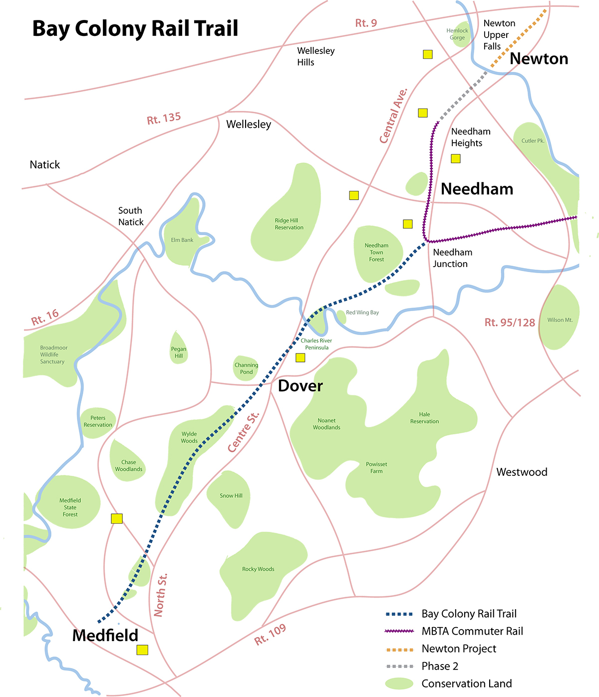
BAY COLONY RAIL TRAIL:
UPPER FALLS GREENWAY:
NEWTON UPPER FALLS, MASSACHUSETTS
NEEDHAM RAIL TRAIL:
NEEDHAM, MASSACHUSETTS
DOVER GREENWAY:
DOVER, MASSACHUSETTS
MEDFIELD RAIL TRAIL:
MEDFIELD, MASSACHUSETTS
-BIKE IT OR HIKE IT-
The Bay Colony Rail Trail is a proposed multi-use trail along the old rail bed of the former Bay Colony RR. Starting from Newton Upper Falls, the Upper Falls Greenway travels Southwest, along the old rail bed. There is a Gap in Needham, until Needham Junction where the Needham Rail Trail continues Southwest, along the old rail bed. Another Gap in Dover, where the proposed Dover Greenway has yet to be built. Further Southwest, is the Medfield Rail Trail. For more information visit; BAY COLONY RAIL TRAIL .
UPPER FALLS GREENWAY:
Last Updated: August 25, 2025
Length: Upper Falls Greenway; 1 mile
Difficulty: Easy. Flat stone-dust rail trail.
Directions:
To Start from the Easy Street parking lot in Newton [Northern End]; From I-95 take exit 36A to Route 9 in Newton. After 1.4 miles exit to Boylston St, then head left (south) on Winchester St. Bare right on Needham St and a quick right on Easy St. Parking straight ahead, behind which is the rail trail.
To Start from the Chestnut Street parking lot in Newton [Southern End]; From Route 9 in Newton exit to Boylston St, then head left (south) on Winchester St. Bear right on Needham St and follow for 0.7 miles to Oak St. Turn right, cross over the trail, then turn right on Chestnut St. Parking lot is on your right. This is a metered lot.
The Upper Falls Greenway follows the former rail bed of the Bay Colony RR. For more information visit; NEWTON CONSERVATORS; UPPER FALLS GREENWAY .
Starting from the Easy Street parking lot [Northern End]; The Upper Falls Greenway begins at the Northern End of the parking lot. A Map Board is located at the Southern End of the parking lot.
Note; Future plans will extend the trail North, 0.3 miles, to Curtis St.
The wide, stone-dust Upper Falls Greenway travels Southwest, along the old rail bed along a wooded corridor. After 0.4 miles you'll come to a Map Board located next to a super tall antenna.
Note; On your left, an old RR Spur takes you 0.2 miles East, out to Needham St. Informational signs along this trail. Parking located along this Spur.
Continuing Southwest, you'll pass by a bocce court, picnic tables & Map Board, located next to the Chestnut Street parking lot. Next pass by the old 1852 Newton Upper Falls Depot, before crossing Oak St at 0.7 miles. Look for an old RR Semaphore on your right, just before a berm takes you to an old RR bridge over the Charles River. + See; RR Signal Below. Another super tall antenna on your right, along with an old granite RR Whistle Post. + See; RR Whistle Post Below. The trail currently ends here after 1 mile. Unfortunately on the other side of the river, the old RR bridge that would get you over I-95 is gone, so I'm not sure if there are future plans to continue the trail South, into Needham. Some steep stairs here lead down to the Charles River Upper Falls Riverwalk.
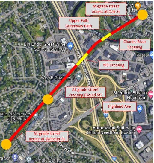
The City of Newton and Town of Needham are working together to study the future use of the former railroad corridor that historically connected the two communities. Recreating a connection is a long-term interest and effort. The possibility of a shared-use path would extend the Upper Falls Greenway South, across the Charles River, across I-95/128, and along the former railroad right of way to Webster St in Needham Heights. This project is still in the preliminary stages. See; Map Below.
NEEDHAM RAIL TRAIL:
Last Updated: August 25, 2025
Length: Needham Rail Trail; 1.5 miles
Difficulty: Easy. Flat stone-dust rail trail.
Directions:
To Start from the Fisher Street parking lot in Needham [Southern End]; From I-95 take exit 32 to West St west. Cross the river and turn left on South St. After 2.5 miles turn right on Fisher St. Cross the trail turn right into the parking lot.
The Needham Rail Trail follows the former rail bed of the Bay Colony RR Northeast. For more information visit; BAY COLONY RAIL TRAIL; NEEDHAM
Starting from Fisher Street parking lot [Southern End]; Hiking trails and canoe launch for the Charles River located across the street in Redwing Bay.
Heading West; The stone-dust Needham Rail Trail travels above the Charles River and Charles River Peninsula, along a wooded corridor. You pass by an old cement RR Whistle Post on your left. + See; RR Whistle Post Below. Come to an old RR bridge over the Charles River after 0.3 miles. The trail currently ends here at the Dover town line. If you look right, up the river you can spot a 3 arch stone bridge (Centre St).
Heading Northeast; The stone-dust Needham Rail Trail follows the old rail bed along an open wooded corridor. Cross Charles River St, followed by wood fencing and look left to spot an old cement RR Whistle Post. Enter the woods at 0.7 miles and pass through several small rock cuts before you cross a high berm. Pass by a Spur Trail on your left at 1 mile. This leads to High Rock. The trail then currently ends after 1.2 miles short of High Rock St. RR tracks still here.
DOVER GREENWAY:
Last Updated: August 25, 2025
Length: Dover Greenway;
Difficulty: Rail trail.
Directions:
The Dover Greenway will follow the former rail bed of the Bay Colony RR North-South. For more information visit; DOVER GREENWAY .
This trail is under design review in 2025.
MEDFIELD RAIL TRAIL:
Last Updated: August 25, 2025
Length: Medfield Rail Trail; 1.5 miles
Difficulty: Easy. Flat stone-dust rail trail.
Directions:
To start from the Ice House Road parking lot in Medfield [Southern End]; From I-495 take exit 46 to Route 126 north. Continue along Route 109 to Medfield. Turn left on Route 27 and follow for less than a mile. Turn right on W St, then left on W Mill St. Take your first left on Ice House Rd. Parking lot on your left.
The Medfield Rail Trail follows the former rail bed of the Bay Colony RR North-South. For more information visit; MEDFIELD RAIL TRAIL .
Starting from the Ice House Road parking lot [Southern End]; The old rail bed still has old RR tracks in place, as it disappears into the woods heading West, where it merges with an active RR. Cross Ice House Rd where the wide, stone-dust Medfield Rail Trail travels North, along an open wooded corridor. Cross Harding St into the woods. Travel past the North Brook Marsh along a causeway. Re-enter the woods at 0.4 miles and pass by an old cement RR Whistle Post on your left. + See; RR Whistle Post Below. Another old cement RR Whistle Post at 0.7 miles. Cross Farm Street at 1 mile. Parking located here. Trail ends after 1.3 miles at the Dover town line. Old RR tracks still in place.
Old Railroad Equipment:
+
RR Whistle Post:
The Whistle Post,
was a post with a large "W" engraved or painted on it. This
meant the railroad engineers were to start sounding the trains Whistle.
The Whistle posts
were usually placed 0.25 miles
in advance of a road crossing,
bridges, tunnels and other points. Usually, there would be a post placed
on both sides of the crossing, covering both directions.
+ RR Signal:
Railroad
Signals direct the engineman on how to proceed. They are categorized into
two levels: Permissive and Absolute. Permissive signals alert train operators
there is an obstruction on the tracks ahead. They are considered
“permissive” because their function is to protect. After the stop, they can
continue forward at a slower speed, commonly referred to as the “restricted
speed.” An absolute signal occurs at any point of the track where there’s an
interruption. They are considered “absolute” because their function is to
control. When a train reaches the absolute signal, it must come to a complete
stop and stay stopped until the signal indicates it’s safe to proceed. There
are different types of Railroad Signals. Semaphores consist of blades,
set to different positions, while Light Signals use different color
lights/number combinations.
HH
CLICK HERE FOR BAY COLONY RAIL TRAIL MAP
CLICK HERE FOR MEDFIELD RAIL TRAIL MAP
BEFORE YOU SET OUT BE SURE TO READ THE