ASHUWILLTICOOK RAIL TRAIL:
ADAMS-LANESBORO, MASSACHUSETTS
-BIKE IT OR HIKE IT-
Last Updated: September 05, 2025
Length: Ashuwillticook Rail Trail; 13.6 miles.
Difficulty: Easy. Flat, paved rail trail.
Directions:
To start from the Merrill Ave (Route 9) parking lot in Pittsfield [Southern End]; From the Routes 7 & 9 junction in Pittsfield. Follow Route 9 east for 2.8 miles. Parking lot on your left.
To start from the US 7/Route 8 Connector Road parking lots in Lanesborough [Southern End]; From the Routes 8 & 9 junction in Pittsfield. Travel north along Route 8 and you'll come to the Route 7-Route 8 Connector Rd on your left. Turn left and the Route 7-Route 8 Connector Road parking lots are located on both sides of the road.
To start from the Visitor Center in Adams [Northern End]; From the Routes 7 & 9 junction in Pittsfield, continue north on Route 7 for 3.7 miles and turn right onto the US 7/Route 8 Connector Rd. This brings you to Route 8. head left (north) along Route 8. After you cross the Hoosic River into downtown Adams. Travel another 0.3 miles Hoosac St and turn right. Take an immediate right on Depot St, The Visitor Center is on your left.
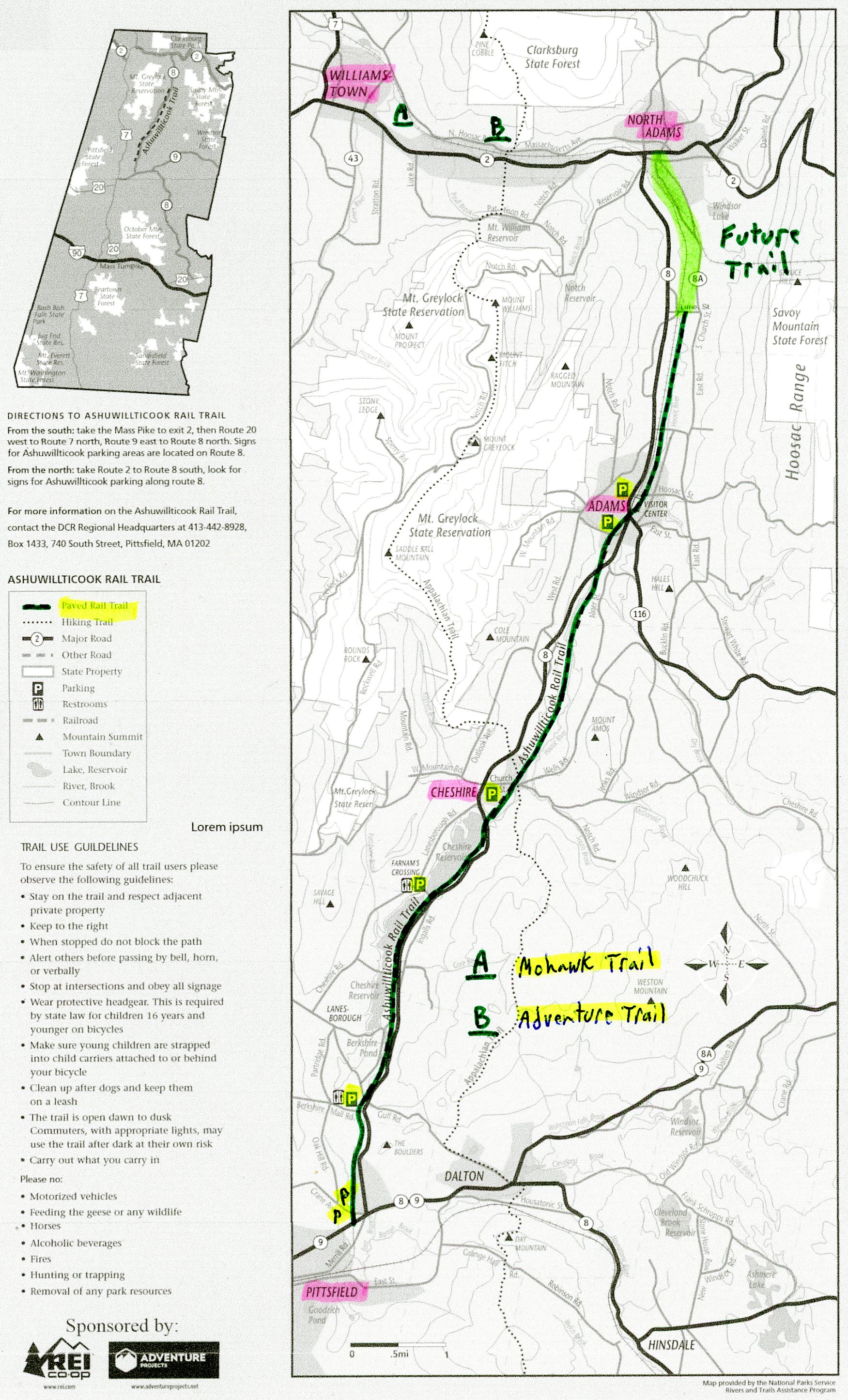
In 1845, the Pittsfield & North Adams Railroad developed this corridor, but was acquired by the Western Railroad during construction. In 1867, the name changed to the Boston & Albany Railroad. The New York Central took over in 1900 and then became part of Penn-Central (later Conrail) in 1970. Finally the line was sold to the Boston & Maine Railroad in 1981 and was abandoned in 1990. The Ashuwillticook Rail Trail travels North, from Pittsfield and passes through Lanesborough, Cheshire & Adams. The trail also passes through the Hoosac River Valley, between Mt. Greylock and the Hoosac Mountains. Cheshire Reservoir, the Hoosac River and associated wetland communities flank much of the trail. Future construction will extend the trail North, to North Adams, where it will connect to the planned East-West, Adventure Trail. See; Mohawk Trail . For more information visit; ASHUWILLTICOOK RAIL TRAIL .
Starting from the Merrill Ave (Route 9) parking lot in Pittsfield [Southern End]; Map Board.
Note; The old rail bed continues across the road, however, it leads to a rail yard & joins an active line. The next section South, will utilize a shared-use path along Merrill Ave (Route 9) for 1.5 miles and is slated to start construction in 2027.
The wide, paved Ashuwillticook Rail Trail travels North, traveling underneath Dalton Ave, before coming to the Crane Ave parking lot at 0.4 miles. BIKE STATION & restrooms located here. The trail crosses Crane Ave and follows an open corridor through the wetlands of Unkamet Brook. You detour off the old rail bed at 1.5 miles to avoid an industrial site. Trail loops around to Route 8 and continues North, before heading back to the old rail bed and the 1st of two parking lots off US 7/Route 8 Connector Road at 2 miles. Cross the road, past the 2nd parking lot, where you'll find a Map Board & restrooms, as you enter Lanesborough.
Note; A paved Spur Trail follows the US 7/Route 8 Connector Rd West, up to the Berkshire Mall.
The trail parallels Route 8, but is generally isolated from the traffic noise. The grade is flat with just a slight descent until you cross into Adams where the grade is a bit steeper. You parallel the Hoosic River all the way to Adams, but won't always see the river. Pass by Berkshire Pond, then cross Old State Rd at 3.4 miles. At 3.7 miles, you'll pass one of many old cement RR Whistle Post. + See; RR Whistle Post Below. You now cross into Cheshire. At 4.4 miles you come alongside the Cheshire Reservoir where you'll find benches, picnic tables and informational signs along its shoreline. At 5.3 miles, you cross Farnam's Rd, where a causeway crosses the reservoir. Map Board here. Cheshire Reservoir parking lot located west just up Farnam's Rd. A cross light gets you safely over Route 8 at 6.8 miles. Route 8 parking lot to your left along with a Map Board. Cross a small bridge over Kitchen Brook. Pass by what I believe to be the old Cheshire Depot on your left, followed by the 1st of two Railroad Street parking lots before crossing Church & Main St at 7.5 miles. Pass by the 2nd Railroad Street parking lot.
Note; The Appalachian Trail uses Church St on its journey up Mt. Greylock.
This next section is highlighted by the Hoosic River wetlands, as the trail travels along a causeway. Head back into woods and cross a bridge over the Hoosic River and Harbor Rd at 9.9 miles. This next section is very scenic as you follow the Hoosic River past a dam through a narrow gorge alongside a ridge. The trail is more downhill until it reaches Adams. Cross into Adams at 10.2 miles. Travel underneath Grove St, followed by a bridge over the river at 11.3 miles. Follow a deep cut and travel underneath Elm St. Just before crossing Harmony St look right to spot the old elevated RR Siding. Pass by the Russell Street Field parking lot at 11.8 miles. Great view of Mt. Greylock and its observation tower from here. The trail comes alongside the Hoosic River and crosses Park St (Route 8) at 12.1 miles as you enter downtown Adams. Another parking lot located here on your left.
Note; A BIKE LANE travels left, through downtown Adams. If you have time, take a quick detour downtown to see the beautifully renovated mill buildings and the old Armory.
You'll pass by the old Adams RR Station, now a pub, before passing a pocket park on your right and the Adams Visitors Center (Restrooms, Maps, picnic table and parking) on your left and coming to Hoosac St at 12.5 miles. Cross Hoosac St and Adams Station Park will be on your right (restrooms). This serves as a station for the HOOSAC VALLEY TRAIN RIDE , a scenic train ride between Adams and North Adams. Continue North, between the RR tracks and river.
Note; A Spur Trail on your left crosses the RR tracks brining you to Memorial Park.
Up on the hills are a series of wind turbines. Pass by a pedestrian over the river that leads to Murray St. Cross Cook St (spot the old RR grain silos on your right) where you veer away from the RR tracks and rail bed back alongside the river. Come to Lime St after 13.6 miles and the current end of the trail.
Note; Future plans call for continuing the trail North, 1.8 miles to Hodges Cross Rd in North Adams, starting construction in Spring 2028.
Old Railroad Equipment:
+
RR Whistle Post:
The Whistle Post,
was a post with a large "W" engraved or painted on it. This
meant the railroad engineers were to start sounding the trains Whistle.
The Whistle posts
were usually placed 0.25 miles
in advance of a road crossing,
bridges, tunnels and other points. Usually, there would be a post placed on both
sides of the crossing, covering both directions.
HH
CLICK HERE FOR ASHUWILLTICOOK RAIL TRAIL BROCHURE MAP
CLICK HERE FOR ASHUWILLTICOOK RAIL TRAIL MAP
BEFORE YOU SET OUT BE SURE TO READ THE
WAIVER OF RESPONSIBILITY AND DISCLAIMER
BIKE IT OR HIKE IT