AIRPORT PARK TRAIL:
ALBANY LOOP TRAIL:
ALBANY COUNTY, NEW YORK
-BIKE IT OR HIKE IT-
Last Updated: July 09, 2026
Length: British American Blvd & Cornell Road BIKE LANES; 1.1 miles
Airport Park Trail; 1.3 miles
Albany Loop Trail; Route 155 Bike Path; 1.1 miles
Albany Loop Trail; Watervliet Shaker Road Bike Path; 0.8 miles
Difficulty: Airport Park Trail; Easy. Mostly flat paved trail. One slight hill.
Albany Loop Trail; Route 155 Bike Path; Easy. Mostly flat paved trail.
Albany Loop Trail; Easy. Mostly flat paved trail.
Directions:
Starting from Route 7 in Latham [Northern End]; From I-87, take exit 6 to Route 7 W. Travel 2.8 miles to British American Blvd and turn left. Just past the Wendy's on your right is a parking lot.
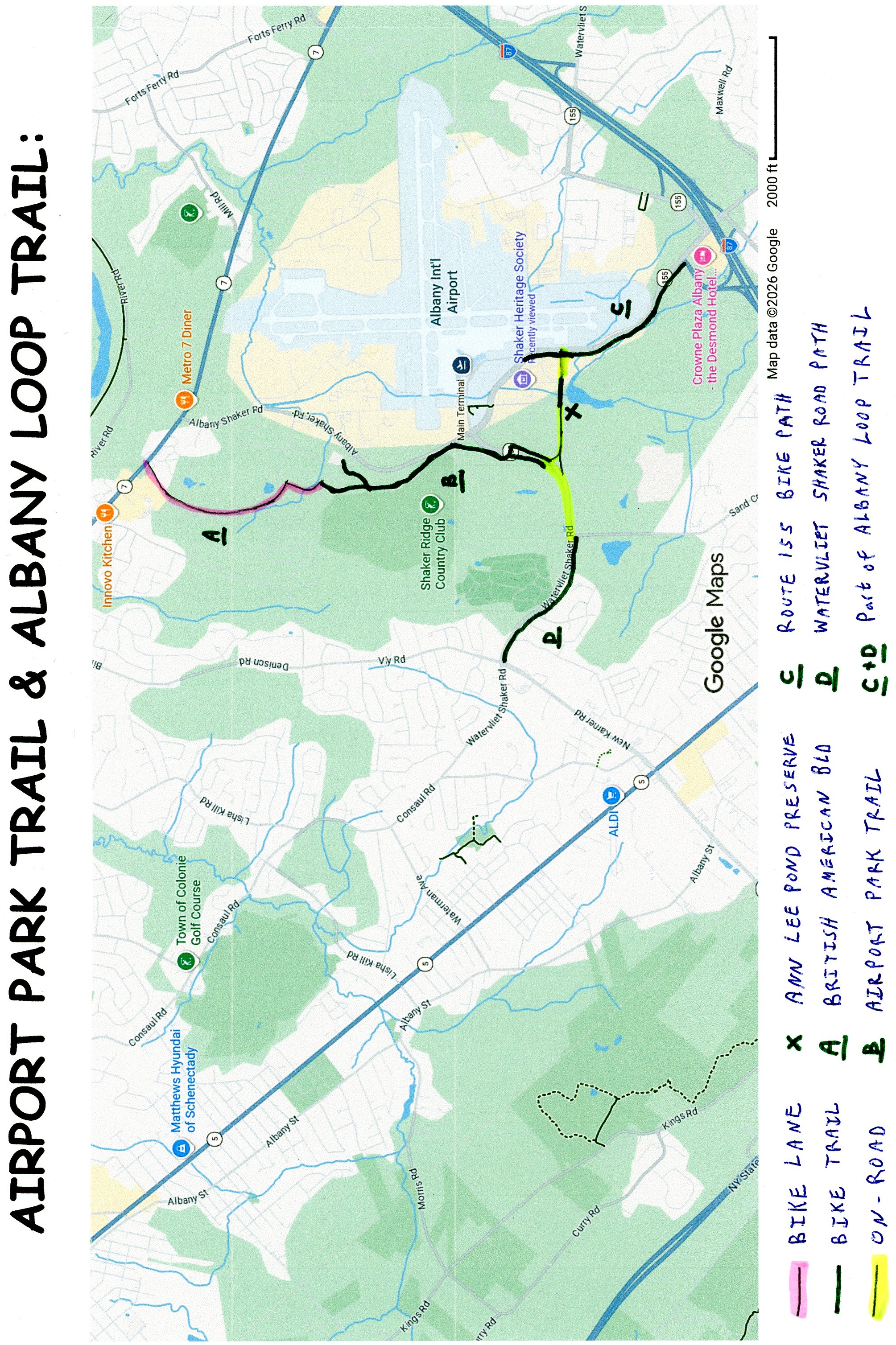
The British American Blvd BIKE LANE travels South, from Route 7 in Latham (part of Colonie), through Airport Park (business park), connecting to the Cornell Road BIKE LANE, which then connects to the Airport Park Trail. This paved trail continues South, through the woods, before briefly passing the end of a runway, for Albany International Airport. It then travels alongside Watervliet Shaker Rd (Route 155) to **Airline Drive. Here, you'll connect to the proposed Albany Loop Trail.
The proposed Albany Loop Trail will begin from the Albany County Helderberg-Hudson Rail Trail in Voorheesville (which travels East, to Albany) and travel Northeast, alongside Route 155 to Watervliet Shaker Rd. Here it will continue East, alongside Watervliet Shaker Rd to **Airline Drive, where it connects to the Airport Park Trail. It will then continue East, past the ANN LEE POND NATURE PRESERVE . Finally it will travel Southeast, alongside Route 155, where it will connect to the Crossings of Colonie Trails in Colonie.
British American Blvd BIKE LANE-Cornell Road BIKE LANE & Airport Park Trail:
Starting from Route 7 in Latham [Northern End]; The British American Blvd BIKE LANE travels South, along this low traffic road. Enter the business park and come to Cornell Rd at 0.9 miles. Turn right, along the Cornell Road BIKE LANE and you'll pick up the Colonie Airport Park Trail, just before the road ends, on your right after 1.1 miles. The wide paved Colonie Airport Park Trail travels past the business park and into the woods. Pass by a Spur Trail on your left at 1.3 miles.
Note; This paved Spur Trail takes you out to Airport Park Blvd.
A slight hill takes you out alongside Albany Shaker Rd at 1.7 miles. A runway for Albany International Airport is across the road. You head back into the woods and come to an intersection and *Bridge at 2.1 miles.
Note; Right, the Colonie Airport Park Trail travels South, along the Western Side of Watervliet Shaker Rd (Route 155) to Airline Dr. I Looped back via this trail.
Continue straight across the *Bridge over Watervliet Shaker Rd ( Route 155), where the trail travels South, along the Eastern Side of Watervliet Shaker Rd ( Route 155) to **Airline Drive after 2.4 miles.
Note; A crosswalk takes you over to the Western Side of Watervliet Shaker Rd ( Route 155), where you can Loop North, back to the *Bridge.
Note; From **Airline Drive you can check out the Ann Lee Pond Nature Preserve Loop Trail via a short on-road detour. See Below.
Ann Lee Pond Nature Preserve Loop Trail:
From Watervliet Shaker Rd ( Route 155) & **Airline Drive; Travel left, South, on-road down Airline Dr (low traffic). Take your second left onto Heritage Lane and travel East. Pass by the old Shaker Cemetery on your left and come to the Heritage Lane parking lot #1 for the Ann Lee Pond Nature Preserve after 0.3 miles. The Heritage Lane parking lot #2 is just down the road. See; Map Below for trail. This is mainly a hiking trail, but the first section is a wide hard packed dirt, grass and gravel path that travels South, along the Western Side of Ann Lee Pond, to a boardwalk. This boardwalk takes you East, across Ann Lee Pond. Worth checking out all the lily pads. The narrow, dirt trail, with lots of tree roots, now travels North, along the Eastern Side of the pond. The Red Trail brings you to a boardwalk, through a marsh at 0.8 miles. Come to Meeting House Rd, where a paved trail heads left, West, past the Heritage Lane parking lot #2. Return to the Heritage Lane parking lot #1 after a 1 mile Loop.
Albany Loop Trail:
From **Airline Drive the proposed Albany Loop Trail will connect here. I haven't checked out either trail.
Heading East: Travel left, on-road down Airline Dr (low traffic). Take your second left onto Heritage Lane and travel East. Pass by the old Shaker Cemetery on your left and pass by the Heritage Lane parking lot #1 for the Ann Lee Pond Nature Preserve, followed by the Heritage Lane parking lot #2 where the road turns left. Continue straight along a 0.1 mile paved section of the Albany Loop Trail, before continuing on-road along Meeting House Rd (low traffic). Come to Route 155 after 0.6 miles.
Note; Left, North, the wide, paved Route 155 Bike Path travels 0.25 miles to a cross-light, which takes you over to the Albany International Airport.
Continue right, South, where the wide, paved Route 155 Bike Path travels alongside the highway. Across the highway is the runway for Albany International Airport. The trail ends just shy of 1.5 miles at the on/off ramp for I-87.
Note; Future plans will continue the trail South, traveling underneath I-87 and alongside Albany Shaker Rd.
Heading West: Travel on-road (not recommended for novice bikers, as this is a two lane road), along Watervliet Shaker Rd (narrow shoulder/narrow sidewalk available). Come to Sand Creek Rd at 0.4 miles. Here, you'll pick up the wide, paved Watervliet Shaker Road Bike Path, which travels alongside the road, bringing you to New Karner Rd after 1.2 miles.
Note; Future plans will continue the trail South, alongside New Karner Rd.
HH
CLICK HERE FOR AIRPORT PARK TRAIL & ALBANY LOOP TRAIL MAP
CLICK HERE FOR PROPOSED ALBANY LOOP TRAIL MAP
CLICK HERE FOR ANN LEE POND PRESERVE MAP
CLICK HERE FOR CAPITOL BIKE MAP 2025
BEFORE YOU SET OUT BE SURE TO READ THE
WAIVER OF RESPONSIBILITY AND DISCLAIMER
BIKE IT OR HIKE IT